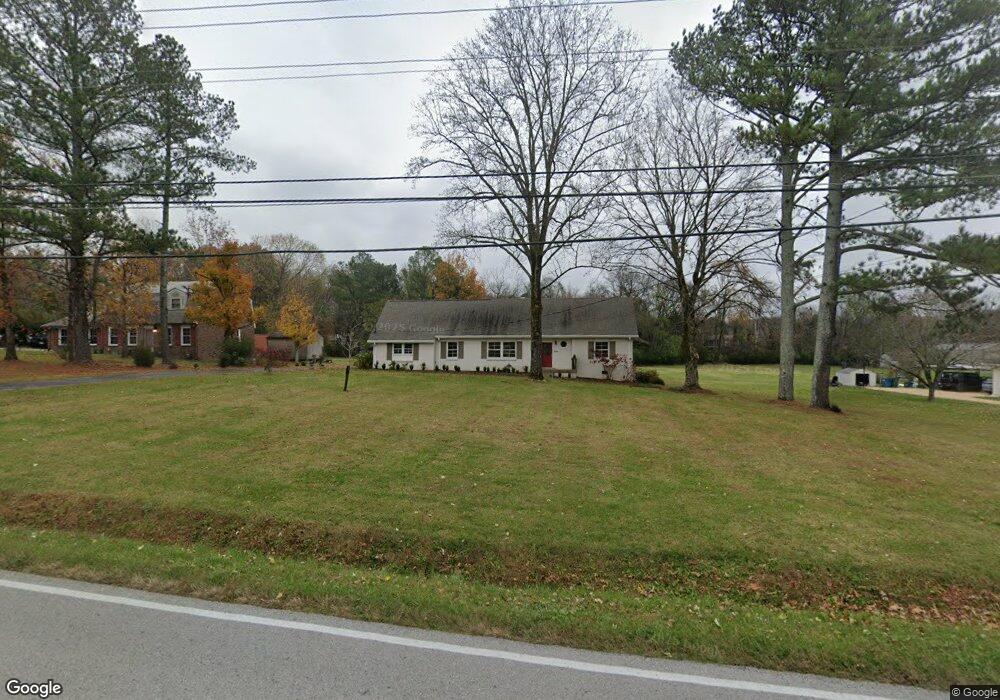
1322 Saundersville Ferry Rd Mount Juliet, TN 37122
Estimated Value: $467,922 - $565,000
--
Bed
3
Baths
2,656
Sq Ft
$200/Sq Ft
Est. Value
About This Home
This home is located at 1322 Saundersville Ferry Rd, Mount Juliet, TN 37122 and is currently estimated at $531,481, approximately $200 per square foot. 1322 Saundersville Ferry Rd is a home located in Wilson County with nearby schools including Lakeview Elementary School, Mt. Juliet Middle School, and Green Hill High School.
Ownership History
Date
Name
Owned For
Owner Type
Purchase Details
Closed on
Jun 23, 2016
Sold by
Curtis Kirk R and Curtis Kirk R
Bought by
Curtis Cynthia L and Curtis C
Current Estimated Value
Purchase Details
Closed on
Feb 11, 2016
Sold by
Curtis Kirk R
Bought by
Curtis Cynthia Lynn
Purchase Details
Closed on
Aug 30, 1995
Bought by
Curtis Kirk R
Purchase Details
Closed on
May 7, 1975
Bought by
Edwards James & Meritor Mtg Corp
Create a Home Valuation Report for This Property
The Home Valuation Report is an in-depth analysis detailing your home's value as well as a comparison with similar homes in the area
Home Values in the Area
Average Home Value in this Area
Purchase History
| Date | Buyer | Sale Price | Title Company |
|---|---|---|---|
| Curtis Cynthia L | -- | -- | |
| Curtis Cynthia Lynn | -- | -- | |
| Curtis Kirk R | $120,000 | -- | |
| Edwards James & Meritor Mtg Corp | -- | -- |
Source: Public Records
Tax History Compared to Growth
Tax History
| Year | Tax Paid | Tax Assessment Tax Assessment Total Assessment is a certain percentage of the fair market value that is determined by local assessors to be the total taxable value of land and additions on the property. | Land | Improvement |
|---|---|---|---|---|
| 2024 | $1,372 | $71,875 | $25,475 | $46,400 |
| 2022 | $1,372 | $71,875 | $25,475 | $46,400 |
| 2021 | $1,372 | $71,875 | $25,475 | $46,400 |
| 2020 | $1,193 | $71,875 | $25,475 | $46,400 |
| 2019 | $1,193 | $47,375 | $15,500 | $31,875 |
| 2018 | $1,193 | $47,375 | $15,500 | $31,875 |
| 2017 | $1,193 | $47,375 | $15,500 | $31,875 |
| 2016 | $1,193 | $47,375 | $15,500 | $31,875 |
| 2015 | $1,218 | $47,375 | $15,500 | $31,875 |
| 2014 | $1,122 | $43,670 | $0 | $0 |
Source: Public Records
Map
Nearby Homes
- 425 Beth Dr
- 1003 Bellwood Dr
- 3860 Saundersville Ferry Rd
- 316 River Dr
- 877 Saundersville Ferry Rd
- 4245 Nonaville Rd
- 310 Weeping Elm Rd
- 741 Saundersville Ferry Rd
- 1896 Saundersville Ferry Rd
- 306 Estate Dr
- 589 Saundersville Ferry Rd
- 320 Estate Dr
- 622 Oakwood Terrace
- 429 Beacon Hill Dr
- 3009 Nottingham Cir
- 2237 Saundersville Ferry Rd
- 2005 Earl Pearce Cir
- 206 James Matthew Ln
- 300 Dani Ct
- 1010 Noel Dr
- 1333 Saundersville Ferry Rd
- 1280 Saundersville Ferry Rd
- 1350 Saundersville Ferry Rd
- 201 River Dr
- 102 Sun Valley Rd
- 1240 Saundersville Ferry Rd
- 1400 Saundersville Ferry Rd
- 204 River Dr
- 203 River Dr
- 104 Sun Valley Rd
- 508 Lovell Dr
- 101 Sun Valley Rd
- 506 Lovell Dr
- 205 River Dr
- 106 Sun Valley Rd
- 434 Beth Dr
- 103 Sun Valley Rd
- 206 River Dr
- 1200 Saundersville Ferry Rd
- 692 Overlook Dr