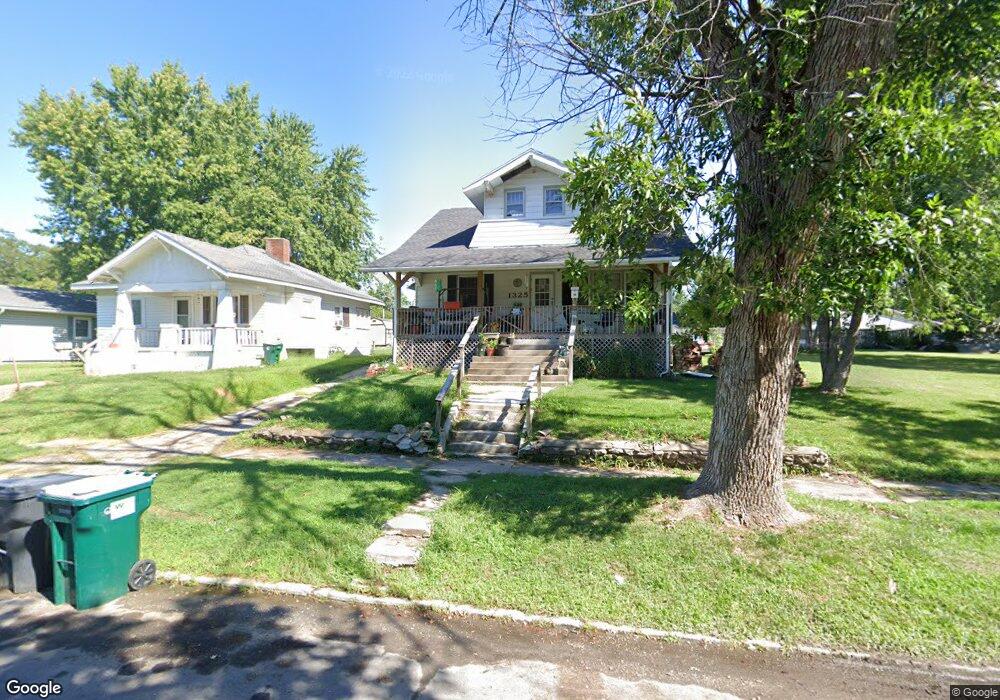
1325 Buchanan St Moberly, MO 65270
Estimated Value: $76,000 - $137,000
4
Beds
1
Bath
1,836
Sq Ft
$62/Sq Ft
Est. Value
About This Home
This home is located at 1325 Buchanan St, Moberly, MO 65270 and is currently estimated at $114,168, approximately $62 per square foot. 1325 Buchanan St is a home located in Randolph County with nearby schools including Moberly Senior High School, St. Pius X. Catholic School, and Maranatha Seventh-day Adventist School.
Ownership History
Date
Name
Owned For
Owner Type
Purchase Details
Closed on
Jul 28, 2015
Sold by
Barron Nicholas
Bought by
Barron Corinna and Barron Nicholas
Current Estimated Value
Purchase Details
Closed on
Jun 11, 2007
Sold by
Meyer Stephanie and Barron Stephanie
Bought by
Barron Nicholas
Create a Home Valuation Report for This Property
The Home Valuation Report is an in-depth analysis detailing your home's value as well as a comparison with similar homes in the area
Home Values in the Area
Average Home Value in this Area
Purchase History
| Date | Buyer | Sale Price | Title Company |
|---|---|---|---|
| Barron Corinna | -- | None Available | |
| Barron Nicholas | -- | -- |
Source: Public Records
Tax History
| Year | Tax Paid | Tax Assessment Tax Assessment Total Assessment is a certain percentage of the fair market value that is determined by local assessors to be the total taxable value of land and additions on the property. | Land | Improvement |
|---|---|---|---|---|
| 2025 | $517 | $7,930 | $1,960 | $5,970 |
| 2024 | $5 | $7,100 | $1,709 | $5,391 |
| 2023 | $525 | $7,100 | $1,709 | $5,391 |
| 2022 | $493 | $6,850 | $1,711 | $5,139 |
| 2020 | $493 | $6,850 | $1,711 | $5,139 |
| 2019 | $492 | $6,850 | $1,711 | $5,139 |
| 2018 | $483 | $6,750 | $1,711 | $5,039 |
| 2017 | $482 | $6,740 | $0 | $0 |
| 2016 | $462 | $6,500 | $0 | $0 |
| 2014 | -- | $6,840 | $0 | $0 |
| 2013 | -- | $6,840 | $0 | $0 |
| 2012 | -- | $7,140 | $0 | $0 |
Source: Public Records
Map
Nearby Homes
- 1309 Buchanan St
- 0 Buchanan St
- 1412 Buchanan St
- 1414 Buchanan St
- 1415 Scott St
- 1123 Concannon St
- 1029 Concannon St
- 1126 Franklin St
- 1206 W Highway 24
- 1 Stone Ave
- 809 Concannon St
- 911 W Reed St
- 1004 W Reed St
- 953 W Rollins St
- 816 W Reed St
- 1050 County Road 1218
- 724 W Rollins St
- 959 U S 24
- 710 W Rollins St
- 0 Highway 24
- 1315 Buchanan St
- 1311 Buchanan St
- 1327 Buchanan St
- 1318 Quinn St
- 1329 Buchanan St
- 1314 Quinn St
- 1330 Quinn St
- 1310 Quinn St
- 1322 Buchanan St
- 1303 Buchanan St
- 1326 Buchanan St
- 1308 Buchanan St
- 1401 Buchanan St
- 923 Emerson St
- 1306 Buchanan St
- 1301 Buchanan St
- 1400 Buchanan St
- 1400 Quinn St
- 1407 Buchanan St
- 1317 Henry St
Your Personal Tour Guide
Ask me questions while you tour the home.