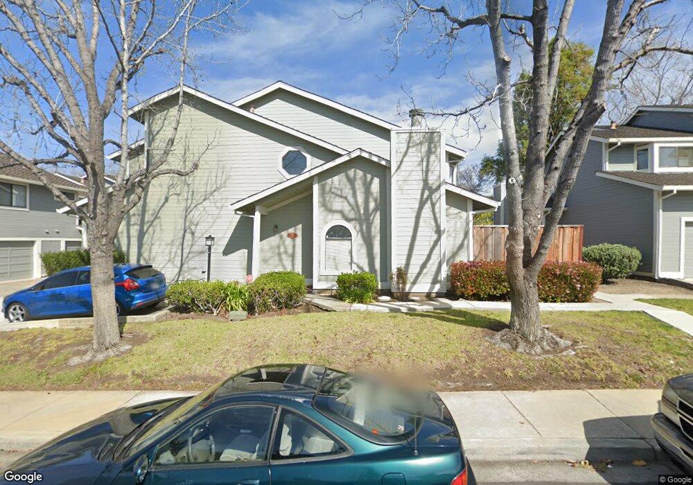
1329 Daniel Ct Milpitas, CA 95035
Estimated Value: $781,000 - $1,038,000
2
Beds
4
Baths
1,223
Sq Ft
$748/Sq Ft
Est. Value
About This Home
This home is located at 1329 Daniel Ct, Milpitas, CA 95035 and is currently estimated at $914,767, approximately $747 per square foot. 1329 Daniel Ct is a home located in Santa Clara County with nearby schools including William Burnett Elementary School, Thomas Russell Middle School, and Milpitas High School.
Ownership History
Date
Name
Owned For
Owner Type
Purchase Details
Closed on
Nov 6, 2015
Sold by
Karl Edward and Louie Karen
Bought by
Karl Louie Living Trust
Current Estimated Value
Purchase Details
Closed on
Apr 2, 2008
Sold by
Mcclure Thomas and Masaquel Alan
Bought by
Karl Edward and Louie Karen
Purchase Details
Closed on
Jun 28, 2005
Sold by
Gunawan Widianto and Sari Yati
Bought by
Mcclure Thomas and Masaquel Alan
Home Financials for this Owner
Home Financials are based on the most recent Mortgage that was taken out on this home.
Original Mortgage
$431,910
Interest Rate
6.7%
Mortgage Type
New Conventional
Purchase Details
Closed on
Nov 20, 1998
Sold by
Binley David and Binley Christine
Bought by
Gunawan Widianto and Sari Yati
Home Financials for this Owner
Home Financials are based on the most recent Mortgage that was taken out on this home.
Original Mortgage
$167,200
Interest Rate
6.87%
Create a Home Valuation Report for This Property
The Home Valuation Report is an in-depth analysis detailing your home's value as well as a comparison with similar homes in the area
Home Values in the Area
Average Home Value in this Area
Purchase History
| Date | Buyer | Sale Price | Title Company |
|---|---|---|---|
| Karl Louie Living Trust | -- | None Available | |
| Karl Edward | $400,000 | Financial Title Company | |
| Mcclure Thomas | $540,000 | Fidelity National Title Ins | |
| Gunawan Widianto | $209,000 | Chicago Title |
Source: Public Records
Mortgage History
| Date | Status | Borrower | Loan Amount |
|---|---|---|---|
| Previous Owner | Mcclure Thomas | $431,910 | |
| Previous Owner | Gunawan Widianto | $167,200 |
Source: Public Records
Tax History
| Year | Tax Paid | Tax Assessment Tax Assessment Total Assessment is a certain percentage of the fair market value that is determined by local assessors to be the total taxable value of land and additions on the property. | Land | Improvement |
|---|---|---|---|---|
| 2025 | $6,101 | $525,386 | $262,693 | $262,693 |
| 2024 | $6,101 | $515,086 | $257,543 | $257,543 |
| 2023 | $6,082 | $504,988 | $252,494 | $252,494 |
| 2022 | $6,062 | $495,088 | $247,544 | $247,544 |
| 2021 | $5,975 | $485,382 | $242,691 | $242,691 |
| 2020 | $5,872 | $480,406 | $240,203 | $240,203 |
| 2019 | $5,807 | $470,988 | $235,494 | $235,494 |
| 2018 | $5,517 | $461,754 | $230,877 | $230,877 |
| 2017 | $5,448 | $452,700 | $226,350 | $226,350 |
| 2016 | $5,226 | $443,824 | $221,912 | $221,912 |
| 2015 | $5,174 | $437,158 | $218,579 | $218,579 |
| 2014 | -- | $428,596 | $214,298 | $214,298 |
Source: Public Records
Map
Nearby Homes
- 1103 Creed St
- 1000 Jacklin Rd
- 1995 Old Calaveras Rd
- 685 Parvin Dr
- 1308 N Hillview Dr
- 258 Lynn Ave
- 25 Terfidia Ln
- 1647 Jupiter Dr
- 136 Lawton Dr
- 60 Jacklin Place
- 1637 Roger St
- 390 Valmy St
- 808 Cameron Cir
- 496 Dempsey Rd Unit 199
- 397 S Park Victoria Dr
- 479 Dixon Rd
- 484 Dempsey Rd Unit 186
- 210 Sunnyhills Ct Unit 10
- 529 Bryce Ct
- 7280 Marylinn Dr
- 1331 Daniel Ct
- 1327 Daniel Ct
- 1333 Daniel Ct
- 1335 Daniel Ct
- 1321 Daniel Ct
- 1323 Daniel Ct
- 1319 Daniel Ct
- 1325 Daniel Ct
- 1337 Daniel Ct
- 1313 Daniel Ct
- 1311 Daniel Ct
- 1326 Daniel Ct
- 1317 Daniel Ct
- 1315 Daniel Ct
- 1344 Daniel Ct
- 1334 Daniel Ct
- 1318 Daniel Ct
- 1342 Daniel Ct
- 1359 Jacklin Rd
- 1310 Daniel Ct
Your Personal Tour Guide
Ask me questions while you tour the home.