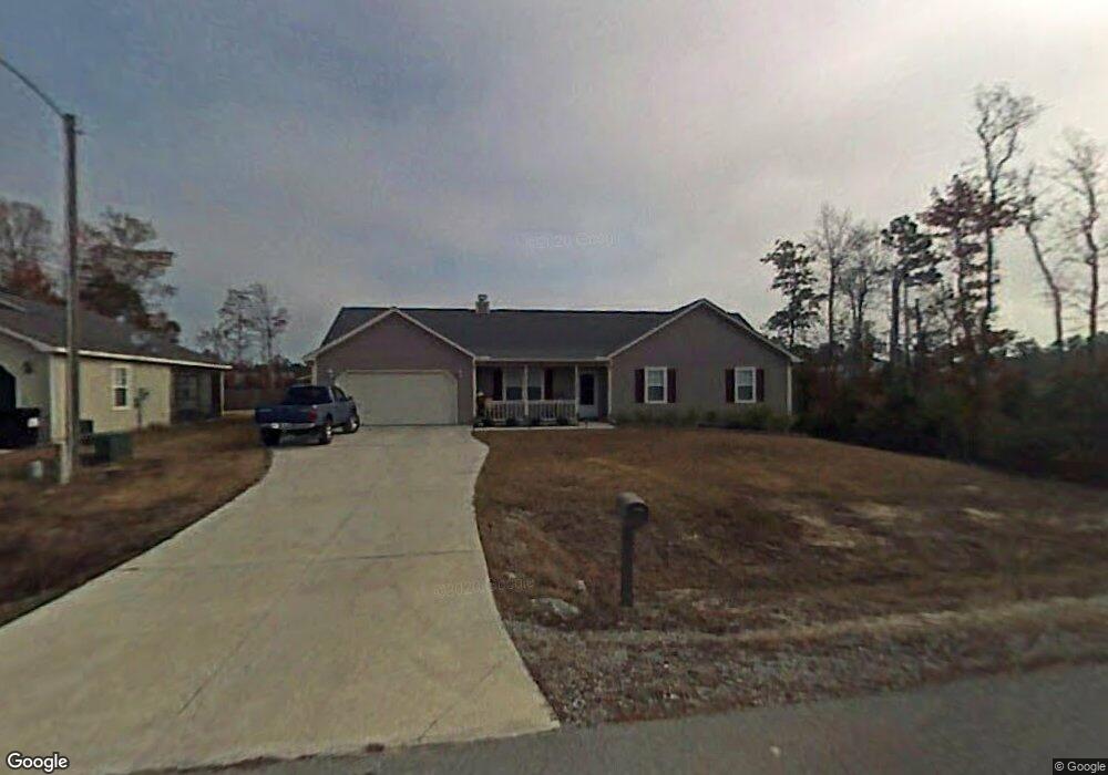
133 Byrum Run Hubert, NC 28539
Hubert NeighborhoodEstimated Value: $246,000 - $267,000
3
Beds
2
Baths
1,600
Sq Ft
$162/Sq Ft
Est. Value
About This Home
This home is located at 133 Byrum Run, Hubert, NC 28539 and is currently estimated at $258,855, approximately $161 per square foot. 133 Byrum Run is a home located in Onslow County with nearby schools including Sand Ridge Elementary School, Swansboro Middle School, and Swansboro High School.
Ownership History
Date
Name
Owned For
Owner Type
Purchase Details
Closed on
Aug 30, 2005
Sold by
Hurst Management Associates Inc
Bought by
Northcott Christopher D and Northcott Paula M
Current Estimated Value
Home Financials for this Owner
Home Financials are based on the most recent Mortgage that was taken out on this home.
Original Mortgage
$127,176
Outstanding Balance
$67,697
Interest Rate
5.77%
Mortgage Type
VA
Estimated Equity
$191,158
Purchase Details
Closed on
Aug 29, 2005
Sold by
Parnell Kinlaw Group Inc
Bought by
Hurst Management Associates Inc
Home Financials for this Owner
Home Financials are based on the most recent Mortgage that was taken out on this home.
Original Mortgage
$127,176
Outstanding Balance
$67,697
Interest Rate
5.77%
Mortgage Type
VA
Estimated Equity
$191,158
Create a Home Valuation Report for This Property
The Home Valuation Report is an in-depth analysis detailing your home's value as well as a comparison with similar homes in the area
Home Values in the Area
Average Home Value in this Area
Purchase History
| Date | Buyer | Sale Price | Title Company |
|---|---|---|---|
| Northcott Christopher D | $124,500 | None Available | |
| Hurst Management Associates Inc | -- | None Available |
Source: Public Records
Mortgage History
| Date | Status | Borrower | Loan Amount |
|---|---|---|---|
| Open | Northcott Christopher D | $127,176 | |
| Closed | Hurst Management Associates Inc | $127,176 |
Source: Public Records
Tax History
| Year | Tax Paid | Tax Assessment Tax Assessment Total Assessment is a certain percentage of the fair market value that is determined by local assessors to be the total taxable value of land and additions on the property. | Land | Improvement |
|---|---|---|---|---|
| 2025 | $1,002 | $197,964 | $40,000 | $157,964 |
| 2024 | $1,002 | $197,964 | $40,000 | $157,964 |
| 2023 | $1,002 | $197,964 | $40,000 | $157,964 |
| 2022 | $1,002 | $197,964 | $40,000 | $157,964 |
| 2021 | $755 | $152,150 | $30,000 | $122,150 |
| 2020 | $752 | $151,730 | $30,000 | $121,730 |
| 2019 | $1,070 | $151,730 | $30,000 | $121,730 |
| 2018 | $1,070 | $151,730 | $30,000 | $121,730 |
| 2017 | $964 | $142,770 | $30,000 | $112,770 |
| 2016 | $964 | $142,770 | $0 | $0 |
| 2015 | $964 | $142,770 | $0 | $0 |
| 2014 | $964 | $142,770 | $0 | $0 |
Source: Public Records
Map
Nearby Homes
- 128 Daphne Dr
- 170 McCausley Rd Unit 10
- 206 Fox Way N
- 222 Natalie Ln
- 327 Buckhead Rd
- 316 Josie Ct
- 127 Glenwood Dr
- 106 N Ivy Dr
- 442 Dion Dr
- 229 Gray Fox Run
- 307 Kenilworth Place
- 108 Foxlair Dr
- 277 Surfside Landing Blvd Unit Lot 115
- 115 Spain Dr
- 280 Surfside Landing Blvd Unit Lot 113
- 423 Dion Dr
- 153 Glenwood Dr
- 4 Willis Landing Rd
- 142 Parnell Rd
- 306 Foxtrace Ln
Your Personal Tour Guide
Ask me questions while you tour the home.