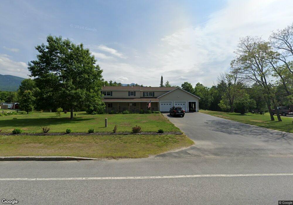
133 Us Route 302 W Whitefield, NH 03598
Estimated Value: $487,000 - $550,000
3
Beds
4
Baths
2,282
Sq Ft
$225/Sq Ft
Est. Value
About This Home
This home is located at 133 Us Route 302 W, Whitefield, NH 03598 and is currently estimated at $514,073, approximately $225 per square foot. 133 Us Route 302 W is a home with nearby schools including Whitefield Elementary School and White Mountains Regional High School.
Ownership History
Date
Name
Owned For
Owner Type
Purchase Details
Closed on
Feb 23, 2021
Sold by
Johnson Timothy I
Bought by
Johnson Timothy I and Johnson Barbara E
Current Estimated Value
Home Financials for this Owner
Home Financials are based on the most recent Mortgage that was taken out on this home.
Original Mortgage
$156,000
Outstanding Balance
$126,736
Interest Rate
2.7%
Mortgage Type
New Conventional
Estimated Equity
$387,337
Purchase Details
Closed on
Apr 30, 2019
Sold by
Jellison Benjamin C and Jellison Melissa A
Bought by
Johnson Timothy J
Home Financials for this Owner
Home Financials are based on the most recent Mortgage that was taken out on this home.
Original Mortgage
$159,900
Interest Rate
4.2%
Mortgage Type
New Conventional
Create a Home Valuation Report for This Property
The Home Valuation Report is an in-depth analysis detailing your home's value as well as a comparison with similar homes in the area
Home Values in the Area
Average Home Value in this Area
Purchase History
| Date | Buyer | Sale Price | Title Company |
|---|---|---|---|
| Johnson Timothy I | -- | None Available | |
| Johnson Timothy I | -- | None Available | |
| Johnson Timothy J | $259,933 | -- | |
| Johnson Timothy J | $259,933 | -- |
Source: Public Records
Mortgage History
| Date | Status | Borrower | Loan Amount |
|---|---|---|---|
| Open | Johnson Timothy I | $156,000 | |
| Previous Owner | Johnson Timothy J | $159,900 |
Source: Public Records
Tax History Compared to Growth
Tax History
| Year | Tax Paid | Tax Assessment Tax Assessment Total Assessment is a certain percentage of the fair market value that is determined by local assessors to be the total taxable value of land and additions on the property. | Land | Improvement |
|---|---|---|---|---|
| 2024 | $4,385 | $368,500 | $107,100 | $261,400 |
| 2023 | $4,544 | $368,500 | $107,100 | $261,400 |
| 2022 | $4,466 | $368,500 | $107,100 | $261,400 |
| 2021 | $3,971 | $207,600 | $35,800 | $171,800 |
| 2020 | $4,412 | $207,600 | $35,800 | $171,800 |
| 2019 | $4,112 | $205,600 | $35,800 | $169,800 |
| 2018 | $4,048 | $205,600 | $35,800 | $169,800 |
| 2015 | $3,768 | $198,019 | $38,800 | $159,219 |
| 2011 | $2,799 | $206,590 | $49,280 | $157,310 |
Source: Public Records
Map
Nearby Homes
- 0 Route 3 N Unit 5049041
- 213 Route 3 N
- 407 U S 3
- 480 U S 3
- 59 Parker Rd
- 348 Parker Rd
- 00 Beechwood Dr Unit 11.3
- 1478 U S 3
- 289 Ledgewood Dr
- 000 Ledgewood Dr
- 000 Ledgewood Dr Unit 9.8
- 2229 Route 3 N
- 258 Crawford Ridge Rd Unit 7
- 254 Crawford Ridge Rd Unit 3
- 305 Crawford Ridge Rd Unit 14
- 62 Belabachi Rd
- 527 Hannah Loop Unit 58
- 528 Trudeau Rd
- 00 Moose Trail Rd Unit 560000
- 10 Mount Madison Ln Unit 7
- 130 Route 302 W
- 123 Us Route 302 W
- 145 Us Route 302 W
- 133 U S 302
- 135 U S 302
- 115 Route 302 W
- 115 Us Route 302 W
- 115 Route 302
- 159 Us Route 302
- 159 Us 302 Route
- 159 Main St 302 Route
- 112 Us Route 302 W
- 128 Us Route 302 W
- 119 Mountain View Rd
- 129 Mountain View Rd
- 150 U S 302
- 83 U S 302
- 83 Us Route 302 W
- 135 Mountain View Rd
- 105 Mountain View Rd