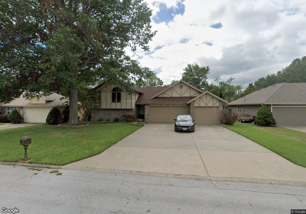
1338 E Highpoint St Springfield, MO 65804
Southwest Springfield NeighborhoodEstimated Value: $374,063 - $439,000
4
Beds
3
Baths
2,378
Sq Ft
$167/Sq Ft
Est. Value
About This Home
This home is located at 1338 E Highpoint St, Springfield, MO 65804 and is currently estimated at $398,266, approximately $167 per square foot. 1338 E Highpoint St is a home located in Greene County with nearby schools including Walt Disney Elementary School, Cherokee Middle School, and Kickapoo High School.
Ownership History
Date
Name
Owned For
Owner Type
Purchase Details
Closed on
May 30, 2013
Sold by
Zuhlke Cherie L
Bought by
Zuhlke David G
Current Estimated Value
Home Financials for this Owner
Home Financials are based on the most recent Mortgage that was taken out on this home.
Original Mortgage
$60,000
Interest Rate
3.41%
Mortgage Type
New Conventional
Purchase Details
Closed on
Mar 19, 2013
Sold by
Zuhlke Cherie Lynn
Bought by
Zuhlke David Glen
Create a Home Valuation Report for This Property
The Home Valuation Report is an in-depth analysis detailing your home's value as well as a comparison with similar homes in the area
Home Values in the Area
Average Home Value in this Area
Purchase History
| Date | Buyer | Sale Price | Title Company |
|---|---|---|---|
| Zuhlke David G | -- | None Available | |
| Zuhlke David Glen | -- | None Available |
Source: Public Records
Mortgage History
| Date | Status | Borrower | Loan Amount |
|---|---|---|---|
| Closed | Zuhlke David G | $60,000 |
Source: Public Records
Tax History
| Year | Tax Paid | Tax Assessment Tax Assessment Total Assessment is a certain percentage of the fair market value that is determined by local assessors to be the total taxable value of land and additions on the property. | Land | Improvement |
|---|---|---|---|---|
| 2025 | $2,539 | $49,270 | $10,110 | $39,160 |
| 2024 | $2,413 | $43,570 | $10,110 | $33,460 |
| 2023 | $2,400 | $43,570 | $10,110 | $33,460 |
| 2022 | $1,695 | $31,540 | $10,110 | $21,430 |
| 2021 | $1,695 | $31,540 | $10,110 | $21,430 |
| 2020 | $1,660 | $29,300 | $10,110 | $19,190 |
| 2019 | $1,613 | $29,300 | $10,110 | $19,190 |
| 2018 | $1,629 | $29,530 | $9,390 | $20,140 |
| 2017 | $1,613 | $29,530 | $9,390 | $20,140 |
| 2016 | $1,614 | $29,530 | $9,390 | $20,140 |
| 2015 | $1,601 | $29,530 | $9,390 | $20,140 |
| 2014 | $1,562 | $35,630 | $9,770 | $25,860 |
Source: Public Records
Map
Nearby Homes
- 1309 E Knobhill St
- 1221 E Knobhill St
- 5628 S Moonshine Ct
- 5521 S Ridge Top Ave
- 1052 E Oak Tree Ln
- 1639 E Oak Creek
- 1062 E Evans St
- 5308 S Kissick Ave
- 5895 S Teters Ct
- 5456 S Hazel Ave
- 916 E Meadowlark St
- 1002 E Gaslight Dr
- 930 E Canterbury St
- 5155 S Hampton Ave
- 903 E Gaslight Dr
- 1414 E Wilder Dr
- 922 E Manchester Dr
- 5112 S Hampton Ave
- 6008 S Mccann Ave
- 4959 S Mccann Ave
- 1342 E Highpoint St
- 1334 E Highpoint St
- 1359 Abele Cove
- 1365 Abele Cove
- 1346 E Highpoint St
- 1330 E Highpoint St
- 1337 E Highpoint St
- 1353 Abele Cove
- 1341 E Highpoint St
- 1333 E Highpoint St
- 1326 E Highpoint St
- 1345 E Highpoint St
- 1329 E Highpoint St
- 1354 Abele Cove
- 1347 Abele Cove
- 1325 E Highpoint St
- 1348 Abele Cove
- 1341 Abele Cove
- 1322 E Highpoint St
- 1338 E Knobhill St
Your Personal Tour Guide
Ask me questions while you tour the home.