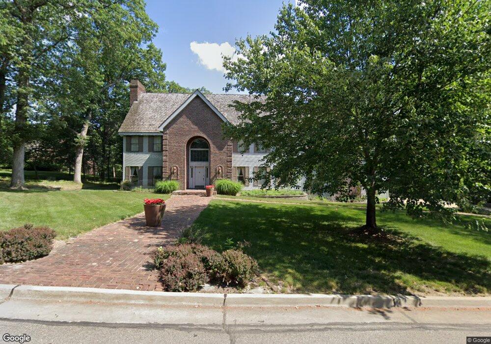
13399 Oak Brook Dr Urbandale, IA 50323
Estimated Value: $812,617 - $1,493,000
7
Beds
6
Baths
4,980
Sq Ft
$214/Sq Ft
Est. Value
About This Home
This home is located at 13399 Oak Brook Dr, Urbandale, IA 50323 and is currently estimated at $1,066,206, approximately $214 per square foot. 13399 Oak Brook Dr is a home located in Polk County with nearby schools including Westridge Elementary School, Indian Hills Junior High School, and Valley Southwoods Freshman High School.
Ownership History
Date
Name
Owned For
Owner Type
Purchase Details
Closed on
Nov 6, 2018
Sold by
Sookram Jhennifer K
Bought by
Sookram Jhennifer K and Elizabeth J Nelson Living Trust
Current Estimated Value
Purchase Details
Closed on
Mar 2, 1998
Sold by
Carano Donald C and Carano Madeleine E
Bought by
Holub Pam K
Home Financials for this Owner
Home Financials are based on the most recent Mortgage that was taken out on this home.
Original Mortgage
$225,000
Interest Rate
6.54%
Create a Home Valuation Report for This Property
The Home Valuation Report is an in-depth analysis detailing your home's value as well as a comparison with similar homes in the area
Home Values in the Area
Average Home Value in this Area
Purchase History
| Date | Buyer | Sale Price | Title Company |
|---|---|---|---|
| Sookram Jhennifer K | -- | None Available | |
| Holub Pam K | $424,500 | -- |
Source: Public Records
Mortgage History
| Date | Status | Borrower | Loan Amount |
|---|---|---|---|
| Previous Owner | Holub Pam K | $225,000 |
Source: Public Records
Tax History Compared to Growth
Tax History
| Year | Tax Paid | Tax Assessment Tax Assessment Total Assessment is a certain percentage of the fair market value that is determined by local assessors to be the total taxable value of land and additions on the property. | Land | Improvement |
|---|---|---|---|---|
| 2025 | $10,924 | $805,600 | $164,900 | $640,700 |
| 2024 | $10,924 | $721,600 | $146,400 | $575,200 |
| 2023 | $10,558 | $721,600 | $146,400 | $575,200 |
| 2022 | $10,430 | $573,600 | $119,800 | $453,800 |
| 2021 | $11,202 | $573,600 | $119,800 | $453,800 |
| 2020 | $11,048 | $583,000 | $122,500 | $460,500 |
| 2019 | $11,430 | $583,000 | $122,500 | $460,500 |
| 2018 | $11,048 | $575,500 | $116,100 | $459,400 |
| 2017 | $10,682 | $575,500 | $116,100 | $459,400 |
| 2016 | $10,418 | $543,900 | $108,900 | $435,000 |
| 2015 | $10,418 | $543,900 | $108,900 | $435,000 |
| 2014 | $10,076 | $521,700 | $103,900 | $417,800 |
Source: Public Records
Map
Nearby Homes
- 13282 Oak Brook Dr
- 13425 Ridgeview Dr
- 13208 Rocklyn Dr
- 12993 Oak Brook Dr
- 13504 Sheridan Ave
- 12926 Timberline Dr
- 13165 Pinecrest Ln
- 2216 NW 136th St
- 14111 Oak Brook Dr
- 3837 NW 183rd St
- 14130 Wilden Dr
- 14134 Wilden Dr
- 14136 Wilden Dr
- 2094 NW 137th St
- 12614 Ridgeview Dr
- 3943 NW 181st St
- 4010 NW 181st St
- 3997 NW 181st St
- 13953 Lake Shore Dr
- 14405 Holcomb Ave
- 13465 Oak Brook Dr
- 2976 133rd Way
- 13343 Oak Brook Dr
- 13422 Oak Brook Dr
- 13376 Oak Brook Dr
- 2990 133rd Way
- 13521 Oak Brook Dr
- 13318 Oak Brook Dr
- 13468 Oak Brook Dr
- 2996 133rd Way
- 2935 133rd Way
- 13518 Oakbrook Dr
- 13525 Oak Brook Dr
- 13518 Oak Brook Dr
- 2976 132nd Ct
- 2934 132nd Ct
- 13524 Oak Brook Dr
- 13232 Oak Brook Dr
- 3506 132nd Ct
- 3505 132nd Ct