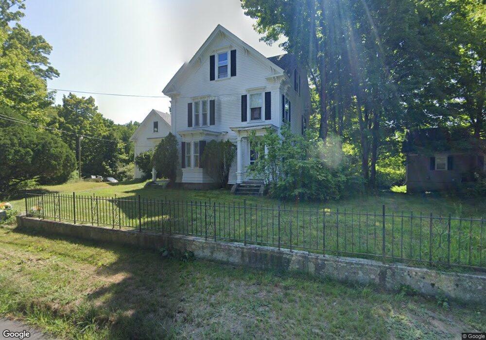
134 Railroad Ave Epping, NH 03042
Estimated Value: $549,763 - $630,000
About This Home
This home is located at 134 Railroad Ave, Epping, NH 03042 and is currently estimated at $585,191, approximately $250 per square foot. 134 Railroad Ave is a home located in Rockingham County with nearby schools including Epping Elementary School, Epping Middle School, and Epping High School.
Ownership History
We collect this data history from publicly available records. To have your information removed, we recommend requesting removal directly through your county’s website.
Purchase Details
Home Values in the Area
Average Home Value in this Area
Purchase History
We collect this data history from publicly available records. To have your information removed, we recommend requesting removal directly through your county’s website.
| Date | Buyer | Sale Price | Title Company |
|---|---|---|---|
| -- | -- |
Mortgage History
We collect this data history from publicly available records. To have your information removed, we recommend requesting removal directly through your county’s website.
| Date | Status | Borrower | Loan Amount |
|---|---|---|---|
| Open | $100,000 |
Tax History
We collect this data history from publicly available records. To have your information removed, we recommend requesting removal directly through your county’s website.
| Year | Tax Paid | Tax Assessment Tax Assessment Total Assessment is a certain percentage of the fair market value that is determined by local assessors to be the total taxable value of land and additions on the property. | Land | Improvement |
|---|---|---|---|---|
| 2025 | $7,199 | $479,900 | $160,900 | $319,000 |
| 2024 | $7,191 | $285,000 | $83,900 | $201,100 |
| 2023 | $6,669 | $285,000 | $83,900 | $201,100 |
| 2022 | $6,324 | $281,200 | $83,900 | $197,300 |
| 2021 | $5,914 | $263,800 | $83,900 | $179,900 |
| 2020 | $6,236 | $263,800 | $83,900 | $179,900 |
| 2019 | $5,698 | $205,700 | $77,500 | $128,200 |
| 2018 | $5,336 | $205,700 | $77,500 | $128,200 |
| 2017 | $5,336 | $205,700 | $77,500 | $128,200 |
| 2016 | $5,336 | $205,700 | $77,500 | $128,200 |
| 2015 | $5,336 | $205,700 | $77,500 | $128,200 |
| 2014 | $4,823 | $197,500 | $77,500 | $120,000 |
| 2013 | $4,793 | $197,500 | $77,500 | $120,000 |
Map
- 80 St Laurent St
- 6 Biggs Ave Unit B
- 19 Biggs Ave Unit A
- 7A Sunset Ridge Rd Unit A
- 10A Cardinal Ln
- 38 Jannell Ct
- 25 Mill St
- 82 Fremont Rd Unit A
- 65 Sunset Ridge Rd Unit 65B
- 60 Sunset Ridge Rd Unit 60A
- 63 Sunset Ridge Rd Unit 63A
- 20 Center Ct
- 1B Connor Ct Unit 1B
- 1A Connor Ct Unit 1A
- 13 Elm St
- 54 Sunset Ridge Rd Unit 54B
- 55 Sunset Ridge Rd Unit 55A
- 55 Sunset Ridge Rd Unit 55B
- 3B Connor Ct Unit 3B
- 27 Mulberry Ln
- 00 Fremont Rd
- 96 Saint Laurent St
- 96 St Laurent St
- 140 Railroad Ave
- 129 Railroad Ave
- 99 St Laurent St
- 126 Railroad Ave
- 92 St Laurent St
- 2 Leddy Dr
- 116 Railroad Ave
- 75 Leddy Dr Unit 16
- 91 St Laurent St
- 9 Blackford Ln Unit 8
- 29 Leddy Dr
- 31 Leddy Dr
- 60 Leddy Dr
- 62 Leddy Dr
- 72 Leddy Dr
- 74 Leddy Dr
- 71 Leddy Dr
Ask me questions while you tour the home.