Estimated Value: $980,661 - $1,114,000
4
Beds
2
Baths
2,026
Sq Ft
$513/Sq Ft
Est. Value
About This Home
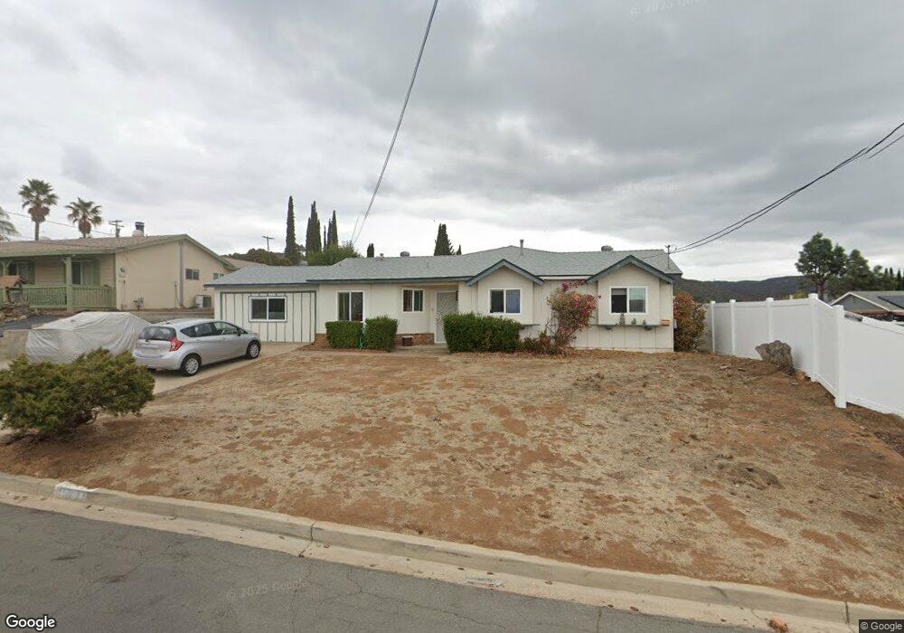
This home is located at 13429 Ogunquit Ave, Poway, CA 92064 and is currently estimated at $1,039,665, approximately $513 per square foot. 13429 Ogunquit Ave is a home located in San Diego County with nearby schools including Garden Road Elementary, Twin Peaks Middle, and Poway High.
Ownership History
Date
Name
Owned For
Owner Type
Purchase Details
Closed on
Jul 26, 2019
Sold by
Show Ronald William
Bought by
Show Ronald W
Current Estimated Value
Home Financials for this Owner
Home Financials are based on the most recent Mortgage that was taken out on this home.
Original Mortgage
$967,500
Interest Rate
5.47%
Mortgage Type
FHA
Purchase Details
Closed on
Dec 18, 2008
Sold by
Jordan Carmela Ann
Bought by
Jordan Nicholas J
Create a Home Valuation Report for This Property
The Home Valuation Report is an in-depth analysis detailing your home's value as well as a comparison with similar homes in the area
Home Values in the Area
Average Home Value in this Area
Purchase History
| Date | Buyer | Sale Price | Title Company |
|---|---|---|---|
| Show Ronald W | -- | Timios Title A Ca Corp | |
| Jordan Nicholas J | -- | Accommodation |
Source: Public Records
Mortgage History
| Date | Status | Borrower | Loan Amount |
|---|---|---|---|
| Closed | Show Ronald W | $967,500 |
Source: Public Records
Tax History
| Year | Tax Paid | Tax Assessment Tax Assessment Total Assessment is a certain percentage of the fair market value that is determined by local assessors to be the total taxable value of land and additions on the property. | Land | Improvement |
|---|---|---|---|---|
| 2025 | $878 | $78,780 | $27,519 | $51,261 |
| 2024 | $878 | $77,236 | $26,980 | $50,256 |
| 2023 | $858 | $75,722 | $26,451 | $49,271 |
| 2022 | $843 | $74,238 | $25,933 | $48,305 |
| 2021 | $832 | $72,783 | $25,425 | $47,358 |
| 2020 | $821 | $72,038 | $25,165 | $46,873 |
| 2019 | $800 | $70,626 | $24,672 | $45,954 |
| 2018 | $778 | $69,242 | $24,189 | $45,053 |
| 2017 | $170 | $67,885 | $23,715 | $44,170 |
| 2016 | $740 | $66,554 | $23,250 | $43,304 |
| 2015 | $729 | $65,555 | $22,901 | $42,654 |
| 2014 | $713 | $64,272 | $22,453 | $41,819 |
Source: Public Records
Map
Nearby Homes
- 13419 Sebago Ave
- 14610 Fairburn St
- 14550 Dehia St
- 14525 Kittery St
- 14118 Ipava Dr
- 14298 Ipava Dr
- 13735 Fairgate Dr
- 0 Indian Springs Rd Unit NDP2602071
- 14003 Jasmine Ave Unit 193
- 14089 Pomegranate Ave Unit 214
- 13908 Hibiscus Ave Unit 40
- 13941 Wisteria Ave
- 000 Carlson Ct 9 Unit 9
- 13746 Paseo Bonita
- 13947 Midland Rd
- 13850 Midgrove Ct
- 0 Pebble Canyon Dr Unit PTP2505722
- 13972 Poway Valley Rd
- 13976 Country Creek Rd
- 44 Carlson Ct
- 13435 Ogunquit Ave
- 14552 Topsham St
- 14558 Topsham St
- 13430 Acton Ave
- 13436 Acton Ave
- 13441 Ogunquit Ave
- 14564 Topsham St
- 13434 Ogunquit Ave
- 13440 Ogunquit Ave
- 13428 Ogunquit Ave
- 13442 Acton Ave
- 13446 Ogunquit Ave
- 13422 Ogunquit Ave
- 14555 Bowdoin Rd
- 14567 Bowdoin Rd
- 14553 Topsham St
- 14559 Topsham St
- 13439 Buxton Ave
- 13445 Buxton Ave
- 13433 Buxton Ave
Your Personal Tour Guide
Ask me questions while you tour the home.