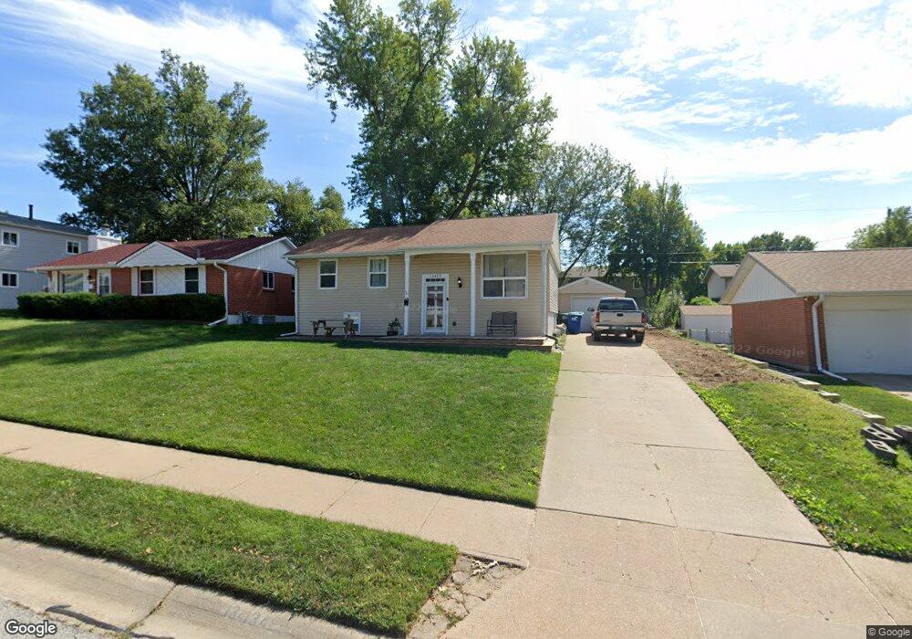
13429 Spring St Omaha, NE 68144
Montclair West NeighborhoodEstimated Value: $239,000 - $259,000
4
Beds
2
Baths
1,636
Sq Ft
$154/Sq Ft
Est. Value
About This Home
This home is located at 13429 Spring St, Omaha, NE 68144 and is currently estimated at $251,714, approximately $153 per square foot. 13429 Spring St is a home located in Douglas County with nearby schools including Willa Cather Elementary School, Millard North Middle School, and Millard North High School.
Ownership History
Date
Name
Owned For
Owner Type
Purchase Details
Closed on
Apr 8, 2015
Sold by
Baker Marie C and Baker William
Bought by
Baker Marie C
Current Estimated Value
Home Financials for this Owner
Home Financials are based on the most recent Mortgage that was taken out on this home.
Original Mortgage
$115,460
Outstanding Balance
$41,931
Interest Rate
3.89%
Mortgage Type
New Conventional
Estimated Equity
$209,783
Purchase Details
Closed on
Apr 30, 2008
Sold by
Singer David E
Bought by
Corrin Marie C
Purchase Details
Closed on
May 30, 2002
Sold by
Fenton Philip M and Fenton Sheryl A
Bought by
Singer David E and Singer Bobbi J
Home Financials for this Owner
Home Financials are based on the most recent Mortgage that was taken out on this home.
Original Mortgage
$107,100
Interest Rate
6.77%
Mortgage Type
FHA
Create a Home Valuation Report for This Property
The Home Valuation Report is an in-depth analysis detailing your home's value as well as a comparison with similar homes in the area
Home Values in the Area
Average Home Value in this Area
Purchase History
| Date | Buyer | Sale Price | Title Company |
|---|---|---|---|
| Baker Marie C | -- | Missouri River Title | |
| Corrin Marie C | $125,000 | -- | |
| Singer David E | $108,000 | -- |
Source: Public Records
Mortgage History
| Date | Status | Borrower | Loan Amount |
|---|---|---|---|
| Open | Baker Marie C | $115,460 | |
| Previous Owner | Singer David E | $107,100 |
Source: Public Records
Tax History
| Year | Tax Paid | Tax Assessment Tax Assessment Total Assessment is a certain percentage of the fair market value that is determined by local assessors to be the total taxable value of land and additions on the property. | Land | Improvement |
|---|---|---|---|---|
| 2025 | $3,239 | $233,200 | $19,800 | $213,400 |
| 2024 | $3,916 | $196,700 | $19,800 | $176,900 |
| 2023 | $3,916 | $196,700 | $19,800 | $176,900 |
| 2022 | $3,456 | $163,500 | $19,800 | $143,700 |
| 2021 | $2,799 | $133,100 | $19,800 | $113,300 |
| 2020 | $2,822 | $133,100 | $19,800 | $113,300 |
| 2019 | $2,758 | $129,700 | $19,800 | $109,900 |
| 2018 | $2,797 | $129,700 | $19,800 | $109,900 |
| 2017 | $2,403 | $113,200 | $19,800 | $93,400 |
| 2016 | $2,354 | $110,800 | $7,400 | $103,400 |
Source: Public Records
Map
Nearby Homes
- 3123 S 134th St
- 3036 S 133rd St
- 2913 S 134th Ave
- 2821 S 134th Ave
- 3365 S 130th St
- 2916 S 137th St
- 1409 S 127th St
- 3505 S 130th St
- 13604 Gold St
- 3424 S 138th St
- 12858 A St
- 3404 S 127th Ave
- 13424 Montclair Dr
- 2305 Royal Wood Dr
- 2256 Royal Wood Dr
- 2223 S 138th St
- 1875 S 131st Ave
- 3112 S 123rd St
- 12535 C St
- 2331 S 124th St
- 13435 Spring St
- 13423 Spring St
- 13415 Spring St
- 13310 Hascall St
- 13316 Hascall St
- 13443 Spring St
- 13308 Hascall St
- 13322 Hascall St
- 13424 Spring St
- 13306 Hascall St
- 13430 Spring St
- 13407 Spring St
- 13416 Spring St
- 13328 Hascall St
- 13436 Spring St
- 13408 Spring St
- 3305 S 133rd St
- 13453 Spring St
- 13334 Hascall St
- 13325 Spring St
Your Personal Tour Guide
Ask me questions while you tour the home.