Estimated Value: $557,000 - $689,000
4
Beds
2
Baths
2,016
Sq Ft
$307/Sq Ft
Est. Value
About This Home
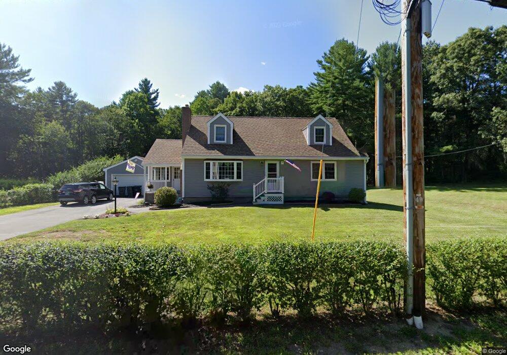
This home is located at 135 N Main St, Salem, NH 03079 and is currently estimated at $619,469, approximately $307 per square foot. 135 N Main St is a home located in Rockingham County with nearby schools including William T. Barron Elementary School, Woodbury School, and Salem High School.
Ownership History
Date
Name
Owned For
Owner Type
Purchase Details
Closed on
Oct 31, 2002
Sold by
Cayer Roland W and Cayer Cynthia M
Bought by
Zannini Robert and Zannini Mary Ellen
Current Estimated Value
Create a Home Valuation Report for This Property
The Home Valuation Report is an in-depth analysis detailing your home's value as well as a comparison with similar homes in the area
Home Values in the Area
Average Home Value in this Area
Purchase History
| Date | Buyer | Sale Price | Title Company |
|---|---|---|---|
| Zannini Robert | $135,000 | -- |
Source: Public Records
Mortgage History
| Date | Status | Borrower | Loan Amount |
|---|---|---|---|
| Open | Zannini Robert | $243,750 |
Source: Public Records
Tax History Compared to Growth
Tax History
| Year | Tax Paid | Tax Assessment Tax Assessment Total Assessment is a certain percentage of the fair market value that is determined by local assessors to be the total taxable value of land and additions on the property. | Land | Improvement |
|---|---|---|---|---|
| 2024 | $7,858 | $446,500 | $154,600 | $291,900 |
| 2023 | $7,523 | $443,600 | $154,600 | $289,000 |
| 2022 | $7,120 | $443,600 | $154,600 | $289,000 |
| 2021 | $7,089 | $443,600 | $154,600 | $289,000 |
| 2020 | $6,564 | $298,100 | $110,200 | $187,900 |
| 2019 | $6,552 | $298,100 | $110,200 | $187,900 |
| 2018 | $6,442 | $298,100 | $110,200 | $187,900 |
| 2017 | $6,212 | $298,100 | $110,200 | $187,900 |
| 2016 | $6,090 | $298,100 | $110,200 | $187,900 |
| 2015 | $5,525 | $258,300 | $109,700 | $148,600 |
| 2014 | $5,370 | $258,300 | $109,700 | $148,600 |
| 2013 | $5,285 | $258,300 | $109,700 | $148,600 |
Source: Public Records
Map
Nearby Homes
- 3 Roux Ave
- 51 Bluff St
- 8 Arcadia Ln
- 8 Stoneybrook Ln
- 27 General Pulaski Dr
- 55A Millville Cir
- 51 Zion Hill Rd
- 5 Betty Ln
- 1 Kimball Ave
- 1 Longview Dr Unit 110
- 1 Longview Dr Unit 203
- 1 Longview Dr Unit 101
- 1 Longview Dr Unit 108
- 1 Longview Dr Unit 401
- 1 Longview Dr Unit 306
- 1 Longview Dr Unit 205
- 1 Longview Dr Unit 106
- 1 Longview Dr Unit 210
- 7 Longview Dr Unit 105
- 4 Longview Dr Unit 201
- 133 N Main St
- 139 N Main St
- 129 N Main St
- 132 N Main St
- 127 N Main St
- 5 Spicket Ln
- 130 N Main St
- 130 N Main St Unit 102
- 130 N Main St Unit 206A
- 130 N Main St Unit 202
- 130 N Main St Unit 201E
- 130 N Main St Unit 201D
- 130 N Main St Unit 201C
- 130 N Main St Unit 201A
- 130 N Main St Unit 203B
- 130 N Main St Unit 203A
- 130 N Main St Unit 201G
- 130 N Main St Unit 204
- 130 N Main St Unit 201B
- 130 N Main St Unit 101