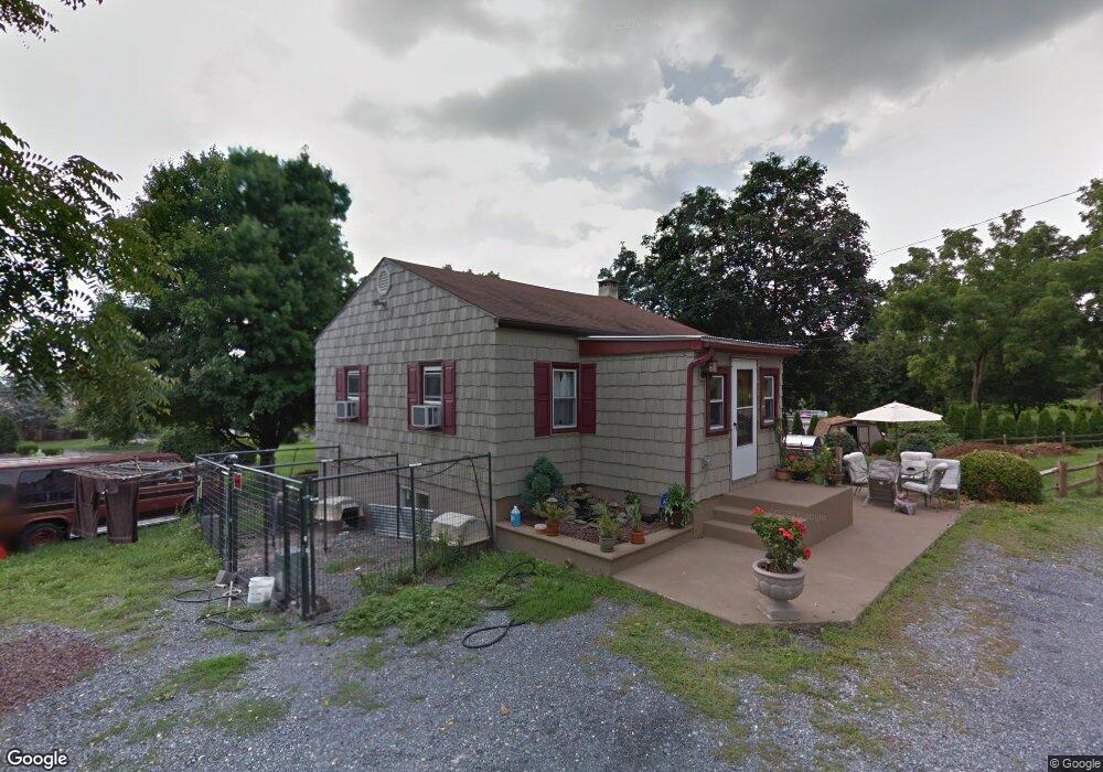
1350 Brookside Rd Allentown, PA 18106
Estimated Value: $267,947 - $329,000
2
Beds
1
Bath
720
Sq Ft
$423/Sq Ft
Est. Value
About This Home
This home is located at 1350 Brookside Rd, Allentown, PA 18106 and is currently estimated at $304,487, approximately $422 per square foot. 1350 Brookside Rd is a home located in Lehigh County with nearby schools including Wescosville Elementary School, Lower Macungie Middle School, and Emmaus High School.
Ownership History
Date
Name
Owned For
Owner Type
Purchase Details
Closed on
Apr 25, 2001
Sold by
Mohr Veronica A and Wilson Veronica
Bought by
Wilson Harry H and Wilson Veronica
Current Estimated Value
Purchase Details
Closed on
Aug 19, 1993
Sold by
Mohr Thomas H and Mohr Veronica A
Bought by
Mohr Veronica A
Purchase Details
Closed on
Sep 14, 1984
Sold by
Hausman Robert J and Hausman Hemphill B
Bought by
Mohr Thomas H and Mohr Veronica A
Purchase Details
Closed on
Feb 1, 1979
Bought by
Hausman Robert J and Hausman Hemphill B
Create a Home Valuation Report for This Property
The Home Valuation Report is an in-depth analysis detailing your home's value as well as a comparison with similar homes in the area
Home Values in the Area
Average Home Value in this Area
Purchase History
| Date | Buyer | Sale Price | Title Company |
|---|---|---|---|
| Wilson Harry H | -- | -- | |
| Mohr Veronica A | -- | -- | |
| Mohr Thomas H | $46,900 | -- | |
| Hausman Robert J | $34,900 | -- |
Source: Public Records
Tax History Compared to Growth
Tax History
| Year | Tax Paid | Tax Assessment Tax Assessment Total Assessment is a certain percentage of the fair market value that is determined by local assessors to be the total taxable value of land and additions on the property. | Land | Improvement |
|---|---|---|---|---|
| 2025 | $3,028 | $118,600 | $46,800 | $71,800 |
| 2024 | $2,929 | $118,600 | $46,800 | $71,800 |
| 2023 | $2,871 | $118,600 | $46,800 | $71,800 |
| 2022 | $2,803 | $118,600 | $71,800 | $46,800 |
| 2021 | $2,743 | $118,600 | $46,800 | $71,800 |
| 2020 | $2,717 | $118,600 | $46,800 | $71,800 |
| 2019 | $2,671 | $118,600 | $46,800 | $71,800 |
| 2018 | $2,636 | $118,600 | $46,800 | $71,800 |
| 2017 | $2,590 | $118,600 | $46,800 | $71,800 |
| 2016 | -- | $118,600 | $46,800 | $71,800 |
| 2015 | -- | $118,600 | $46,800 | $71,800 |
| 2014 | -- | $118,600 | $46,800 | $71,800 |
Source: Public Records
Map
Nearby Homes
- 1385 Brookside Rd
- 5133 Meadow Ln
- 4881 Spruce Rd
- 5300 Hanover Dr
- 5280 Townsquare Dr
- 997 Village Round Unit K
- 997K Village Round Unit 104K
- 1675 Hamlet Dr
- 1270 Minesite Rd
- 5524 Stonecroft Ln
- 5673 Wedge Ln
- 5475 Hamilton Blvd Unit 7
- 5736 Greens Dr
- 5619 Stonecroft Ln
- 5175 Meadowview Dr
- 1045 Barnside Rd
- 1991 Autumn Ridge Rd
- 2173 Brookside Rd
- 2056 Autumn Ridge Rd
- 6007 Timberknoll Dr
- 1340 Brookside Rd
- 1368 Brookside Rd
- 1386 Brookside Rd
- 1398 Brookside Rd
- 1367 Brookside Rd
- 1408 Brookside Rd
- 1345 Brookside Rd
- 1425 Brookside Rd
- 1335 Brookside Rd
- 1450 Brookside Rd
- 1450 Brookside Rd
- 1402 Dayspring Dr
- 1362 Dayspring Dr
- 1424 Dayspring Dr
- 1434 Dove Terrace
- 1428 Dove Terrace
- 1312 Brookside Rd
- 1346 Dayspring Dr
- 1325 Brookside Rd
- 5132 Celia Dr