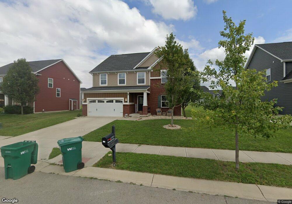
13513 Mancroft Dr Fishers, IN 46037
Estimated Value: $524,000 - $618,000
3
Beds
4
Baths
3,125
Sq Ft
$180/Sq Ft
Est. Value
About This Home
This home is located at 13513 Mancroft Dr, Fishers, IN 46037 and is currently estimated at $561,101, approximately $179 per square foot. 13513 Mancroft Dr is a home with nearby schools including Overland Park Elementary School, Southeastern Elementary School, and Hamilton Southeastern Intermediate / Junior High.
Ownership History
Date
Name
Owned For
Owner Type
Purchase Details
Closed on
Sep 30, 2014
Sold by
Nvr Inc
Bought by
Asghar Adnan and Adnan Friya J
Current Estimated Value
Home Financials for this Owner
Home Financials are based on the most recent Mortgage that was taken out on this home.
Original Mortgage
$56,075
Outstanding Balance
$42,942
Interest Rate
4.07%
Mortgage Type
Credit Line Revolving
Estimated Equity
$518,159
Purchase Details
Closed on
May 30, 2014
Sold by
Saratoga Development Llc
Bought by
Nvr Inc
Create a Home Valuation Report for This Property
The Home Valuation Report is an in-depth analysis detailing your home's value as well as a comparison with similar homes in the area
Home Values in the Area
Average Home Value in this Area
Purchase History
| Date | Buyer | Sale Price | Title Company |
|---|---|---|---|
| Asghar Adnan | -- | None Available | |
| Nvr Inc | -- | None Available |
Source: Public Records
Mortgage History
| Date | Status | Borrower | Loan Amount |
|---|---|---|---|
| Open | Asghar Adnan | $56,075 |
Source: Public Records
Tax History Compared to Growth
Tax History
| Year | Tax Paid | Tax Assessment Tax Assessment Total Assessment is a certain percentage of the fair market value that is determined by local assessors to be the total taxable value of land and additions on the property. | Land | Improvement |
|---|---|---|---|---|
| 2024 | $5,651 | $506,000 | $70,500 | $435,500 |
| 2023 | $5,651 | $488,300 | $70,500 | $417,800 |
| 2022 | $4,609 | $431,100 | $70,500 | $360,600 |
| 2021 | $4,609 | $383,800 | $70,500 | $313,300 |
| 2020 | $4,516 | $372,100 | $70,500 | $301,600 |
| 2019 | $4,516 | $372,100 | $67,400 | $304,700 |
| 2018 | $4,528 | $372,100 | $67,400 | $304,700 |
| 2017 | $4,431 | $370,300 | $67,400 | $302,900 |
| 2016 | $4,486 | $375,000 | $67,400 | $307,600 |
| 2014 | -- | $600 | $600 | $0 |
Source: Public Records
Map
Nearby Homes
- 15063 Mancroft Dr
- 14790 E 136th St
- 15175 Swallow Falls Way
- 0 E 136th St Unit MBR22040185
- 13538 Longrise Ln
- 15311 Forest Glade Dr
- Springfield Plan at Abbott Commons - Heritage
- 15511 Postman Rd
- 15363 Alperton Rd
- Kingston Plan at Abbott Commons - Venture
- Chartwell Plan at Abbott Commons - Heritage
- Davidson Plan at Abbott Commons - Venture
- Halstead Plan at Abbott Commons - Heritage
- Harrison Plan at Abbott Commons - Heritage
- 15450 Postman Rd
- Lincoln Plan at Abbott Commons - Heritage
- 15468 Postman Rd
- 15439 Postman Rd
- 15510 Postman Rd
- 15506 Alperton Rd
- 13527 Mancroft Dr
- 13499 Mancroft Dr
- 13541 Mancroft Dr
- 13518 Moorcroft Dr
- 13506 Moorcroft Dr
- 13528 Davenport Dr
- 13530 Moorcroft Dr
- 13498 Mancroft Dr
- 13542 Moorcroft Dr
- 13540 Mancroft Dr
- 13520 Davenport Dr
- 13482 Moorcroft Dr
- 13471 Mancroft Dr
- 13484 Mancroft Dr
- 13554 Moorcroft Dr
- 13569 Mancroft Dr
- 13512 Davenport Dr
- 13470 Mancroft Dr
- 14885 Bellamy Ct