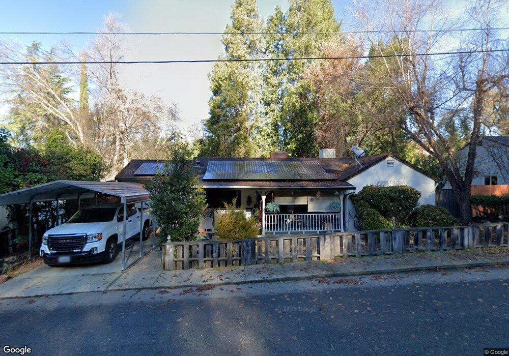
1355 Martin Ln Placerville, CA 95667
Estimated Value: $353,000 - $417,000
2
Beds
1
Bath
1,119
Sq Ft
$333/Sq Ft
Est. Value
About This Home
This home is located at 1355 Martin Ln, Placerville, CA 95667 and is currently estimated at $372,717, approximately $333 per square foot. 1355 Martin Ln is a home located in El Dorado County with nearby schools including El Dorado High School, Country Day Montessori, and El Dorado Adventist School.
Ownership History
Date
Name
Owned For
Owner Type
Purchase Details
Closed on
May 9, 2012
Sold by
Lewin David Lloyd and Lewin Debra Lynn
Bought by
Lewin David Lloyd and Lewin Debra Lynn
Current Estimated Value
Purchase Details
Closed on
Mar 28, 2012
Sold by
Lewin David Lloyd
Bought by
Lewin David Lloyd and Lewis Debra Lynn
Purchase Details
Closed on
Dec 5, 2005
Sold by
Walker Jeanne
Bought by
Lewin David Lloyd and Walker Jeanne
Purchase Details
Closed on
Dec 27, 1993
Sold by
Debler Phillip and Debler Valerie L
Bought by
Walker Desmond T and Walker Jeanne
Create a Home Valuation Report for This Property
The Home Valuation Report is an in-depth analysis detailing your home's value as well as a comparison with similar homes in the area
Home Values in the Area
Average Home Value in this Area
Purchase History
| Date | Buyer | Sale Price | Title Company |
|---|---|---|---|
| Lewin David Lloyd | -- | None Available | |
| Lewin David Lloyd | -- | None Available | |
| Lewin David Lloyd | -- | -- | |
| Walker Desmond T | $115,500 | Fidelity National Title |
Source: Public Records
Tax History Compared to Growth
Tax History
| Year | Tax Paid | Tax Assessment Tax Assessment Total Assessment is a certain percentage of the fair market value that is determined by local assessors to be the total taxable value of land and additions on the property. | Land | Improvement |
|---|---|---|---|---|
| 2025 | $1,699 | $161,387 | $37,675 | $123,712 |
| 2024 | $1,699 | $158,224 | $36,937 | $121,287 |
| 2023 | $1,680 | $155,122 | $36,213 | $118,909 |
| 2022 | $1,657 | $152,081 | $35,503 | $116,578 |
| 2021 | $1,638 | $149,100 | $34,807 | $114,293 |
| 2020 | $1,614 | $147,573 | $34,451 | $113,122 |
| 2019 | $1,595 | $144,680 | $33,776 | $110,904 |
| 2018 | $1,547 | $141,844 | $33,114 | $108,730 |
| 2017 | $1,525 | $139,064 | $32,465 | $106,599 |
| 2016 | $1,502 | $136,338 | $31,829 | $104,509 |
| 2015 | $1,434 | $134,291 | $31,351 | $102,940 |
| 2014 | $1,434 | $131,663 | $30,738 | $100,925 |
Source: Public Records
Map
Nearby Homes
- 3136 Baco Dr
- 1344 Village Ln
- 3419 Eskaton Dr
- 2977 Mosquito Rd
- 678 Main St
- 2940 Anderson Way
- 2921 Miller Way
- 1302 Nicks Ln
- 2655 Mona Dr
- 0 Mona Ave
- 3579 Cedar Ravine Rd
- 3095 Cedar Ravine Rd
- 1522 Jeffrey Ln
- 1030 Lemongrass Ct
- 3153 Cedar Ravine Rd
- 3166 Cedar Ravine Rd
- 2-Acres Homestead Dr
- 0 Trails End Dr Unit 225117516
- 1015 Utah Dr
- 2896 Clay St