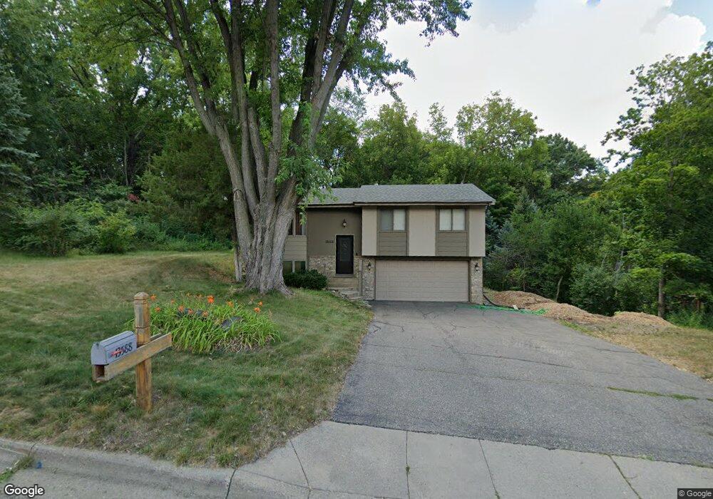
13588 Dan Patch Dr Savage, MN 55378
Estimated Value: $309,000 - $363,000
3
Beds
1
Bath
1,080
Sq Ft
$319/Sq Ft
Est. Value
About This Home
This home is located at 13588 Dan Patch Dr, Savage, MN 55378 and is currently estimated at $344,504, approximately $318 per square foot. 13588 Dan Patch Dr is a home located in Scott County with nearby schools including Eagle Ridge Middle School, Burnsville High School, and Aspen Academy.
Ownership History
Date
Name
Owned For
Owner Type
Purchase Details
Closed on
Jun 29, 2010
Sold by
Sec Of Housing Of Urban Dev
Bought by
Roberts Roman
Current Estimated Value
Home Financials for this Owner
Home Financials are based on the most recent Mortgage that was taken out on this home.
Original Mortgage
$96,080
Outstanding Balance
$64,197
Interest Rate
4.83%
Mortgage Type
New Conventional
Estimated Equity
$280,307
Purchase Details
Closed on
Jul 26, 1999
Sold by
Lindquist James A and Lindquist Kathleen C
Bought by
Kearney Michael J
Create a Home Valuation Report for This Property
The Home Valuation Report is an in-depth analysis detailing your home's value as well as a comparison with similar homes in the area
Home Values in the Area
Average Home Value in this Area
Purchase History
| Date | Buyer | Sale Price | Title Company |
|---|---|---|---|
| Roberts Roman | $120,100 | -- | |
| Kearney Michael J | $134,500 | -- |
Source: Public Records
Mortgage History
| Date | Status | Borrower | Loan Amount |
|---|---|---|---|
| Open | Roberts Roman | $96,080 |
Source: Public Records
Tax History
| Year | Tax Paid | Tax Assessment Tax Assessment Total Assessment is a certain percentage of the fair market value that is determined by local assessors to be the total taxable value of land and additions on the property. | Land | Improvement |
|---|---|---|---|---|
| 2025 | $3,328 | $339,300 | $211,900 | $127,400 |
| 2024 | $3,478 | $314,900 | $180,100 | $134,800 |
| 2023 | $3,474 | $324,400 | $189,600 | $134,800 |
| 2022 | $2,696 | $324,400 | $189,600 | $134,800 |
| 2021 | $2,686 | $245,300 | $144,900 | $100,400 |
| 2020 | $2,532 | $230,600 | $130,200 | $100,400 |
| 2019 | $2,584 | $211,400 | $114,500 | $96,900 |
| 2018 | $2,140 | $0 | $0 | $0 |
| 2016 | $2,172 | $0 | $0 | $0 |
| 2014 | -- | $0 | $0 | $0 |
Source: Public Records
Map
Nearby Homes
- 13605 Dan Patch Ln
- 13521 Dan Patch Dr
- 7507 Taylor Dr
- 13251 Pennsylvania Ave
- 13305 Virginia Ave S
- 13611 Louisiana Ave
- 8295 Foxberry Ct
- 13237 Virginia Ave S
- 13886 Louisiana Ave
- 13232 Virginia Terrace
- 6913 Connelly Cir
- 8316 W 132nd Ln
- 13995 W Virginia Ave
- 8927 W 136th St
- 6436 132nd Ln W
- 13197 Meadow Ln
- 13186 Meadow Ln
- 9125 Windsor Ave
- 14313 Savanna Oaks Dr
- 6056 W 137th St
- 13585 Dan Patch Dr
- 13591 Dan Patch Dr
- 13573 Dan Patch Dr
- 13587 Dan Patch Dr
- 13623 Dan Patch Dr
- 7621 W 136th St
- 13640 Dan Patch Dr
- 13582 Dan Patch Dr
- 7673 W 136th St
- 13601 Dan Patch Ln
- 13567 Dan Patch Dr
- 13600 Dan Patch Ln
- 13651 Dan Patch Dr
- 13549 Dan Patch Dr
- 13664 Dan Patch Dr
- 13559 Dan Patch Dr
- 7721 W 136th St
- 13533 Quebec Ave
- 13541 Quebec Ave
- 13548 Dan Patch Dr
Your Personal Tour Guide
Ask me questions while you tour the home.