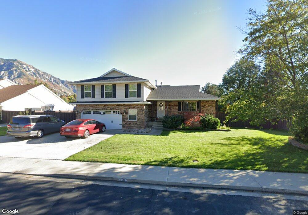
136 E 3800 N Provo, UT 84604
Rock Canyon NeighborhoodEstimated Value: $717,199 - $763,000
4
Beds
4
Baths
2,095
Sq Ft
$352/Sq Ft
Est. Value
About This Home
This home is located at 136 E 3800 N, Provo, UT 84604 and is currently estimated at $737,400, approximately $351 per square foot. 136 E 3800 N is a home located in Utah County with nearby schools including Edgemont School, Centennial Middle School, and Timpview High School.
Ownership History
Date
Name
Owned For
Owner Type
Purchase Details
Closed on
May 28, 2014
Sold by
Horne David W and Horne Michelle C
Bought by
Bernards Samuel and Bernards Julia
Current Estimated Value
Home Financials for this Owner
Home Financials are based on the most recent Mortgage that was taken out on this home.
Original Mortgage
$286,200
Outstanding Balance
$207,612
Interest Rate
3.25%
Mortgage Type
Adjustable Rate Mortgage/ARM
Estimated Equity
$529,788
Purchase Details
Closed on
Sep 17, 1998
Sold by
Horne David W
Bought by
Horne David W and Horne Michelle C
Home Financials for this Owner
Home Financials are based on the most recent Mortgage that was taken out on this home.
Original Mortgage
$196,000
Interest Rate
6.88%
Create a Home Valuation Report for This Property
The Home Valuation Report is an in-depth analysis detailing your home's value as well as a comparison with similar homes in the area
Home Values in the Area
Average Home Value in this Area
Purchase History
| Date | Buyer | Sale Price | Title Company |
|---|---|---|---|
| Bernards Samuel | -- | Access Title Co | |
| Horne David W | -- | -- | |
| Horne David W | -- | -- |
Source: Public Records
Mortgage History
| Date | Status | Borrower | Loan Amount |
|---|---|---|---|
| Open | Bernards Samuel | $286,200 | |
| Previous Owner | Horne David W | $196,000 |
Source: Public Records
Tax History
| Year | Tax Paid | Tax Assessment Tax Assessment Total Assessment is a certain percentage of the fair market value that is determined by local assessors to be the total taxable value of land and additions on the property. | Land | Improvement |
|---|---|---|---|---|
| 2025 | $3,456 | $363,770 | -- | -- |
| 2024 | $3,456 | $340,175 | $0 | $0 |
| 2023 | $3,364 | $326,480 | $0 | $0 |
| 2022 | $3,678 | $359,865 | $0 | $0 |
| 2021 | $2,809 | $479,300 | $204,000 | $275,300 |
| 2020 | $2,750 | $439,900 | $170,000 | $269,900 |
| 2019 | $2,644 | $439,900 | $170,000 | $269,900 |
| 2018 | $2,334 | $393,800 | $159,100 | $234,700 |
| 2017 | $2,199 | $203,940 | $0 | $0 |
| 2016 | $2,152 | $185,955 | $0 | $0 |
| 2015 | $1,889 | $175,835 | $0 | $0 |
| 2014 | $1,843 | $167,860 | $0 | $0 |
Source: Public Records
Map
Nearby Homes
- 3857 N 100 E
- 3588 N 230 E
- 3711 N Canyon Rd
- 3690 N Canyon Rd
- 407 E 3900 Rd N Unit 1
- 407 E 3900 Rd N
- 299 E 4000 N
- 5600 N Canyon Rd
- 4161 N Canyon Rd Unit 2
- 3535 N 160 St W
- 3305 N Shadowbrook Cir
- 158 Woodside Dr
- 404 W 3700 N
- 111 Candlewood Place
- 3240 Shadowbrook Dr
- 3339 N Cottonwood Ln
- 645 Foothill Dr
- 3702 N 920 E
- 3057 N 100 W
- 3013 N 100 W