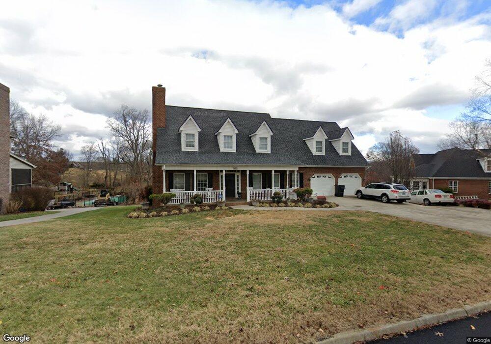
137 Barefoot Landing Dr Blountville, TN 37617
Estimated Value: $562,000 - $714,000
--
Bed
4
Baths
2,941
Sq Ft
$215/Sq Ft
Est. Value
About This Home
This home is located at 137 Barefoot Landing Dr, Blountville, TN 37617 and is currently estimated at $632,176, approximately $214 per square foot. 137 Barefoot Landing Dr is a home located in Sullivan County with nearby schools including Holston Elementary School, Sullivan Central Middle School, and Tri-Cities Christian Academy.
Ownership History
Date
Name
Owned For
Owner Type
Purchase Details
Closed on
Jun 24, 2004
Sold by
Stapleton James C and Stapleton Betty J
Bought by
Jonus Troy A
Current Estimated Value
Home Financials for this Owner
Home Financials are based on the most recent Mortgage that was taken out on this home.
Original Mortgage
$246,800
Outstanding Balance
$122,663
Interest Rate
6.25%
Estimated Equity
$509,513
Purchase Details
Closed on
Jun 4, 1998
Sold by
Paul Darnell James
Bought by
James Stapleton
Create a Home Valuation Report for This Property
The Home Valuation Report is an in-depth analysis detailing your home's value as well as a comparison with similar homes in the area
Home Values in the Area
Average Home Value in this Area
Purchase History
| Date | Buyer | Sale Price | Title Company |
|---|---|---|---|
| Jonus Troy A | $308,500 | -- | |
| James Stapleton | $259,000 | -- |
Source: Public Records
Mortgage History
| Date | Status | Borrower | Loan Amount |
|---|---|---|---|
| Open | James Stapleton | $246,800 |
Source: Public Records
Tax History Compared to Growth
Tax History
| Year | Tax Paid | Tax Assessment Tax Assessment Total Assessment is a certain percentage of the fair market value that is determined by local assessors to be the total taxable value of land and additions on the property. | Land | Improvement |
|---|---|---|---|---|
| 2024 | $2,107 | $84,400 | $6,550 | $77,850 |
| 2023 | $2,031 | $84,400 | $6,550 | $77,850 |
| 2022 | $2,031 | $84,400 | $6,550 | $77,850 |
| 2021 | $2,031 | $84,400 | $6,550 | $77,850 |
| 2020 | $2,104 | $84,400 | $6,550 | $77,850 |
| 2019 | $2,104 | $81,875 | $6,550 | $75,325 |
| 2018 | $2,088 | $81,875 | $6,550 | $75,325 |
| 2017 | $2,088 | $81,875 | $6,550 | $75,325 |
| 2016 | $2,280 | $88,525 | $9,800 | $78,725 |
| 2014 | $2,041 | $88,536 | $0 | $0 |
Source: Public Records
Map
Nearby Homes
- 295 Brown Cir
- 239 Brown Cir
- Tbd Yoakley Rd
- 129 Forest Ln N
- 290 Candy Creek Private Dr
- 156 Forest Ln N
- 164 Forest Ln N
- 148 Forest Ln S
- 205 Grande Harbor Way
- 191 Grande Harbor Way
- 304 Rutledge Ln
- 112 Cardinal Point
- 205 Forest Ct
- 145 Grande Harbor Way
- 225 Forest Ln N
- Tbd Old Muddy Creek Rd
- 780 Hamilton Rd Unit 6
- 780 Hamilton Rd Unit I-4
- 999 Muddy Creek Rd
- 308 Sugar Hollow Trail
- 137 Barefoot Landings Dr
- 133 Barefoot Landing Dr
- 212 Sandy Pointe St
- 212 Sandy Point
- 212 Sandy Point Dr
- 141 Barefoot Landing Dr
- 129 Barefoot Landing Dr
- 129 Barefoot Landings Dr
- 208 Sandy Point Dr
- 208 Sandy Point
- 208 Sandy Pointe St
- 140 Barefoot Landing Dr
- 136 Barefoot Landings Dr
- 140 Barefoot Landings Dr
- LOT 26 Sandy Pointe St
- LOT 43 Sandy Pointe St
- Lot43 Sandy Pointe St
- 30 Sandy Pointe St
- 0 Sandy Pointe St
- 242 Sandy Pointe St