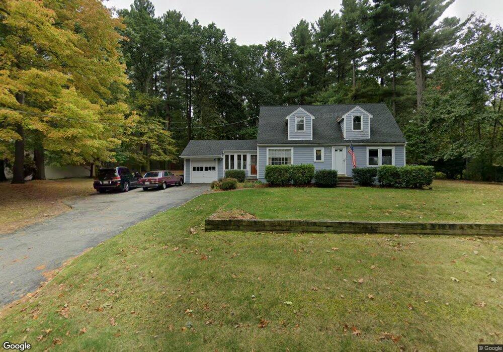
138 High Plain Rd Andover, MA 01810
West Andover NeighborhoodEstimated Value: $745,000 - $941,000
4
Beds
2
Baths
1,638
Sq Ft
$517/Sq Ft
Est. Value
About This Home
This home is located at 138 High Plain Rd, Andover, MA 01810 and is currently estimated at $846,531, approximately $516 per square foot. 138 High Plain Rd is a home located in Essex County with nearby schools including West Elementary School, Andover West Middle School, and Andover High School.
Ownership History
Date
Name
Owned For
Owner Type
Purchase Details
Closed on
Oct 17, 2001
Sold by
Stone Joel D and Stone Angela L
Bought by
Yepez Luis E and Yepez Gisela
Current Estimated Value
Home Financials for this Owner
Home Financials are based on the most recent Mortgage that was taken out on this home.
Original Mortgage
$275,000
Outstanding Balance
$107,881
Interest Rate
6.92%
Mortgage Type
Purchase Money Mortgage
Estimated Equity
$738,650
Purchase Details
Closed on
Jul 16, 1997
Sold by
Kirk Alan J
Bought by
Stone Joel D
Purchase Details
Closed on
Nov 27, 1996
Sold by
Aumais Matthew A
Bought by
Kirk Alan J
Purchase Details
Closed on
Apr 19, 1991
Sold by
Bartoshevich Am Anth
Bought by
Aumais Matthew A
Create a Home Valuation Report for This Property
The Home Valuation Report is an in-depth analysis detailing your home's value as well as a comparison with similar homes in the area
Home Values in the Area
Average Home Value in this Area
Purchase History
| Date | Buyer | Sale Price | Title Company |
|---|---|---|---|
| Yepez Luis E | $400,000 | -- | |
| Yepez Luis E | $400,000 | -- | |
| Stone Joel D | $260,000 | -- | |
| Stone Joel D | $260,000 | -- | |
| Kirk Alan J | $246,000 | -- | |
| Kirk Alan J | $246,000 | -- | |
| Aumais Matthew A | $130,000 | -- | |
| Aumais Matthew A | $130,000 | -- |
Source: Public Records
Mortgage History
| Date | Status | Borrower | Loan Amount |
|---|---|---|---|
| Open | Aumais Matthew A | $275,000 | |
| Closed | Aumais Matthew A | $105,000 |
Source: Public Records
Tax History
| Year | Tax Paid | Tax Assessment Tax Assessment Total Assessment is a certain percentage of the fair market value that is determined by local assessors to be the total taxable value of land and additions on the property. | Land | Improvement |
|---|---|---|---|---|
| 2024 | $9,104 | $706,800 | $430,500 | $276,300 |
| 2023 | $8,703 | $637,100 | $387,700 | $249,400 |
| 2022 | $8,337 | $571,000 | $343,200 | $227,800 |
| 2021 | $7,972 | $521,400 | $312,100 | $209,300 |
| 2020 | $7,646 | $509,400 | $304,600 | $204,800 |
| 2019 | $7,430 | $486,600 | $287,100 | $199,500 |
| 2018 | $7,107 | $454,400 | $270,900 | $183,500 |
| 2017 | $6,793 | $447,500 | $265,500 | $182,000 |
| 2016 | $6,380 | $430,500 | $248,500 | $182,000 |
| 2015 | $6,145 | $410,500 | $238,900 | $171,600 |
Source: Public Records
Map
Nearby Homes
- 54 Birch Rd
- 20 Robert Dr Unit 20
- 6 Exeter Way
- 22 Bobby Jones Dr
- 58 Chandler Rd
- 31 Crenshaw Ln Unit 31
- 37 Crenshaw Ln Unit 37
- 25 Clubview Dr Unit 25
- 241 Lowell St Unit 3
- 4 Weeping Willow Dr
- 5 Weeping Willow Dr
- 2 Weeping Willow Dr
- 40 Chandler Cir
- 9 Oakland Rd
- 29 Westchester Dr
- 21 Clubview Dr Unit 21
- 5 Crestwood Cir
- 0
- 2 Boardwalk Dr
- 10 Dartmouth Rd
- 134 High Plain Rd
- 140 High Plain Rd
- 137 High Plain Rd
- 150 High Plain Rd
- 141 High Plain Rd
- 145 High Plain Rd
- 124 High Plain Rd
- 154 High Plain Rd
- 151 High Plain Rd
- 1 Serenity Ln
- 5 Serenity Ln
- 2 Spencer Ct
- 4 Spencer Ct
- 120 High Plain Rd
- 17 Serenity Ln
- 6 Spencer Ct
- 158 High Plain Rd
- 8 Spencer Ct
- 2 Serenity Ln
- 7 Serenity Ln
Your Personal Tour Guide
Ask me questions while you tour the home.