C
Seller's Agent in 2025
Christine Garstka
Executive Real Estate, Inc.
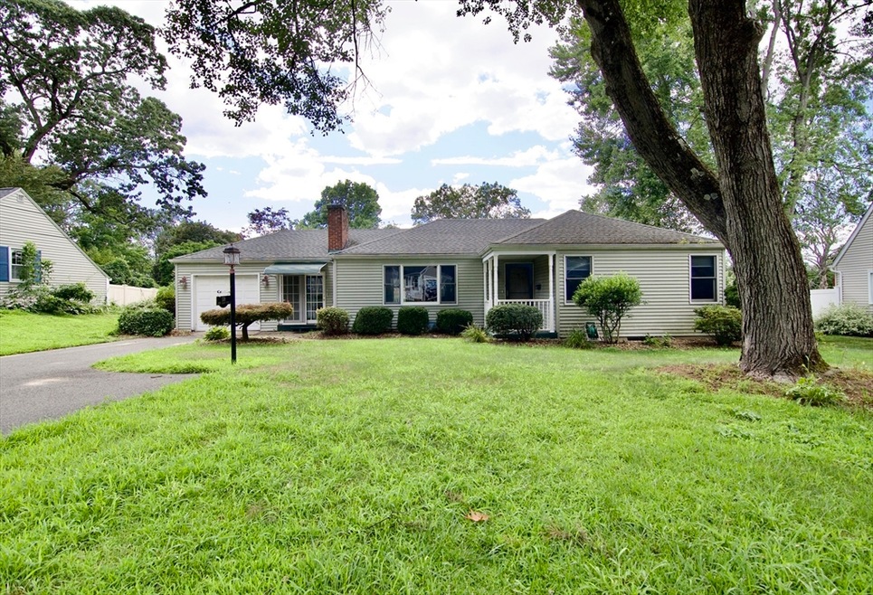


*Final and Best Offers by Monday 7/28 at 3:00pm.* Priced to Sell is this 3 bedroom, 1 bath Ranch in one of Springfield’s most sought after areas. Eat-in Kitchen with white cabinets, granite countertops, stainless steel appliances with breakfast bar that opens to living room. LR offers custom built-in cabinets and hardwood floors. Full bath with Ceramic tile floors, single sink vanity and tub/shower. 3 bedrooms with hardwood floors. Partially finished basement with washer & dryer to remain. Enclosed unheated breezeway adds to the living area leading to one car garage. Deck overlooking private backyard. Newer furnace and brand new hot water tank. This one will not last!!
Last Agent to Sell the Property
Christine Garstka
Executive Real Estate, Inc. Listed on: 07/24/2025

| Date | Type | Sale Price | Title Company |
|---|---|---|---|
| Deed | $309,000 | -- | |
| Land Court Massachusetts | $123,000 | -- | |
| Land Court Massachusetts | $123,000 | -- |
| Date | Status | Loan Amount | Loan Type |
|---|---|---|---|
| Open | $303,403 | FHA | |
| Previous Owner | $110,700 | Purchase Money Mortgage |
| Date | Event | Price | List to Sale | Price per Sq Ft |
|---|---|---|---|---|
| 08/18/2025 08/18/25 | Sold | $309,000 | +10.4% | $286 / Sq Ft |
| 07/30/2025 07/30/25 | Pending | -- | -- | -- |
| 07/24/2025 07/24/25 | For Sale | $279,900 | -- | $259 / Sq Ft |
| Year | Tax Paid | Tax Assessment Tax Assessment Total Assessment is a certain percentage of the fair market value that is determined by local assessors to be the total taxable value of land and additions on the property. | Land | Improvement |
|---|---|---|---|---|
| 2025 | $4,456 | $284,200 | $47,800 | $236,400 |
| 2024 | $4,588 | $285,700 | $47,800 | $237,900 |
| 2023 | $4,471 | $262,200 | $45,600 | $216,600 |
| 2022 | $3,894 | $206,900 | $45,600 | $161,300 |
| 2021 | $3,689 | $195,200 | $41,400 | $153,800 |
| 2020 | $3,508 | $179,600 | $41,400 | $138,200 |
| 2019 | $3,212 | $163,200 | $41,400 | $121,800 |
| 2018 | $3,302 | $167,800 | $41,400 | $126,400 |
| 2017 | $3,079 | $156,600 | $41,400 | $115,200 |
| 2016 | $2,984 | $151,800 | $41,400 | $110,400 |
| 2015 | $2,913 | $148,100 | $41,400 | $106,700 |
C
Seller's Agent in 2025
Christine Garstka
Executive Real Estate, Inc.
R
Buyer's Agent in 2025
Rachel Donermeyer
Executive Real Estate, Inc.
(413) 454-5778
3 in this area
16 Total Sales
Source: MLS Property Information Network (MLS PIN)
MLS Number: 73408848
APN: SPRI-012150-000000-000036
Disclaimer: Certain information contained herein is derived from information provided by parties other than Homes.com. All information provided is deemed reliable, but is not guaranteed to be accurate and should be independently verified.
![]() The property listing data and information, or the Images, set forth herein were provided to MLS Property Information Network, Inc. from third party sources, including sellers, lessors and public records, and were compiled by MLS Property Information Network, Inc. The property listing data and information, and the Images, are for the personal, non-commercial use of consumers having a good faith interest in purchasing or leasing listed properties of the type displayed to them and may not be used for any purpose other than to identify prospective properties which such consumers may have a good faith interest in purchasing or leasing. MLS Property Information Network, Inc. and its subscribers disclaim any and all representations and warranties as to the accuracy of the property listing data and information, or as to the accuracy of any of the Images, set forth herein.
The property listing data and information, or the Images, set forth herein were provided to MLS Property Information Network, Inc. from third party sources, including sellers, lessors and public records, and were compiled by MLS Property Information Network, Inc. The property listing data and information, and the Images, are for the personal, non-commercial use of consumers having a good faith interest in purchasing or leasing listed properties of the type displayed to them and may not be used for any purpose other than to identify prospective properties which such consumers may have a good faith interest in purchasing or leasing. MLS Property Information Network, Inc. and its subscribers disclaim any and all representations and warranties as to the accuracy of the property listing data and information, or as to the accuracy of any of the Images, set forth herein.