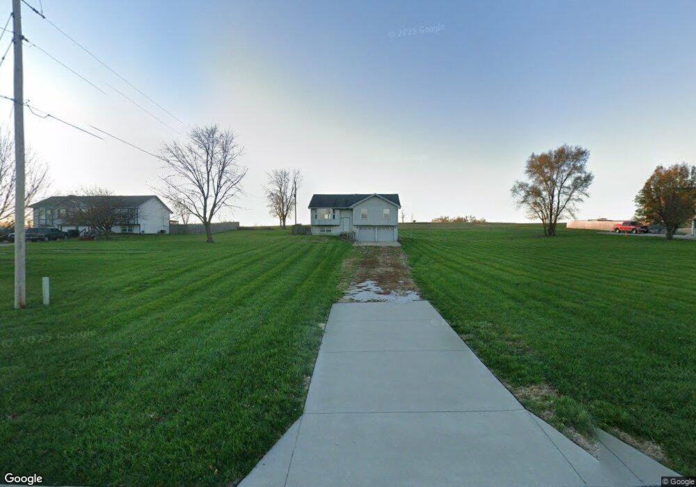
13879 Mcintyre Rd Leavenworth, KS 66048
Estimated Value: $318,000 - $363,000
3
Beds
2
Baths
1,178
Sq Ft
$291/Sq Ft
Est. Value
About This Home
This home is located at 13879 Mcintyre Rd, Leavenworth, KS 66048 and is currently estimated at $343,121, approximately $291 per square foot. 13879 Mcintyre Rd is a home located in Leavenworth County with nearby schools including Lansing Elementary School, Lansing Middle 6-8, and Lansing High 9-12.
Ownership History
Date
Name
Owned For
Owner Type
Purchase Details
Closed on
Aug 1, 1993
Bought by
Price Lori Ann
Current Estimated Value
Home Financials for this Owner
Home Financials are based on the most recent Mortgage that was taken out on this home.
Original Mortgage
$138,400
Outstanding Balance
$101,492
Interest Rate
7.25%
Mortgage Type
New Conventional
Estimated Equity
$241,629
Create a Home Valuation Report for This Property
The Home Valuation Report is an in-depth analysis detailing your home's value as well as a comparison with similar homes in the area
Home Values in the Area
Average Home Value in this Area
Purchase History
| Date | Buyer | Sale Price | Title Company |
|---|---|---|---|
| Price Lori Ann | $86,000 | -- |
Source: Public Records
Mortgage History
| Date | Status | Borrower | Loan Amount |
|---|---|---|---|
| Open | Price Lori Ann | $138,400 | |
| Closed | Price Lori Ann | $120,000 |
Source: Public Records
Tax History Compared to Growth
Tax History
| Year | Tax Paid | Tax Assessment Tax Assessment Total Assessment is a certain percentage of the fair market value that is determined by local assessors to be the total taxable value of land and additions on the property. | Land | Improvement |
|---|---|---|---|---|
| 2025 | $4,122 | $32,096 | $6,644 | $25,452 |
| 2024 | $3,837 | $30,862 | $7,756 | $23,106 |
| 2023 | $3,837 | $29,675 | $7,756 | $21,919 |
| 2022 | $3,689 | $26,977 | $5,360 | $21,617 |
| 2021 | $3,264 | $22,746 | $4,471 | $18,275 |
| 2020 | $3,128 | $21,459 | $4,306 | $17,153 |
| 2019 | $3,020 | $20,700 | $3,961 | $16,739 |
| 2018 | $2,887 | $19,814 | $4,380 | $15,434 |
| 2017 | $2,813 | $19,271 | $4,380 | $14,891 |
| 2016 | $2,815 | $19,271 | $4,380 | $14,891 |
| 2015 | $2,681 | $18,425 | $4,380 | $14,045 |
| 2014 | $2,548 | $17,888 | $4,380 | $13,508 |
Source: Public Records
Map
Nearby Homes
- 13965 Mc Intyre Rd
- 24431 139th St
- 13788 McIntyre2 Rd
- 13788 McIntyre1 Rd
- 13788 Mcintyre Rd
- Lot 2 139th St
- 23802 140th St
- 131 Rock Creek Loop
- 705 Rock Creek Dr
- 115 W Gilman Rd
- 875 Clearview Dr
- 833 Rock Creek Dr
- 1221 S Desoto Rd
- 24131 126th St
- 901 S Main St
- 922 Southfork St
- 722 Bittersweet Rd
- 811 4-H Rd
- 624 S Bittersweet Ln
- 104 Olive St
- 13877 Mcintyre Rd
- 13881 Mcintyre Rd
- 13883 Mcintyre Rd
- 13794 Mcintyre Rd
- 13885 Mcintyre Rd
- 13887 Mcintyre Rd
- 13889 Mcintyre Rd
- 24417 139th St
- 13965 Mcintyre Rd
- 23577 139th St
- 13968 Mcintyre Rd
- 24511 139th St
- 24132 139th St
- 24481 139th St
- 13697 Mcintyre Rd
- 0 Mcintyre Rd Unit 1714253
- Lot 3 Mcintyre Rd
- Lot 2 Mcintyre Rd
- 0 Mcintyre Rd Unit 1782188
- 13992 Mcintyre Rd