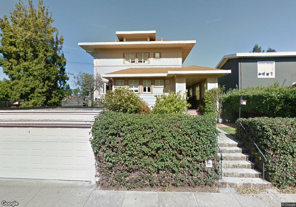
139 Hillcrest Rd Berkeley, CA 94705
Claremont NeighborhoodEstimated Value: $2,907,000 - $3,090,000
4
Beds
3
Baths
2,890
Sq Ft
$1,036/Sq Ft
Est. Value
About This Home
This home is located at 139 Hillcrest Rd, Berkeley, CA 94705 and is currently estimated at $2,993,229, approximately $1,035 per square foot. 139 Hillcrest Rd is a home located in Alameda County with nearby schools including John Muir Elementary School, Emerson Elementary School, and Malcolm X Elementary School.
Ownership History
Date
Name
Owned For
Owner Type
Purchase Details
Closed on
Jul 30, 2021
Sold by
Alberti William G and Alberti Family Trust
Bought by
Alberti William G and Alberti Family Trust
Current Estimated Value
Home Financials for this Owner
Home Financials are based on the most recent Mortgage that was taken out on this home.
Original Mortgage
$822,375
Outstanding Balance
$625,797
Interest Rate
2.3%
Mortgage Type
New Conventional
Estimated Equity
$2,367,432
Purchase Details
Closed on
Oct 1, 2018
Sold by
Alberti William G
Bought by
Alberti William G and Wga Survivor S Trust
Purchase Details
Closed on
May 26, 2017
Sold by
Cannon Lawrence Saville and The Elizabeth Bess Cannon Hall
Bought by
Alberti William G
Create a Home Valuation Report for This Property
The Home Valuation Report is an in-depth analysis detailing your home's value as well as a comparison with similar homes in the area
Home Values in the Area
Average Home Value in this Area
Purchase History
| Date | Buyer | Sale Price | Title Company |
|---|---|---|---|
| Alberti William G | -- | Mortgage Connect Lp | |
| Alberti William G | -- | None Available | |
| Alberti William G | $2,100,000 | Placer Title Company |
Source: Public Records
Mortgage History
| Date | Status | Borrower | Loan Amount |
|---|---|---|---|
| Open | Alberti William G | $822,375 |
Source: Public Records
Tax History
| Year | Tax Paid | Tax Assessment Tax Assessment Total Assessment is a certain percentage of the fair market value that is determined by local assessors to be the total taxable value of land and additions on the property. | Land | Improvement |
|---|---|---|---|---|
| 2025 | $36,330 | $2,437,175 | $731,152 | $1,706,023 |
| 2024 | $36,330 | $2,389,400 | $716,820 | $1,672,580 |
| 2023 | $35,552 | $2,342,550 | $702,765 | $1,639,785 |
| 2022 | $35,119 | $2,296,622 | $688,986 | $1,607,636 |
| 2021 | $35,241 | $2,251,598 | $675,479 | $1,576,119 |
| 2020 | $33,479 | $2,228,520 | $668,556 | $1,559,964 |
| 2019 | $32,295 | $2,184,840 | $655,452 | $1,529,388 |
| 2018 | $31,776 | $2,142,000 | $642,600 | $1,499,400 |
| 2017 | $6,815 | $137,106 | $94,432 | $42,674 |
| 2016 | $6,320 | $134,417 | $92,580 | $41,837 |
| 2015 | $6,177 | $132,399 | $91,190 | $41,209 |
| 2014 | $5,956 | $129,805 | $89,404 | $40,401 |
Source: Public Records
Map
Nearby Homes
- 204 El Camino Real
- 2962 Piedmont Ave
- 6189 Margarido Dr
- 6100 Chabot Rd
- 5936 Broadway
- 5941 Keith Ave
- 1488 Alvarado Rd
- 641 Alvarado Rd
- 360 Alcatraz Ave
- 0 Tunnel Rd
- 5668 Buena Vista Ave
- 45 Vicente Rd
- 2477 Prince St
- 5883 Margarido Dr
- 2817 Palm Ct
- 6446 Colby St
- 190 Stonewall Rd
- 0 Gravatt Dr Unit 41122154
- 2 Gravatt Dr
- 5416 Golden Gate Ave
- 143 Hillcrest Rd
- 125 Hillcrest Rd
- 145 Hillcrest Rd
- 56 The Uplands
- 60 The Uplands
- 52 The Uplands
- 151 Hillcrest Rd
- 2 Eucalyptus Rd
- 142 Hillcrest Rd
- 115 Hillcrest Rd
- 50 The Uplands
- 64 The Uplands
- 152 Hillcrest Rd
- 42 The Uplands
- 156 Hillcrest Rd
- 1 Eucalyptus Rd
- 109 Hillcrest Rd
- 70 The Uplands
- 38 The Uplands
- 158 Hillcrest Rd
Your Personal Tour Guide
Ask me questions while you tour the home.