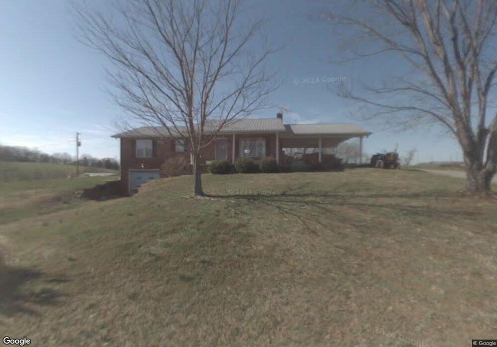
139 Shelton Rd Limestone, TN 37681
Estimated Value: $352,000 - $566,000
Studio
2
Baths
1,372
Sq Ft
$358/Sq Ft
Est. Value
About This Home
This home is located at 139 Shelton Rd, Limestone, TN 37681 and is currently estimated at $490,566, approximately $357 per square foot. 139 Shelton Rd is a home located in Washington County with nearby schools including West View School and David Crockett High School.
Ownership History
Date
Name
Owned For
Owner Type
Purchase Details
Closed on
Aug 13, 2024
Sold by
Pearson Starr
Bought by
Pearson Starr and Pearson David Dean
Current Estimated Value
Purchase Details
Closed on
Jan 20, 2004
Sold by
Hylton Ben M and Hylton Gloria M
Bought by
Hylton Timothy L
Create a Home Valuation Report for This Property
The Home Valuation Report is an in-depth analysis detailing your home's value as well as a comparison with similar homes in the area
Purchase History
| Date | Buyer | Sale Price | Title Company |
|---|---|---|---|
| Pearson Starr | -- | None Listed On Document | |
| Pearson Starr | -- | None Listed On Document | |
| Hylton Timothy L | $35,000 | -- | |
| Hylton Timothy L | $5,000 | -- |
Source: Public Records
Tax History
| Year | Tax Paid | Tax Assessment Tax Assessment Total Assessment is a certain percentage of the fair market value that is determined by local assessors to be the total taxable value of land and additions on the property. | Land | Improvement |
|---|---|---|---|---|
| 2025 | $1,706 | $99,750 | $17,225 | $82,525 |
| 2024 | $1,706 | $99,750 | $17,225 | $82,525 |
| 2022 | $267 | $12,400 | $11,025 | $1,375 |
| 2021 | $267 | $12,400 | $11,025 | $1,375 |
| 2020 | $267 | $12,400 | $11,025 | $1,375 |
| 2019 | $284 | $12,400 | $11,025 | $1,375 |
| 2018 | $284 | $11,950 | $11,175 | $775 |
| 2017 | $284 | $11,950 | $11,175 | $775 |
| 2016 | $284 | $11,950 | $11,175 | $775 |
| 2015 | $237 | $11,950 | $11,175 | $775 |
| 2014 | $237 | $11,950 | $11,175 | $775 |
Source: Public Records
Map
Nearby Homes
- 286 Brobeck Hill Rd
- 1435 Bailey Bridge Rd
- 370 Laws Rd
- Lot-3 Bailey Bridge Rd
- Lot-4 Bailey Bridge Rd
- 185 Lester Snapp Rd Unit 2
- 15.59 Ac Lester Snapp Rd
- 185 Lester Snapp Rd Unit Lot 1
- 289 Bill Mauk Rd
- 290 Bill Mauk Rd
- 290 Bill Mauk Rd
- 2035 Highway 107
- 1576 Corby Bridge Rd
- 103 Lilly Painter Rd
- 2904 Highway 107
- 2851 Tennessee 107
- 1320 Corby Bridge Rd
- 489 Bill West Rd
- 269 Oklahoma Rd
- 170 John Mathews Rd
- 202 Shelton Rd
- 213 Shelton Rd
- 134 Shelton Rd
- 118 Humphreys Rd
- 1615 Bailey Bridge Rd
- 1615 Bailey Bridge Rd
- 104 Humphreys Rd Unit C
- 219 Laws Rd
- 208 Laws Rd
- 191 Humphreys Rd
- 1515 Bailey Bridge Rd
- 202 & 200 Lola Humphreys Rd
- 233 Lola Humphreys Rd
- 00 Lola Humphreys Rd
- ----- Lola Humphreys Rd
- 200 Lola Humphreys Rd
- 1749 Bailey Bridge Rd
- 250 Charles Humphreys Rd
- 203 Lola Humphreys Rd
- 210 Charles Humphreys Rd
Your Personal Tour Guide
Ask me questions while you tour the home.