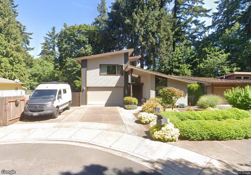
1393 Buck St West Linn, OR 97068
Bolton NeighborhoodEstimated Value: $804,257 - $958,000
4
Beds
3
Baths
2,717
Sq Ft
$326/Sq Ft
Est. Value
About This Home
This home is located at 1393 Buck St, West Linn, OR 97068 and is currently estimated at $884,564, approximately $325 per square foot. 1393 Buck St is a home located in Clackamas County with nearby schools including Bolton Primary School, West Linn High School, and Clackamas Academy of Industrial Sciences (CAIS).
Ownership History
Date
Name
Owned For
Owner Type
Purchase Details
Closed on
Mar 29, 2010
Sold by
Prairie View Homes Llc
Bought by
Pothast Kurt A and Pothast Wendy K
Current Estimated Value
Home Financials for this Owner
Home Financials are based on the most recent Mortgage that was taken out on this home.
Original Mortgage
$352,000
Outstanding Balance
$231,210
Interest Rate
4.88%
Mortgage Type
New Conventional
Estimated Equity
$653,354
Purchase Details
Closed on
Apr 28, 2008
Sold by
Smith Gladys Sue Edens
Bought by
Prairie View Homes Llc
Home Financials for this Owner
Home Financials are based on the most recent Mortgage that was taken out on this home.
Original Mortgage
$432,191
Interest Rate
5.81%
Mortgage Type
Purchase Money Mortgage
Create a Home Valuation Report for This Property
The Home Valuation Report is an in-depth analysis detailing your home's value as well as a comparison with similar homes in the area
Home Values in the Area
Average Home Value in this Area
Purchase History
| Date | Buyer | Sale Price | Title Company |
|---|---|---|---|
| Pothast Kurt A | $440,000 | Fidelity Natl Title Co Of Or | |
| Prairie View Homes Llc | $183,000 | Pacific Nw Title |
Source: Public Records
Mortgage History
| Date | Status | Borrower | Loan Amount |
|---|---|---|---|
| Open | Pothast Kurt A | $352,000 | |
| Previous Owner | Prairie View Homes Llc | $432,191 |
Source: Public Records
Tax History Compared to Growth
Tax History
| Year | Tax Paid | Tax Assessment Tax Assessment Total Assessment is a certain percentage of the fair market value that is determined by local assessors to be the total taxable value of land and additions on the property. | Land | Improvement |
|---|---|---|---|---|
| 2025 | $9,472 | $491,479 | -- | -- |
| 2024 | $9,117 | $477,165 | -- | -- |
| 2023 | $9,117 | $463,267 | $0 | $0 |
| 2022 | $8,605 | $449,774 | $0 | $0 |
| 2021 | $8,169 | $436,674 | $0 | $0 |
| 2020 | $8,224 | $423,956 | $0 | $0 |
| 2019 | $7,843 | $411,608 | $0 | $0 |
| 2018 | $7,493 | $399,619 | $0 | $0 |
| 2017 | $7,143 | $387,980 | $0 | $0 |
| 2016 | $6,812 | $376,680 | $0 | $0 |
| 2015 | $6,484 | $365,709 | $0 | $0 |
| 2014 | $6,136 | $355,057 | $0 | $0 |
Source: Public Records
Map
Nearby Homes
- 5910 W A St
- 1954 Buck St
- 6345 Caufield St
- 6403 Tompkins Ct
- 5687 River St
- 5128 Firwood Dr
- 20930 Fawn Ct Unit 26
- 5219 Summit St
- 19697 SE Cottonwood St
- 2488 Tulane St
- 19575 River Rd Unit 53
- 5062 Prospect St
- 5390 Grove St
- 4973 Summit St
- 2700 Underhill Ln Unit 1
- 19503 SE Kay St
- 22691 Oregon City Loop
- 2764 Ridge Ln
- 4050 Serango Ct
- 5089 Territorial Dr