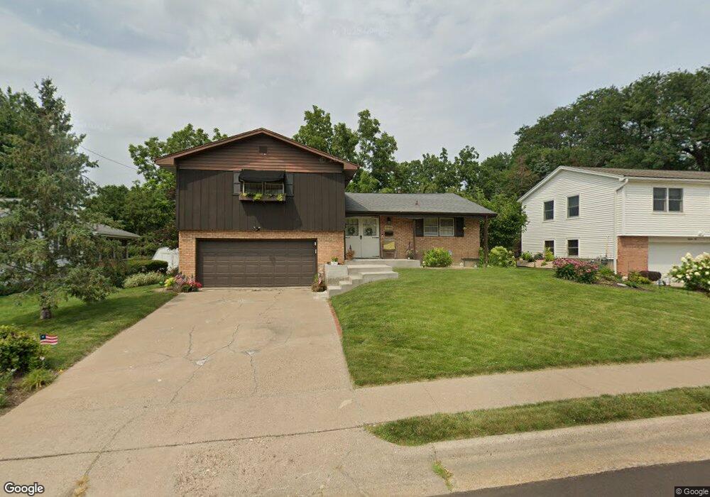
1396 Tomahawk Dr Dubuque, IA 52003
Estimated Value: $258,267 - $295,000
3
Beds
3
Baths
1,536
Sq Ft
$181/Sq Ft
Est. Value
About This Home
This home is located at 1396 Tomahawk Dr, Dubuque, IA 52003 and is currently estimated at $278,567, approximately $181 per square foot. 1396 Tomahawk Dr is a home located in Dubuque County with nearby schools including Bryant Elementary School, George Washington Middle School, and Dubuque Senior High School.
Ownership History
Date
Name
Owned For
Owner Type
Purchase Details
Closed on
Aug 6, 2013
Sold by
Hanley Thomas W
Bought by
Hanley Cynthia A
Current Estimated Value
Purchase Details
Closed on
Mar 9, 2011
Sold by
White Miriam I
Bought by
U S Bank N A and Miriam I White Restatement Of Trust
Create a Home Valuation Report for This Property
The Home Valuation Report is an in-depth analysis detailing your home's value as well as a comparison with similar homes in the area
Purchase History
| Date | Buyer | Sale Price | Title Company |
|---|---|---|---|
| Hanley Cynthia A | -- | None Available | |
| U S Bank N A | -- | None Available |
Source: Public Records
Tax History
| Year | Tax Paid | Tax Assessment Tax Assessment Total Assessment is a certain percentage of the fair market value that is determined by local assessors to be the total taxable value of land and additions on the property. | Land | Improvement |
|---|---|---|---|---|
| 2025 | $3,054 | $255,600 | $44,600 | $211,000 |
| 2024 | $31 | $236,300 | $41,100 | $195,200 |
| 2023 | $3,054 | $236,300 | $41,100 | $195,200 |
| 2022 | $3,002 | $190,510 | $39,270 | $151,240 |
| 2021 | $3,002 | $190,510 | $39,270 | $151,240 |
| 2020 | $2,950 | $174,680 | $39,270 | $135,410 |
| 2019 | $2,958 | $174,680 | $39,270 | $135,410 |
| 2018 | $2,908 | $167,590 | $39,270 | $128,320 |
| 2017 | $2,840 | $167,590 | $39,270 | $128,320 |
| 2016 | $2,778 | $155,600 | $39,270 | $116,330 |
| 2015 | $2,778 | $155,600 | $39,270 | $116,330 |
| 2014 | $2,662 | $153,320 | $39,270 | $114,050 |
Source: Public Records
Map
Nearby Homes
- 1280 S Grandview Ave
- 935 Indian Ridge
- 1047 Shady Oaks Dr
- 966 Victoria St
- 1725 Plymouth Ct
- 626 Bradley St
- 1025 Carmel Dr
- LOT 2-2 Kelly Ln
- 170 S Hill St
- 255 S Main St
- 1830 Links Glen Dr
- 1735 Creek Wood Dr
- 200 S Main St
- 10 Main St
- Lot 128 Edenbrook Ln
- Lot 126 Edenbrook Ln
- Lot 125 Edenbrook Ln
- Lot 130 Edenbrook Ln
- Lot 127 Edenbrook Ln
- Lot 35 Fieldstone Ct
- 1410 Tomahawk Dr
- 1395 Oeth Ct
- 1385 Oeth Ct
- 1432 Tomahawk Dr
- 1376 Tomahawk Dr
- 1375 Oeth Ct
- 1407 Tomahawk Dr
- 1387 Tomahawk Dr
- 1385 Tomahawk Dr
- 1405 Oeth Ct
- 1371 Tomahawk Dr
- 1358 Tomahawk Dr
- 1365 Oeth Ct
- 1429 Tomahawk Dr
- 1449 Tomahawk Dr
- 1415 Oeth Ct
- 1355 Oeth Ct
- 1380 Oeth Ct
- 1353 Tomahawk Dr
- 1342 Tomahawk Dr
Your Personal Tour Guide
Ask me questions while you tour the home.