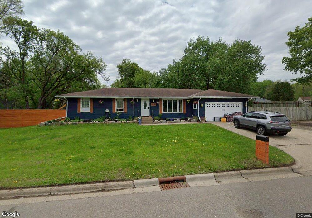
1399 Oakdale Ave Saint Paul, MN 55118
Estimated Value: $373,000 - $411,000
4
Beds
1
Bath
1,488
Sq Ft
$269/Sq Ft
Est. Value
About This Home
This home is located at 1399 Oakdale Ave, Saint Paul, MN 55118 and is currently estimated at $399,736, approximately $268 per square foot. 1399 Oakdale Ave is a home located in Dakota County with nearby schools including Garlough Environmental Magnet, Heritage E-STEM Magnet School, and Two Rivers High School.
Ownership History
Date
Name
Owned For
Owner Type
Purchase Details
Closed on
Mar 2, 2018
Sold by
Arns Inc
Bought by
Loomis Alexander James and Loomis Laureen Sue
Current Estimated Value
Home Financials for this Owner
Home Financials are based on the most recent Mortgage that was taken out on this home.
Original Mortgage
$205,487
Interest Rate
4.46%
Mortgage Type
New Conventional
Purchase Details
Closed on
Sep 7, 2017
Sold by
Christiana Trust
Bought by
Arns Inc
Purchase Details
Closed on
Feb 4, 2016
Sold by
Cunningham Margaret A
Bought by
Christiana Trust
Purchase Details
Closed on
Jul 5, 2001
Sold by
Estate Of Marjorie A Hathaway David
Bought by
Cunningham Thomas L and Cunningham Margaret A
Create a Home Valuation Report for This Property
The Home Valuation Report is an in-depth analysis detailing your home's value as well as a comparison with similar homes in the area
Home Values in the Area
Average Home Value in this Area
Purchase History
| Date | Buyer | Sale Price | Title Company |
|---|---|---|---|
| Loomis Alexander James | $163,318 | Premium Title Services Inc | |
| Arns Inc | -- | None Available | |
| Christiana Trust | $173,700 | None Available | |
| Cunningham Thomas L | $14,200 | -- |
Source: Public Records
Mortgage History
| Date | Status | Borrower | Loan Amount |
|---|---|---|---|
| Previous Owner | Loomis Alexander James | $205,487 |
Source: Public Records
Tax History Compared to Growth
Tax History
| Year | Tax Paid | Tax Assessment Tax Assessment Total Assessment is a certain percentage of the fair market value that is determined by local assessors to be the total taxable value of land and additions on the property. | Land | Improvement |
|---|---|---|---|---|
| 2024 | $4,814 | $372,100 | $108,500 | $263,600 |
| 2023 | $4,814 | $390,200 | $114,900 | $275,300 |
| 2022 | $4,026 | $358,100 | $114,500 | $243,600 |
| 2021 | $3,290 | $313,200 | $99,500 | $213,700 |
| 2020 | $2,396 | $259,600 | $92,900 | $166,700 |
| 2019 | $3,546 | $174,700 | $88,500 | $86,200 |
| 2018 | $3,539 | $245,800 | $82,800 | $163,000 |
| 2017 | $4,663 | $242,100 | $78,800 | $163,300 |
| 2016 | $3,812 | $226,400 | $71,700 | $154,700 |
| 2015 | $3,794 | $189,480 | $64,041 | $125,439 |
| 2014 | -- | $182,504 | $59,024 | $123,480 |
| 2013 | -- | $171,386 | $53,905 | $117,481 |
Source: Public Records
Map
Nearby Homes
- 1523 Traverse Ln
- 1520 Traverse Ln
- 1522 Traverse Ln
- 1524 Traverse Ln
- 360 Trenton Ln
- 1532 Trellis Ln
- 1526 Traverse Ln
- Bayfield Plan at Thompson Square East
- Capri Plan at Thompson Square East
- 1531 Traverse Ln
- Hayward Plan at Thompson Square East
- Barcelona Plan at Thompson Square East
- Athens II Plan at Thompson Square East
- Athens Plan at Thompson Square East
- 1530 Trellis Ln
- 1534 Trellis Ln
- 1536 Trellis Ln
- 1538 Trellis Ln
- 1540 Trellis Ln
- 203 Moreland Ave E
- 1399 1399 Oakdale-Avenue-
- 1394 Oakdale Ave
- 1394 Oakdale Ave
- 1411 Oakdale Ave
- 1390 Carrie St
- 1406 Carrie St
- 1380 Carrie St
- xxx Oakdale Ave
- 1394 1394 Oakdale-Avenue-
- 1420 Carrie St
- 1420 Carrie St
- 1431 Oakdale Ave
- 353 Oakdale Ct
- 1428 Carrie St
- 314 Emerson Ave E
- 350 Oakdale Ct
- 1375 Oakdale Ave
- 1375 1375 Oakdale Ave
- 304 Emerson Ave E
- 372 372 Rehnberg-Place-