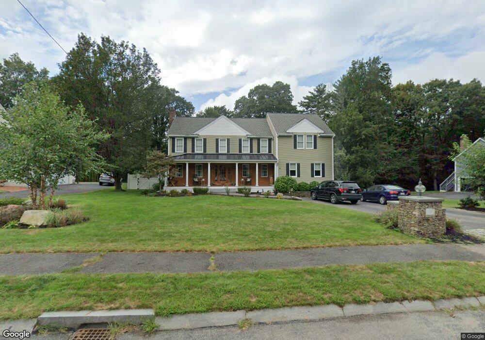
14 King Philip Rd Franklin, MA 02038
Estimated Value: $876,599 - $1,085,000
3
Beds
3
Baths
2,940
Sq Ft
$331/Sq Ft
Est. Value
About This Home
This home is located at 14 King Philip Rd, Franklin, MA 02038 and is currently estimated at $974,400, approximately $331 per square foot. 14 King Philip Rd is a home located in Norfolk County with nearby schools including Gerald M. Parmenter Elementary School, Remington Middle School, and Franklin High School.
Ownership History
Date
Name
Owned For
Owner Type
Purchase Details
Closed on
Oct 20, 2020
Sold by
Leland Ricky A and Leland Barbara
Bought by
Downie James M and Downie Shannon
Current Estimated Value
Home Financials for this Owner
Home Financials are based on the most recent Mortgage that was taken out on this home.
Original Mortgage
$576,000
Outstanding Balance
$511,387
Interest Rate
2.8%
Mortgage Type
New Conventional
Estimated Equity
$463,013
Purchase Details
Closed on
Apr 26, 2002
Sold by
Bean Mark E and Bean Elisa E
Bought by
Leland Ricky A and Leland Barbara
Home Financials for this Owner
Home Financials are based on the most recent Mortgage that was taken out on this home.
Original Mortgage
$351,900
Interest Rate
7.05%
Mortgage Type
Purchase Money Mortgage
Purchase Details
Closed on
May 16, 1997
Sold by
Sherbrook Woods Corp
Bought by
Bean Mark E and Bean Elisa E
Home Financials for this Owner
Home Financials are based on the most recent Mortgage that was taken out on this home.
Original Mortgage
$197,600
Interest Rate
8.12%
Mortgage Type
Purchase Money Mortgage
Create a Home Valuation Report for This Property
The Home Valuation Report is an in-depth analysis detailing your home's value as well as a comparison with similar homes in the area
Purchase History
| Date | Buyer | Sale Price | Title Company |
|---|---|---|---|
| Downie James M | $720,000 | None Available | |
| Leland Ricky A | $391,000 | -- | |
| Bean Mark E | $208,000 | -- |
Source: Public Records
Mortgage History
| Date | Status | Borrower | Loan Amount |
|---|---|---|---|
| Open | Downie James M | $576,000 | |
| Previous Owner | Leland Ricky A | $351,900 | |
| Previous Owner | Bean Mark E | $197,600 |
Source: Public Records
Tax History
| Year | Tax Paid | Tax Assessment Tax Assessment Total Assessment is a certain percentage of the fair market value that is determined by local assessors to be the total taxable value of land and additions on the property. | Land | Improvement |
|---|---|---|---|---|
| 2025 | $9,162 | $788,500 | $360,800 | $427,700 |
| 2024 | $9,296 | $788,500 | $360,800 | $427,700 |
| 2023 | $9,114 | $724,500 | $334,800 | $389,700 |
| 2022 | $8,920 | $634,900 | $288,700 | $346,200 |
| 2021 | $8,608 | $587,600 | $277,000 | $310,600 |
| 2020 | $8,356 | $575,900 | $279,800 | $296,100 |
| 2019 | $8,402 | $573,100 | $277,000 | $296,100 |
| 2018 | $7,904 | $539,500 | $274,100 | $265,400 |
| 2017 | $7,990 | $548,000 | $282,600 | $265,400 |
| 2016 | $7,338 | $506,100 | $244,400 | $261,700 |
| 2015 | $7,381 | $497,400 | $235,700 | $261,700 |
| 2014 | $6,907 | $478,000 | $216,300 | $261,700 |
Source: Public Records
Map
Nearby Homes
- 65 Jordan Rd
- 3 Oak View Terrace Unit 3
- 9 Elliot Mills Unit 5
- 8 Elliot Mills Unit 30
- 5 Elliot Mills Unit 3
- 7 Elliot Mills Unit 4
- 10 Elliot Mills Unit 29
- 14 Waites Crossing
- 10 Waites Crossing
- 18 Northern Spy Rd
- 5 Flintlocke Rd
- 19 Waites Crossing
- 28 Waites Crossing
- 13 Waites Crossing
- 22 Waites Crossing
- 9 Waites Crossing
- 62 Uncas Ave Unit 1
- 60 Uncas Ave Unit 1
- 35 Padden Rd
- 50 Reed Fulton Ave Unit Lot 61
Your Personal Tour Guide
Ask me questions while you tour the home.