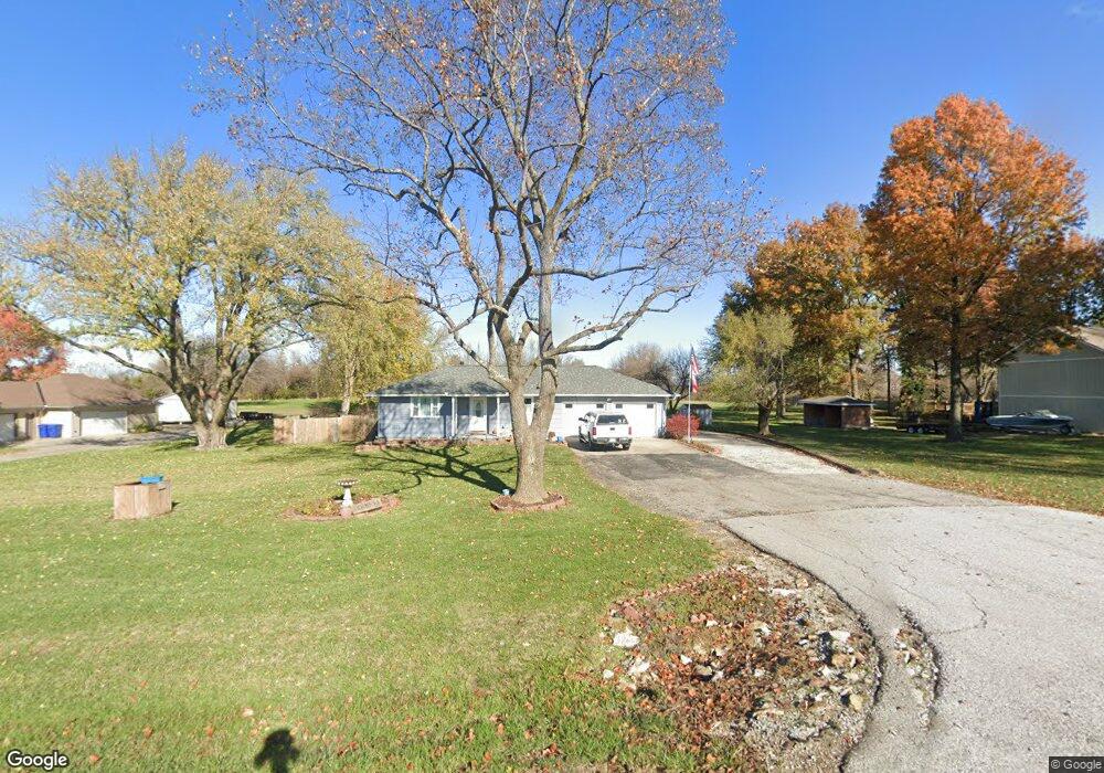
14008 Mcintyre Rd Leavenworth, KS 66048
Estimated Value: $319,785 - $371,000
4
Beds
2
Baths
1,464
Sq Ft
$235/Sq Ft
Est. Value
About This Home
This home is located at 14008 Mcintyre Rd, Leavenworth, KS 66048 and is currently estimated at $344,446, approximately $235 per square foot. 14008 Mcintyre Rd is a home located in Leavenworth County with nearby schools including Lansing Elementary School, Lansing Middle 6-8, and Lansing High 9-12.
Ownership History
Date
Name
Owned For
Owner Type
Purchase Details
Closed on
Jan 1, 1996
Bought by
Tom Darnell E and Darnell Linda J
Current Estimated Value
Home Financials for this Owner
Home Financials are based on the most recent Mortgage that was taken out on this home.
Original Mortgage
$94,950
Outstanding Balance
$51,024
Interest Rate
7.11%
Mortgage Type
VA
Estimated Equity
$293,422
Create a Home Valuation Report for This Property
The Home Valuation Report is an in-depth analysis detailing your home's value as well as a comparison with similar homes in the area
Home Values in the Area
Average Home Value in this Area
Purchase History
| Date | Buyer | Sale Price | Title Company |
|---|---|---|---|
| Tom Darnell E | $115,000 | -- |
Source: Public Records
Mortgage History
| Date | Status | Borrower | Loan Amount |
|---|---|---|---|
| Open | Tom Darnell E | $94,950 | |
| Closed | Tom Darnell E | $15,000 |
Source: Public Records
Tax History Compared to Growth
Tax History
| Year | Tax Paid | Tax Assessment Tax Assessment Total Assessment is a certain percentage of the fair market value that is determined by local assessors to be the total taxable value of land and additions on the property. | Land | Improvement |
|---|---|---|---|---|
| 2025 | $4,344 | $33,754 | $7,190 | $26,564 |
| 2024 | $4,040 | $32,455 | $8,565 | $23,890 |
| 2023 | $4,040 | $31,207 | $8,565 | $22,642 |
| 2022 | $3,885 | $28,370 | $5,728 | $22,642 |
| 2021 | $3,576 | $24,889 | $4,851 | $20,038 |
| 2020 | $3,357 | $23,010 | $4,664 | $18,346 |
| 2019 | $3,238 | $22,176 | $4,319 | $17,857 |
| 2018 | $2,955 | $20,275 | $4,598 | $15,677 |
| 2017 | $2,913 | $19,941 | $4,598 | $15,343 |
| 2016 | $2,872 | $19,655 | $4,598 | $15,057 |
| 2015 | $2,735 | $18,791 | $4,598 | $14,193 |
| 2014 | $2,630 | $18,453 | $4,598 | $13,855 |
Source: Public Records
Map
Nearby Homes
- 13965 Mc Intyre Rd
- 24431 139th St
- 13788 McIntyre2 Rd
- 13788 McIntyre1 Rd
- 13788 Mcintyre Rd
- Lot 2 139th St
- 705 Rock Creek Dr
- 131 Rock Creek Loop
- 23802 140th St
- 833 Rock Creek Dr
- 875 Clearview Dr
- 115 W Gilman Rd
- 1221 S Desoto Rd
- 922 Southfork St
- 901 S Main St
- 811 4-H Rd
- 722 Bittersweet Rd
- 624 S Bittersweet Ln
- 000 4-H Rd
- 24131 126th St
- 13992 Mcintyre Rd
- 14026 Mcintyre Rd
- 13968 Mcintyre Rd
- 14060 Mcintyre Rd
- 13965 Mcintyre Rd
- 14074 Mcintyre Rd
- 24417 139th St
- 24481 139th St
- 14124 Mcintyre Rd
- 24511 139th St
- 13889 Mcintyre Rd
- 14168 Mcintyre Rd
- 14192 Mcintyre Rd
- 13887 Mcintyre Rd
- 14215 Mcintyre Rd
- 13885 Mcintyre Rd
- 14214 Mcintyre Rd
- 13794 Mcintyre Rd
- 24227 139th St
- 23577 139th St