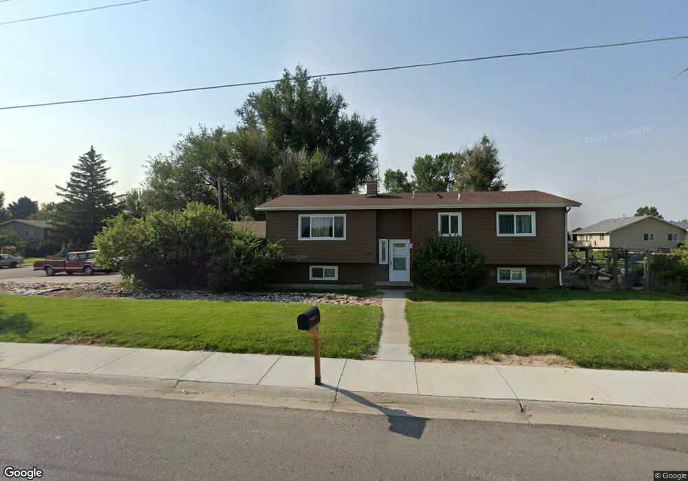
1404 Barrett Rd Billings, MT 59105
Billings Heights NeighborhoodEstimated Value: $335,000 - $386,000
4
Beds
2
Baths
1,184
Sq Ft
$311/Sq Ft
Est. Value
About This Home
This home is located at 1404 Barrett Rd, Billings, MT 59105 and is currently estimated at $368,246, approximately $311 per square foot. 1404 Barrett Rd is a home located in Yellowstone County with nearby schools including Beartooth School, Medicine Crow Middle School, and Skyview High School.
Ownership History
Date
Name
Owned For
Owner Type
Purchase Details
Closed on
Oct 12, 2022
Sold by
Pincolini Steven and Pincolini Elizabeth
Bought by
Steven And Elizabeth Pincolini Living Trust
Current Estimated Value
Purchase Details
Closed on
Dec 18, 2006
Sold by
Brown James R and Brown Bobbi
Bought by
Pincolini Steve and Springman Elizabeth
Purchase Details
Closed on
Nov 8, 2005
Sold by
Peterson Charles J
Bought by
Brown James R and Brown Bobbi
Create a Home Valuation Report for This Property
The Home Valuation Report is an in-depth analysis detailing your home's value as well as a comparison with similar homes in the area
Home Values in the Area
Average Home Value in this Area
Purchase History
| Date | Buyer | Sale Price | Title Company |
|---|---|---|---|
| Steven And Elizabeth Pincolini Living Trust | -- | -- | |
| Pincolini Steve | -- | None Available | |
| Brown James R | $96,500 | None Available |
Source: Public Records
Tax History Compared to Growth
Tax History
| Year | Tax Paid | Tax Assessment Tax Assessment Total Assessment is a certain percentage of the fair market value that is determined by local assessors to be the total taxable value of land and additions on the property. | Land | Improvement |
|---|---|---|---|---|
| 2025 | $4,107 | $377,800 | $69,128 | $308,672 |
| 2024 | $4,107 | $328,000 | $64,108 | $263,892 |
| 2023 | $4,122 | $328,000 | $64,108 | $263,892 |
| 2022 | $2,087 | $221,000 | $0 | $0 |
| 2021 | $3,235 | $220,900 | $0 | $0 |
| 2020 | $2,759 | $225,400 | $0 | $0 |
| 2019 | $2,655 | $225,400 | $0 | $0 |
| 2018 | $2,547 | $211,900 | $0 | $0 |
| 2017 | $1,962 | $211,900 | $0 | $0 |
| 2016 | $2,281 | $197,400 | $0 | $0 |
| 2015 | $2,238 | $197,400 | $0 | $0 |
| 2014 | $2,038 | $94,075 | $0 | $0 |
Source: Public Records
Map
Nearby Homes
- 1320 Mading Dr
- 1961 Bitterroot Dr
- na Hawthorne Ln
- TBD Barrett Rd
- 1203 Peony Dr
- 1512 Mary St
- 1819 Natalie St
- 1982 Sandra Dr
- 1518 S Ping Cir
- 1402 Emma Ave
- 1727 Wicks Ln
- 1327 Tania Cir
- 901 Kale Dr
- 1007 Crist Dr
- 1512 Mustang Valley Dr
- 1403 Eugene Ave
- 1374 Kelsey Ln
- 1353 Tania Cir
- 1106 Victory Ave
- 2542 Kaley Ln
- 1936 Columbine Dr
- 1924 Columbine Dr
- 1941 Columbine Dr
- 1935 Columbine Dr
- 1327 Barrett Rd
- 1920 Columbine Dr
- 1927 Columbine Dr
- 1955 Carroll Heights Cir
- 1919 Columbine Dr
- 1942 Dogwood Dr
- 1916 Columbine Dr
- 1938 Dogwood Dr
- 1950 Carroll Heights Cir
- 1928 Dogwood Dr
- 1326 Bluebell Dr
- 1913 Columbine Dr
- 1920 Dogwood Dr
- 1318 Bluebell Dr
- 1904 Columbine Dr
- 1909 Columbine Dr