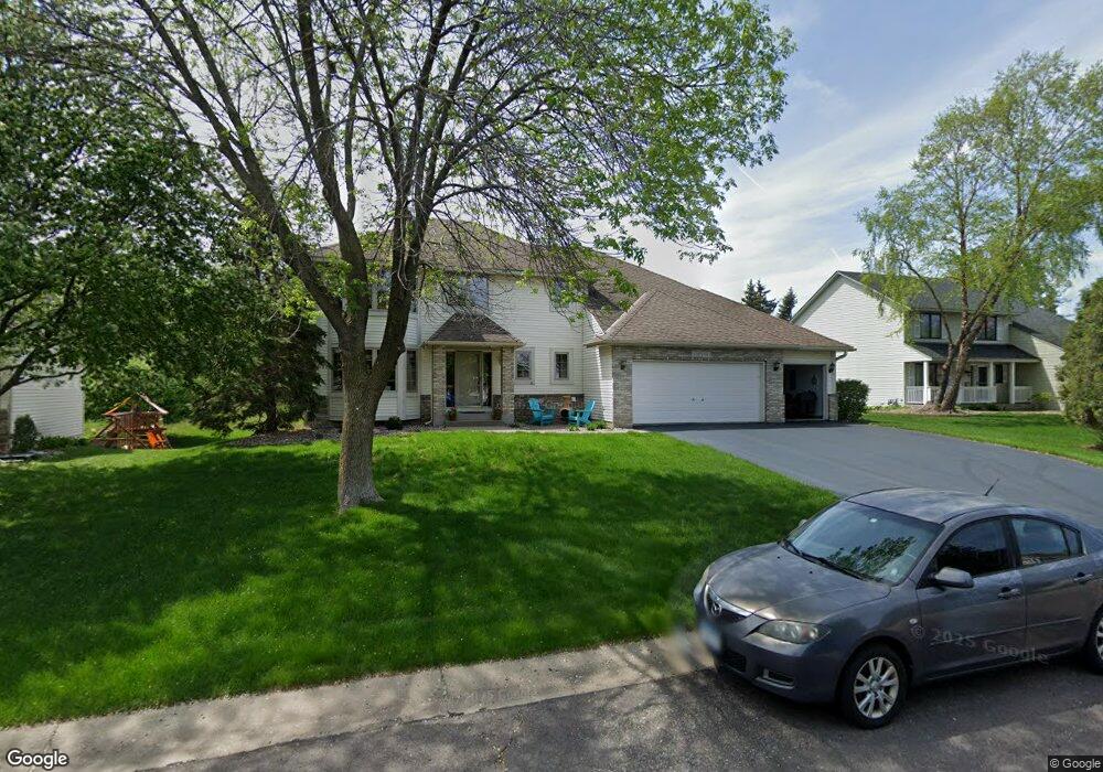
14063 Freeport Ct Saint Paul, MN 55124
Cedar Isle NeighborhoodEstimated Value: $566,927 - $619,000
5
Beds
4
Baths
2,148
Sq Ft
$278/Sq Ft
Est. Value
About This Home
This home is located at 14063 Freeport Ct, Saint Paul, MN 55124 and is currently estimated at $596,982, approximately $277 per square foot. 14063 Freeport Ct is a home located in Dakota County with nearby schools including Greenleaf Elementary School, Falcon Ridge Middle School, and Eastview Senior High School.
Ownership History
Date
Name
Owned For
Owner Type
Purchase Details
Closed on
Mar 22, 2019
Sold by
Teiken Todd G and Teiken Pamela A
Bought by
Messner Joshua Michael and Quamme Tara May
Current Estimated Value
Home Financials for this Owner
Home Financials are based on the most recent Mortgage that was taken out on this home.
Original Mortgage
$373,500
Outstanding Balance
$327,701
Interest Rate
4.3%
Mortgage Type
New Conventional
Estimated Equity
$269,281
Purchase Details
Closed on
May 29, 2002
Sold by
Mazurek John J and Mazurek Cheryl A
Bought by
Teiken Todd G and Teiken Pamela A
Purchase Details
Closed on
Mar 7, 1998
Sold by
Donald L Johnson Homes Inc
Bought by
Mazurek John J
Purchase Details
Closed on
Sep 16, 1997
Sold by
Arcon Development Inc
Bought by
Donald L Johnson Homes Inc
Create a Home Valuation Report for This Property
The Home Valuation Report is an in-depth analysis detailing your home's value as well as a comparison with similar homes in the area
Home Values in the Area
Average Home Value in this Area
Purchase History
| Date | Buyer | Sale Price | Title Company |
|---|---|---|---|
| Messner Joshua Michael | $415,000 | Burnet Title | |
| Teiken Todd G | $319,500 | -- | |
| Mazurek John J | $225,000 | -- | |
| Donald L Johnson Homes Inc | $42,900 | -- |
Source: Public Records
Mortgage History
| Date | Status | Borrower | Loan Amount |
|---|---|---|---|
| Open | Messner Joshua Michael | $373,500 |
Source: Public Records
Tax History Compared to Growth
Tax History
| Year | Tax Paid | Tax Assessment Tax Assessment Total Assessment is a certain percentage of the fair market value that is determined by local assessors to be the total taxable value of land and additions on the property. | Land | Improvement |
|---|---|---|---|---|
| 2024 | $5,950 | $520,600 | $157,600 | $363,000 |
| 2023 | $5,950 | $520,600 | $157,900 | $362,700 |
| 2022 | $4,942 | $497,700 | $157,400 | $340,300 |
| 2021 | $5,296 | $424,500 | $136,700 | $287,800 |
| 2020 | $4,942 | $413,700 | $130,200 | $283,500 |
| 2019 | $4,537 | $403,100 | $124,000 | $279,100 |
| 2018 | $4,619 | $387,300 | $118,100 | $269,200 |
| 2017 | $4,606 | $377,400 | $112,400 | $265,000 |
| 2016 | $4,708 | $358,000 | $107,100 | $250,900 |
| 2015 | $4,466 | $356,468 | $103,624 | $252,844 |
| 2014 | -- | $340,336 | $99,428 | $240,908 |
| 2013 | -- | $308,181 | $90,927 | $217,254 |
Source: Public Records
Map
Nearby Homes
- 14217 Footbridge Way
- 14461 Freesia Way
- 13954 Flagstaff Ct
- 13947 Fleetwood Ave
- 7342 Upper 139th St W
- 14057 Flintwood Ct
- 7291 Upper 136th St W
- 13720 Georgia Dr
- 13868 Glendale Ct
- 14620 Garrett Ave Unit 310
- 13358 Foliage Ave
- 13715 Grafton Ct
- 7577 138th St W
- 7662 142nd St W
- 14242 Glencove Trail
- 6790 132nd St W
- 13973 Falcon Ave
- 6567 133rd St W
- 13912 Farmington Way
- 13135 Gamma Way
- 14047 Freeport Ct
- 14079 Freeport Ct
- 14095 Freeport Ct
- 14072 Freeport Ct
- 14015 Freeport Ct
- 14054 Freeport Ct
- 14038 Freeport Ct
- 14086 Freeport Ct
- 14022 Freeport Ct
- 14111 Freeport Ct
- 14006 Freeport Ct
- 14175 Foxtail Ln
- 14159 Foxtail Ct
- 14165 Foxtail Ln
- 14155 Foxtail Ln
- 14190 Foxtail Ln
- 14169 Freeport Trail
- 7025 142nd St W
- 14180 Foxtail Ln
- 14145 Foxtail Ln