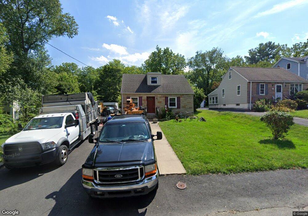
141 Carroll Ave Glenside, PA 19038
Estimated Value: $394,022 - $415,000
3
Beds
2
Baths
1,274
Sq Ft
$318/Sq Ft
Est. Value
About This Home
This home is located at 141 Carroll Ave, Glenside, PA 19038 and is currently estimated at $405,006, approximately $317 per square foot. 141 Carroll Ave is a home located in Montgomery County with nearby schools including Elkins Park School, Cedarbrook Middle School, and Cheltenham High School.
Ownership History
Date
Name
Owned For
Owner Type
Purchase Details
Closed on
Nov 16, 2018
Sold by
Penecale Jeffrey and Penecale Rhonda
Bought by
Penecale Jeffrey
Current Estimated Value
Purchase Details
Closed on
Dec 2, 2009
Sold by
Gibby Deborah E and Gibby Bruce W
Bought by
Penecale Jeffrey and Penecale Rhonda
Home Financials for this Owner
Home Financials are based on the most recent Mortgage that was taken out on this home.
Original Mortgage
$105,000
Outstanding Balance
$68,838
Interest Rate
5%
Estimated Equity
$336,168
Create a Home Valuation Report for This Property
The Home Valuation Report is an in-depth analysis detailing your home's value as well as a comparison with similar homes in the area
Home Values in the Area
Average Home Value in this Area
Purchase History
| Date | Buyer | Sale Price | Title Company |
|---|---|---|---|
| Penecale Jeffrey | -- | None Available | |
| Penecale Jeffrey | $140,000 | None Available |
Source: Public Records
Mortgage History
| Date | Status | Borrower | Loan Amount |
|---|---|---|---|
| Open | Penecale Jeffrey | $105,000 |
Source: Public Records
Tax History Compared to Growth
Tax History
| Year | Tax Paid | Tax Assessment Tax Assessment Total Assessment is a certain percentage of the fair market value that is determined by local assessors to be the total taxable value of land and additions on the property. | Land | Improvement |
|---|---|---|---|---|
| 2025 | $6,511 | $97,490 | $47,200 | $50,290 |
| 2024 | $6,511 | $97,490 | $47,200 | $50,290 |
| 2023 | $6,438 | $97,490 | $47,200 | $50,290 |
| 2022 | $6,327 | $97,490 | $47,200 | $50,290 |
| 2021 | $6,154 | $97,490 | $47,200 | $50,290 |
| 2020 | $5,977 | $97,490 | $47,200 | $50,290 |
| 2019 | $5,857 | $97,490 | $47,200 | $50,290 |
| 2018 | $1,801 | $97,490 | $47,200 | $50,290 |
| 2017 | $5,592 | $97,490 | $47,200 | $50,290 |
| 2016 | $5,554 | $97,490 | $47,200 | $50,290 |
| 2015 | $5,295 | $97,490 | $47,200 | $50,290 |
| 2014 | $5,295 | $97,490 | $47,200 | $50,290 |
Source: Public Records
Map
Nearby Homes
- 56 Chelfield Rd
- 65 Limekiln Pike
- 0 Logan Ave Unit PAMC2112680
- 229 Edge Hill Rd
- 540 Beaver Rd
- 504 Plymouth Rd
- 140 Linden Ave
- 400 W Glenside Ave
- 340 Locust Rd
- 110 Girard Ave
- 162 Logan Ave
- 245 Linden Ave
- 2711 Taft Ave
- 446 Twickenham Rd
- 0 Girard Ave
- 307 Roslyn Ave
- 458 Monroe Ave
- 332 Logan Ave
- 0 Tyson Ave Unit PAMC2112670
- 116 Twining Rd
- 145 Carroll Ave
- 139 Carroll Ave
- 147 Carroll Ave
- 149 Carroll Ave
- 37 Chelfield Rd
- 39 Chelfield Rd
- 35 Chelfield Rd
- 41 Chelfield Rd
- 153 Carroll Ave Unit 27
- 151 Carroll Ave
- 43 Chelfield Rd
- 125 Carroll Ave
- 33 Chelfield Rd
- 155 Carroll Ave
- 123 Carroll Ave
- 31 Chelfield Rd
- 36 Chelfield Rd
- 32 Chelfield Rd
- 40 Chelfield Rd
- 44 Chelfield Rd