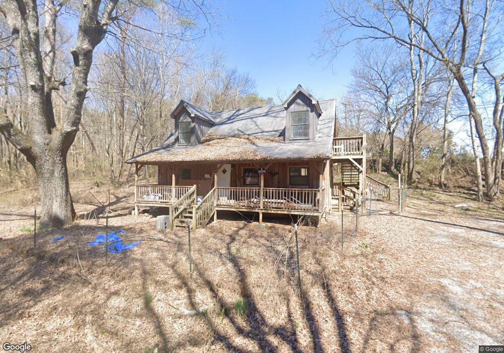
141 Davis St Dunlap, TN 37327
Estimated Value: $144,583 - $162,000
4
Beds
1
Bath
960
Sq Ft
$160/Sq Ft
Est. Value
About This Home
This home is located at 141 Davis St, Dunlap, TN 37327 and is currently estimated at $153,396, approximately $159 per square foot. 141 Davis St is a home located in Sequatchie County with nearby schools including Griffith Elementary School, Sequatchie County Middle School, and Sequatchie County High School.
Ownership History
Date
Name
Owned For
Owner Type
Purchase Details
Closed on
Jun 28, 2024
Sold by
Rivera Steven and Rivera Stephen
Bought by
Lewan Trevor Levi and Lemke Sean Thomas
Current Estimated Value
Purchase Details
Closed on
Jun 26, 2024
Sold by
Land M Keith M and Land George Dwain
Bought by
Rivera Stephen and Rivera Michaela
Purchase Details
Closed on
Sep 30, 2002
Sold by
Land George Dwain
Bought by
Land George Dwain
Purchase Details
Closed on
May 4, 2001
Bought by
Land George Dwain Trustee
Purchase Details
Closed on
Aug 17, 1991
Bought by
Harvey Dennie Curtis and Wife Debbie Inez
Create a Home Valuation Report for This Property
The Home Valuation Report is an in-depth analysis detailing your home's value as well as a comparison with similar homes in the area
Home Values in the Area
Average Home Value in this Area
Purchase History
| Date | Buyer | Sale Price | Title Company |
|---|---|---|---|
| Lewan Trevor Levi | $120,000 | None Listed On Document | |
| Rivera Stephen | -- | None Listed On Document | |
| Land George Dwain | $63,000 | -- | |
| Land George Dwain Trustee | $25,000 | -- | |
| Harvey Dennie Curtis | $12,000 | -- |
Source: Public Records
Tax History
| Year | Tax Paid | Tax Assessment Tax Assessment Total Assessment is a certain percentage of the fair market value that is determined by local assessors to be the total taxable value of land and additions on the property. | Land | Improvement |
|---|---|---|---|---|
| 2025 | $488 | $20,175 | $2,575 | $17,600 |
| 2024 | $488 | $20,175 | $2,575 | $17,600 |
| 2023 | $488 | $20,175 | $2,575 | $17,600 |
| 2022 | $391 | $11,800 | $2,475 | $9,325 |
| 2021 | $333 | $10,200 | $2,475 | $7,725 |
| 2020 | $333 | $10,200 | $2,475 | $7,725 |
| 2019 | $333 | $10,200 | $2,475 | $7,725 |
| 2018 | $322 | $9,950 | $2,475 | $7,475 |
| 2017 | $318 | $9,950 | $2,475 | $7,475 |
| 2016 | $333 | $10,000 | $2,475 | $7,525 |
| 2015 | $333 | $10,000 | $2,475 | $7,525 |
| 2014 | $333 | $10,000 | $2,475 | $7,525 |
Source: Public Records
Map
Nearby Homes
- 11342 Fredonia Rd
- 21 Fredonia Rd
- 0 Fredonia Loop
- 3 Fredonia Rd
- 1 Fredonia Rd
- 2 Boulder Dr
- 2 Fredonia Rd
- 0 State Rt 399 Lot 13
- 159 Poplar St
- 410 Cherry St
- 2000 Fredonia Rd
- 12 Fredonia Rd
- 217 A Day Dream Dr
- 2003 Fredonia Rd
- 267 Williams Rd
- 0 Jericho Rd Unit 1523837
- 0 Jericho Rd Unit RTC3043766
- 0 Jericho Lot 14 Rd
- 0 SE US Hwy 127 Unit 1519993
- 0 SE US Hwy 127 Unit 1519990