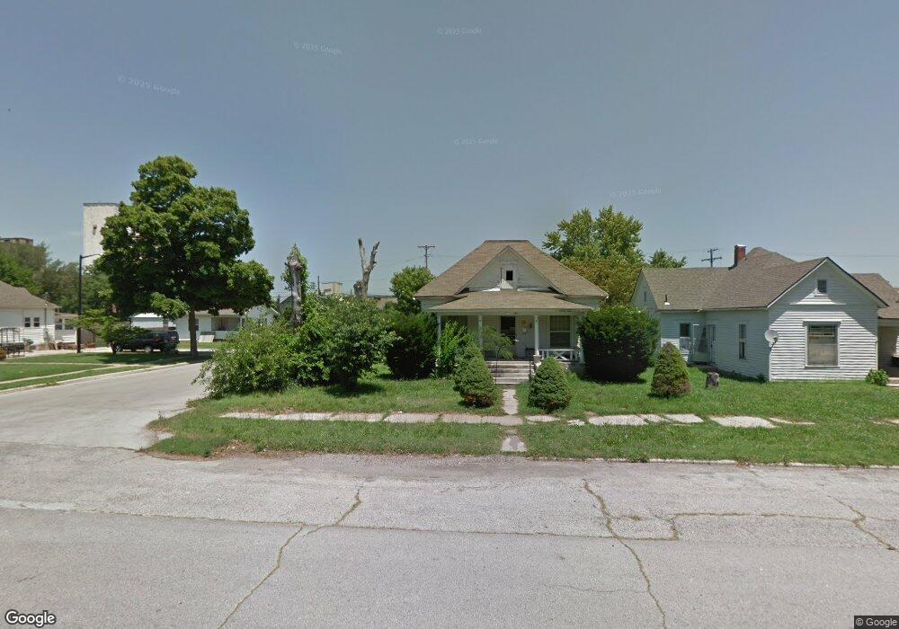
141 W Locust St Aurora, MO 65605
Estimated Value: $130,000 - $150,000
3
Beds
1
Bath
1,190
Sq Ft
$116/Sq Ft
Est. Value
About This Home
This home is located at 141 W Locust St, Aurora, MO 65605 and is currently estimated at $138,030, approximately $115 per square foot. 141 W Locust St is a home located in Lawrence County with nearby schools including Pate Early Childhood Center, Robinson Intermediate School, and Robinson Elementary School.
Ownership History
Date
Name
Owned For
Owner Type
Purchase Details
Closed on
Jun 22, 2020
Sold by
Bowling Russell Dean
Bought by
Watkins Jessica Marie and Bowling Jessica Marie
Current Estimated Value
Purchase Details
Closed on
Jun 19, 2020
Sold by
Peasley Brandin and Peasley Regina
Bought by
Watkins Jessica Marie and Bowling Jessica Marie
Purchase Details
Closed on
Dec 18, 2019
Sold by
Williams Carolyn
Bought by
Bowling Russell Dean
Purchase Details
Closed on
May 16, 2011
Sold by
Walters Sam and Walters Sue
Bought by
Bowling Dean and Bowling Jean
Create a Home Valuation Report for This Property
The Home Valuation Report is an in-depth analysis detailing your home's value as well as a comparison with similar homes in the area
Home Values in the Area
Average Home Value in this Area
Purchase History
| Date | Buyer | Sale Price | Title Company |
|---|---|---|---|
| Watkins Jessica Marie | -- | None Available | |
| Watkins Jessica Marie | -- | None Available | |
| Bowling Russell Dean | -- | None Available | |
| Bowling Dean | -- | -- | |
| Bowling Dean | -- | None Available |
Source: Public Records
Tax History
| Year | Tax Paid | Tax Assessment Tax Assessment Total Assessment is a certain percentage of the fair market value that is determined by local assessors to be the total taxable value of land and additions on the property. | Land | Improvement |
|---|---|---|---|---|
| 2025 | $584 | $11,670 | $1,140 | $10,530 |
| 2024 | $537 | $10,640 | $1,140 | $9,500 |
| 2023 | $534 | $10,640 | $1,140 | $9,500 |
| 2022 | $498 | $9,940 | $1,140 | $8,800 |
| 2021 | $499 | $9,940 | $1,140 | $8,800 |
| 2020 | $484 | $9,560 | $760 | $8,800 |
| 2019 | $476 | $9,560 | $760 | $8,800 |
| 2018 | $476 | $9,560 | $760 | $8,800 |
| 2017 | $473 | $9,560 | $760 | $8,800 |
| 2016 | -- | $8,700 | $760 | $7,940 |
| 2015 | -- | $8,700 | $760 | $7,940 |
| 2014 | -- | $8,700 | $760 | $7,940 |
Source: Public Records
Map
Nearby Homes
- 141 W Pleasant St
- 311 W Pleasant St
- 112 S Madison Ave
- 421 W College St
- 225 Morgan Ave
- 504 S Lincoln Ave
- 123 Cofield St
- 512 W College St
- 114 E College St
- 314 Jasper St
- 216 S Elliott Ave
- 537 S Jefferson Ave
- 23 W Anderson St
- 111 W Cofield St
- 611 S Harrison Ave
- 220 S Park Ave
- 503 Mcnatt Ave
- 312 S Oak Ave
- 224 W Springfield St
- 000 Crescent St
- 135 W Locust St
- 131 W Locust St
- 119 S Adams Ave
- 205 W Locust St
- 127 W Locust St
- 111 S Adams Ave
- 121 W Locust St
- 209 W Locust St
- 134 W Locust St
- 140 W Locust St
- 115 W Locust St
- 217 W Locust St
- 217 W Locust St
- 128 W Locust St
- 103 S Adams Ave
- 204 W Locust St
- 111 W Locust St
- 120 W Locust St
- 221 W Locust St
- 214 W Locust St
Your Personal Tour Guide
Ask me questions while you tour the home.