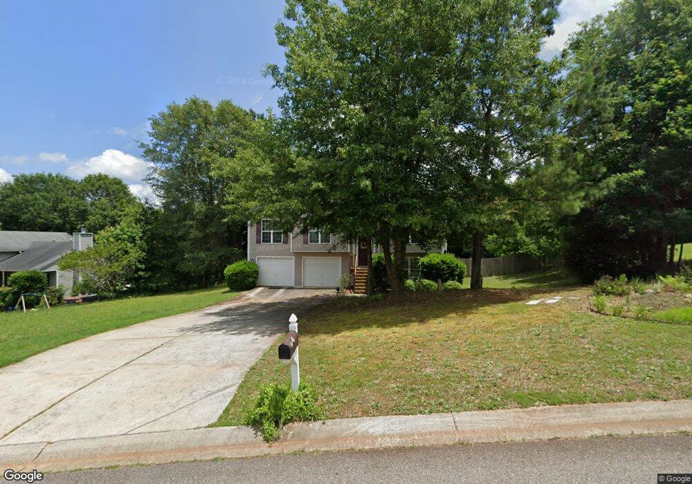
1411 Blanding Way Winder, GA 30680
Estimated Value: $302,468 - $322,000
3
Beds
2
Baths
1,568
Sq Ft
$200/Sq Ft
Est. Value
About This Home
This home is located at 1411 Blanding Way, Winder, GA 30680 and is currently estimated at $314,117, approximately $200 per square foot. 1411 Blanding Way is a home located in Barrow County with nearby schools including Statham Elementary School, Bear Creek Middle School, and Winder-Barrow High School.
Ownership History
Date
Name
Owned For
Owner Type
Purchase Details
Closed on
Apr 11, 2007
Sold by
Southfork Hms Inc
Bought by
Fugiel Carrie L and Fugiel Christopher R
Current Estimated Value
Home Financials for this Owner
Home Financials are based on the most recent Mortgage that was taken out on this home.
Original Mortgage
$148,400
Outstanding Balance
$89,727
Interest Rate
6.15%
Mortgage Type
New Conventional
Estimated Equity
$224,390
Purchase Details
Closed on
Sep 27, 2006
Sold by
Hkb Inc
Bought by
Southfork Homes Inc
Purchase Details
Closed on
Jul 25, 2002
Bought by
Hkb Inc
Create a Home Valuation Report for This Property
The Home Valuation Report is an in-depth analysis detailing your home's value as well as a comparison with similar homes in the area
Home Values in the Area
Average Home Value in this Area
Purchase History
| Date | Buyer | Sale Price | Title Company |
|---|---|---|---|
| Fugiel Carrie L | $148,400 | -- | |
| Southfork Homes Inc | $35,000 | -- | |
| Hkb Inc | -- | -- |
Source: Public Records
Mortgage History
| Date | Status | Borrower | Loan Amount |
|---|---|---|---|
| Open | Fugiel Carrie L | $148,400 |
Source: Public Records
Tax History Compared to Growth
Tax History
| Year | Tax Paid | Tax Assessment Tax Assessment Total Assessment is a certain percentage of the fair market value that is determined by local assessors to be the total taxable value of land and additions on the property. | Land | Improvement |
|---|---|---|---|---|
| 2024 | $2,332 | $102,631 | $26,800 | $75,831 |
| 2023 | $1,773 | $95,138 | $25,200 | $69,938 |
| 2022 | $2,124 | $78,878 | $18,000 | $60,878 |
| 2021 | $2,072 | $72,462 | $18,000 | $54,462 |
| 2020 | $1,903 | $65,586 | $16,000 | $49,586 |
| 2019 | $1,932 | $65,586 | $16,000 | $49,586 |
| 2018 | $1,760 | $59,308 | $14,000 | $45,308 |
| 2017 | $1,381 | $47,415 | $14,000 | $33,415 |
| 2016 | $1,313 | $44,440 | $14,000 | $30,440 |
| 2015 | $1,328 | $44,766 | $14,000 | $30,766 |
| 2014 | $1,129 | $37,953 | $6,860 | $31,093 |
| 2013 | -- | $39,650 | $6,860 | $32,790 |
Source: Public Records
Map
Nearby Homes
- 113 Platte St
- 207 Cedar Grove Church Rd
- 670 Cedar Grove Church Rd
- 670 Cedar Grove Church Rd
- 1724 Cedar Grove Church Rd
- 3845 S Highway 82
- 1453 Solomon Dr
- 1431 Solomon Dr
- 144 Briar Rose Blvd
- 1023 Solomon Ct
- 385 Finch Landing Rd
- 212 Rainbow Ln
- 1415 Red Oak Way
- 1914 Hearthstone Ct
- 51 Brockton Way Unit 2
- 1642 White Oak Dr
- 0 Berch Tree Trail Unit LOT 12
- 0 Berch Tree Trail Unit LOT 7
- 0 Berch Tree Trail Unit 7665580
- 0 Berch Tree Trail Unit 7665573
- 1409 Blanding Way
- 1413 Blanding Way
- 1413 Blanding Way Unit 1
- 204 Stream Unit Ct
- 1410 Blanding Way
- 1407 Blanding Way
- 208 Stream Side Ct Unit Ct
- 208 Stream Side Ct
- 204 Stream Side Ct
- 1415 Blanding Way (Lot50b)
- 1415 Blanding Way
- 1620 Bismarck Cir
- 210 Stream Side Ct Unit Ct
- 210 Stream Side Ct
- 1614 Bismarck Cir
- 109 Platte St
- 1616 Bismarck Cir
- 202 Stream Side Ct
- 105 Platte St
- 111 Platte St