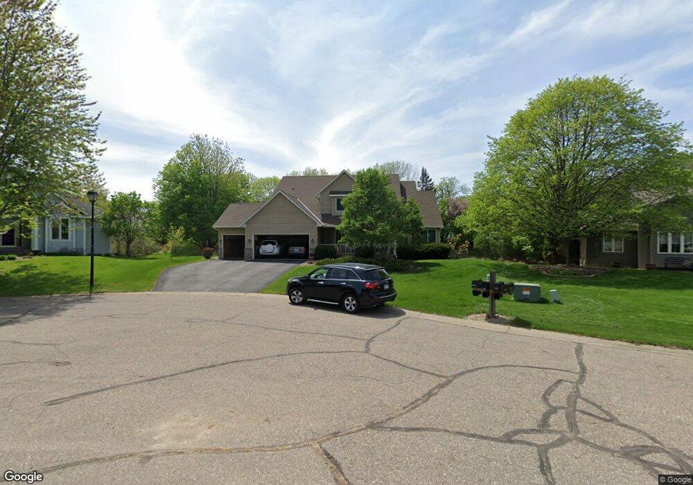
14183 Foxtail Ct Saint Paul, MN 55124
Cedar Isle NeighborhoodEstimated Value: $654,000 - $679,000
6
Beds
5
Baths
2,736
Sq Ft
$243/Sq Ft
Est. Value
About This Home
This home is located at 14183 Foxtail Ct, Saint Paul, MN 55124 and is currently estimated at $665,448, approximately $243 per square foot. 14183 Foxtail Ct is a home located in Dakota County with nearby schools including Greenleaf Elementary School, Falcon Ridge Middle School, and Eastview Senior High School.
Ownership History
Date
Name
Owned For
Owner Type
Purchase Details
Closed on
May 3, 1996
Sold by
Developmen Arcon
Bought by
Donald L Johnson Homes Inc
Current Estimated Value
Purchase Details
Closed on
Mar 30, 1996
Sold by
Donald L Johnson Homes Inc
Bought by
Halvorsen Dale and Halvorsen Colleen
Create a Home Valuation Report for This Property
The Home Valuation Report is an in-depth analysis detailing your home's value as well as a comparison with similar homes in the area
Home Values in the Area
Average Home Value in this Area
Purchase History
| Date | Buyer | Sale Price | Title Company |
|---|---|---|---|
| Donald L Johnson Homes Inc | $46,500 | -- | |
| Halvorsen Dale | $220,865 | -- |
Source: Public Records
Mortgage History
| Date | Status | Borrower | Loan Amount |
|---|---|---|---|
| Closed | Donald L Johnson Homes Inc | -- |
Source: Public Records
Tax History Compared to Growth
Tax History
| Year | Tax Paid | Tax Assessment Tax Assessment Total Assessment is a certain percentage of the fair market value that is determined by local assessors to be the total taxable value of land and additions on the property. | Land | Improvement |
|---|---|---|---|---|
| 2024 | $7,254 | $621,000 | $174,200 | $446,800 |
| 2023 | $7,254 | $617,900 | $174,500 | $443,400 |
| 2022 | $5,970 | $589,900 | $174,000 | $415,900 |
| 2021 | $5,934 | $510,700 | $151,200 | $359,500 |
| 2020 | $5,922 | $498,300 | $144,000 | $354,300 |
| 2019 | $5,404 | $482,200 | $137,200 | $345,000 |
| 2018 | $5,429 | $459,100 | $130,600 | $328,500 |
| 2017 | $5,460 | $440,600 | $124,400 | $316,200 |
| 2016 | $5,827 | $419,800 | $118,500 | $301,300 |
| 2015 | $5,550 | $442,600 | $116,200 | $326,400 |
| 2014 | -- | $424,500 | $111,900 | $312,600 |
| 2013 | -- | $385,680 | $102,881 | $282,799 |
Source: Public Records
Map
Nearby Homes
- 14461 Freesia Way
- 14217 Footbridge Way
- 13954 Flagstaff Ct
- 13947 Fleetwood Ave
- 14057 Flintwood Ct
- 7342 Upper 139th St W
- 7291 Upper 136th St W
- 13720 Georgia Dr
- 13868 Glendale Ct
- 14620 Garrett Ave Unit 310
- 7662 142nd St W
- 14242 Glencove Trail
- 13715 Grafton Ct
- 7577 138th St W
- 13358 Foliage Ave
- 13973 Falcon Ave
- 6790 132nd St W
- 13912 Farmington Way
- 6567 133rd St W
- 14080 Guthrie Ave
- 14192 Foxtail Ct
- 14159 Foxtail Ct
- 14221 Flagstone Trail
- 7024 142nd St W
- 14213 Flagstone Trail
- 14168 Foxtail Ct
- 7025 142nd St W
- 14111 Freeport Ct
- 14169 Freeport Trail
- 14205 Flagstone Trail
- 14095 Freeport Ct
- 14175 Freeport Trail
- 7016 Upper 143rd Ct W
- 7036 142nd St W
- 7039 142nd St W
- 14197 Flagstone Trail
- 14181 Freeport Trail
- 14079 Freeport Ct
- 14215 Fridley Way
- 7048 142nd St W