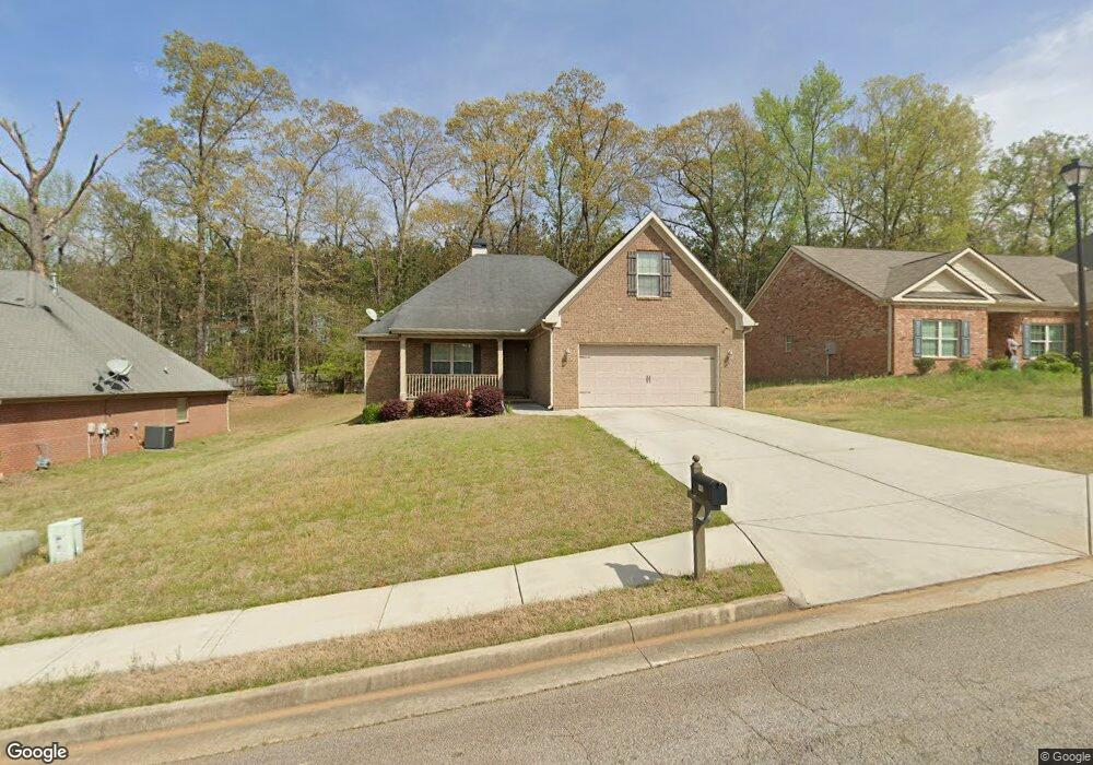
142 Saint Margrit Cir Unit LOT 22 Stockbridge, GA 30281
Estimated Value: $345,883 - $370,000
3
Beds
2
Baths
2,292
Sq Ft
$155/Sq Ft
Est. Value
About This Home
This home is located at 142 Saint Margrit Cir Unit LOT 22, Stockbridge, GA 30281 and is currently estimated at $354,221, approximately $154 per square foot. 142 Saint Margrit Cir Unit LOT 22 is a home located in Henry County with nearby schools including Pate's Creek Elementary School, Dutchtown Middle School, and Dutchtown High School.
Ownership History
Date
Name
Owned For
Owner Type
Purchase Details
Closed on
Mar 6, 2014
Sold by
Mcdonough Parkway Llc
Bought by
Jackson Jo Ann
Current Estimated Value
Home Financials for this Owner
Home Financials are based on the most recent Mortgage that was taken out on this home.
Original Mortgage
$164,900
Outstanding Balance
$124,142
Interest Rate
4.24%
Mortgage Type
New Conventional
Estimated Equity
$230,079
Purchase Details
Closed on
Jun 1, 2012
Sold by
Heritage Bank
Bought by
Mcdonough Parkway Llc
Create a Home Valuation Report for This Property
The Home Valuation Report is an in-depth analysis detailing your home's value as well as a comparison with similar homes in the area
Home Values in the Area
Average Home Value in this Area
Purchase History
| Date | Buyer | Sale Price | Title Company |
|---|---|---|---|
| Jackson Jo Ann | $169,900 | -- | |
| Mcdonough Parkway Llc | $17,000 | -- |
Source: Public Records
Mortgage History
| Date | Status | Borrower | Loan Amount |
|---|---|---|---|
| Open | Jackson Jo Ann | $164,900 |
Source: Public Records
Tax History Compared to Growth
Tax History
| Year | Tax Paid | Tax Assessment Tax Assessment Total Assessment is a certain percentage of the fair market value that is determined by local assessors to be the total taxable value of land and additions on the property. | Land | Improvement |
|---|---|---|---|---|
| 2025 | $3,508 | $144,120 | $16,000 | $128,120 |
| 2024 | $3,508 | $144,920 | $16,000 | $128,920 |
| 2023 | $2,699 | $134,760 | $14,000 | $120,760 |
| 2022 | $4,363 | $107,440 | $14,000 | $93,440 |
| 2021 | $3,700 | $90,040 | $14,000 | $76,040 |
| 2020 | $3,634 | $88,320 | $13,600 | $74,720 |
| 2019 | $3,289 | $81,080 | $10,000 | $71,080 |
| 2018 | $2,953 | $72,320 | $10,000 | $62,320 |
| 2016 | $2,831 | $69,120 | $8,000 | $61,120 |
| 2015 | $2,867 | $67,960 | $7,951 | $60,009 |
| 2014 | $2,738 | $63,920 | $8,000 | $55,920 |
Source: Public Records
Map
Nearby Homes
- 1448 Flippen Rd
- 1468 Flippen Rd
- 139 Surge Stone Ln
- 106 Oakwood Cir
- 257 Turnstone Rd
- 195 Northpark Trail
- 503 Goldfinch Way
- 924 Dexter Dr
- 396 Avian Forest Dr
- 377 Avian Forest Dr
- 198 Broder Farms Dr
- 0 Killearn Blvd Unit 10142611
- 204 N Main Ct
- 537 Goldfinch Way
- 20 Lisa Ct
- 1545 Brangus Dr
- 0 Rock Quarry Rd Unit 10142677
- 1653 Jersey Dr
- 4025 Jamaica Dr
- 1256 Jodeco Rd
- 142 Saint Margrit Cir
- 142 St Margrit Cir
- 140 Saint Margrit Cir Unit 21
- 140 Saint Margrit Cir
- 144 Saint Margrit Cir
- 138 Saint Margrit Cir
- 146 Saint Margrit Cir
- 125 Saint Margrit Cir
- 125 St Margrit Cir Unit 38
- 125 St Margrit Cir
- 125 St Margrit Cir Unit 39
- 127 Saint Margrit Cir
- 123 Saint Margrit Cir Unit 39
- 123 Saint Margrit Cir
- 129 Saint Margrit Cir
- 117 Saint Margrit Cir
- 148 Saint Margrit Cir Unit 25
- 148 Saint Margrit Cir
- 136 Saint Margrit Cir
- 136 Saint Margrit Cir Unit 19