
Seller's Agent in 2025
Stephanie Peck
eXp Realty, LLC
(503) 832-0180
1 in this area
411 Total Sales


Estimated Value: $457,556
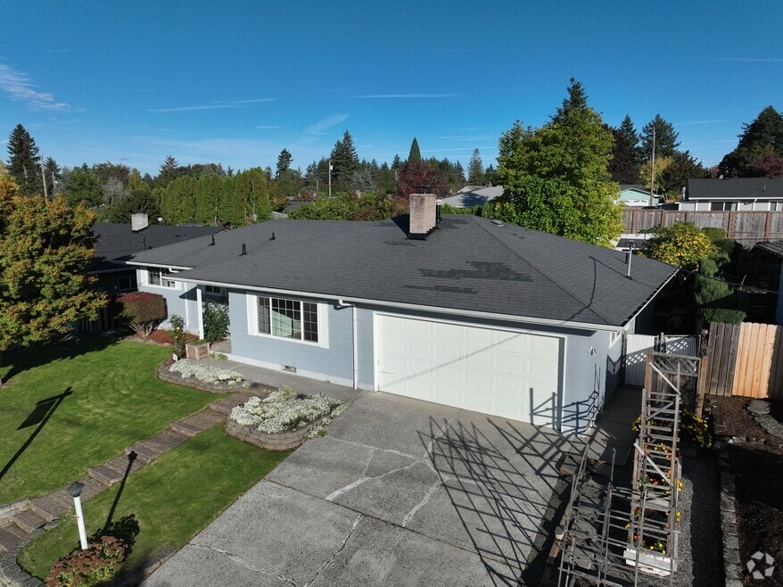
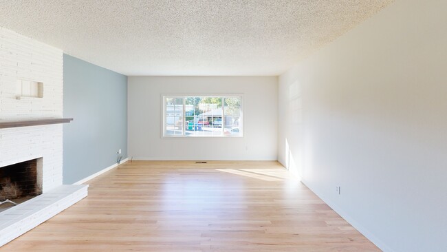
Charming Single-Level Home with Spacious Yard and Timeless Details. Welcome to this beautifully maintained 3-bedroom home offering comfort, charm, and convenience in a quiet, established neighborhood. Step inside to discover refinished hardwood floors and a bright, inviting family room featuring a large picture window and cozy fireplace, perfect for relaxing or entertaining. The updated, spacious kitchen offers generous counter space and storage, ideal for home chefs and family gatherings. Outside, enjoy a huge yard with room to garden, play, or simply unwind among the mature landscaping. A storage shed provides extra space for tools and hobbies, and there’s plenty of parking for guests, RVs, or extra vehicles. Conveniently located near shopping, freeways, and City amenities, this home combines peaceful living with easy access to everything you need.
Last Agent to Sell the Property
eXp Realty, LLC Brokerage Phone: 503-832-0180 License #200708180 Listed on: 10/22/2025
| Date | Buyer | Sale Price | Title Company |
|---|---|---|---|
| Devore Kelsey Lynn | $460,000 | Chicago Title | |
| Kriss Adam R | $159,000 | Chicago Title Insurance Co |
| Date | Status | Borrower | Loan Amount |
|---|---|---|---|
| Open | Devore Kelsey Lynn | $368,000 | |
| Previous Owner | Kriss Adam R | $127,200 | |
| Closed | Kriss Adam R | $31,800 |
| Date | Event | Price | List to Sale | Price per Sq Ft |
|---|---|---|---|---|
| 12/11/2025 12/11/25 | Sold | $460,000 | 0.0% | $324 / Sq Ft |
| 11/13/2025 11/13/25 | Pending | -- | -- | -- |
| 10/22/2025 10/22/25 | For Sale | $460,000 | -- | $324 / Sq Ft |
| Year | Tax Paid | Tax Assessment Tax Assessment Total Assessment is a certain percentage of the fair market value that is determined by local assessors to be the total taxable value of land and additions on the property. | Land | Improvement |
|---|---|---|---|---|
| 2025 | $4,418 | $217,100 | -- | -- |
| 2024 | $4,229 | $210,780 | -- | -- |
| 2023 | $3,853 | $204,650 | $0 | $0 |
| 2022 | $3,745 | $198,690 | $0 | $0 |
| 2021 | $3,651 | $192,910 | $0 | $0 |
| 2020 | $3,435 | $187,300 | $0 | $0 |
| 2019 | $3,346 | $181,850 | $0 | $0 |
| 2018 | $3,190 | $176,560 | $0 | $0 |
| 2017 | $3,061 | $171,420 | $0 | $0 |
| 2016 | $2,699 | $166,430 | $0 | $0 |
| 2015 | $2,640 | $161,590 | $0 | $0 |
| 2014 | $2,576 | $156,890 | $0 | $0 |
Seller's Agent in 2025
Stephanie Peck
eXp Realty, LLC
(503) 832-0180
1 in this area
411 Total Sales
Buyer's Agent in 2025
Amanda Boden
Keller Williams Realty Portland Elite
(503) 744-0000
1 in this area
7 Total Sales
Source: Regional Multiple Listing Service (RMLS)
MLS Number: 128024267
APN: R275313
Disclaimer: Certain information contained herein is derived from information provided by parties other than Homes.com. All information provided is deemed reliable, but is not guaranteed to be accurate and should be independently verified.
![]() The content relating to real estate for sale on this web site comes in part from the IDX program of the RMLS™ of Portland, Oregon. Real estate listings held by brokerage firms other than Ten-X are marked with the RMLS™ logo, and detailed information about these properties includes the names of the listing brokers. Listing content is copyright © 2026 RMLS™, Portland, Oregon. Some properties which appear for sale on this web site may subsequently have sold or may no longer be available. All information provided is deemed reliable but is not guaranteed and should be independently verified.
The content relating to real estate for sale on this web site comes in part from the IDX program of the RMLS™ of Portland, Oregon. Real estate listings held by brokerage firms other than Ten-X are marked with the RMLS™ logo, and detailed information about these properties includes the names of the listing brokers. Listing content is copyright © 2026 RMLS™, Portland, Oregon. Some properties which appear for sale on this web site may subsequently have sold or may no longer be available. All information provided is deemed reliable but is not guaranteed and should be independently verified.
Ask me questions while you tour the home.