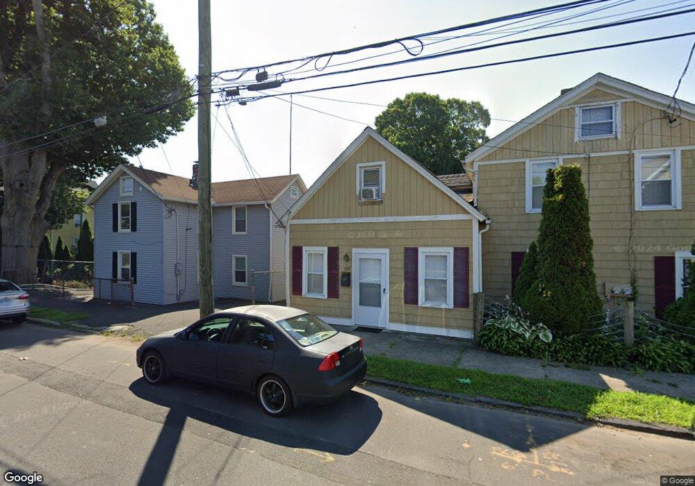
143 Alice St Bridgeport, CT 06606
Brooklawn-Saint Vincent NeighborhoodEstimated Value: $468,000 - $561,000
4
Beds
2
Baths
2,203
Sq Ft
$227/Sq Ft
Est. Value
About This Home
This home is located at 143 Alice St, Bridgeport, CT 06606 and is currently estimated at $500,000, approximately $226 per square foot. 143 Alice St is a home located in Fairfield County with nearby schools including Read School, Central High School, and Catholic Academy of Bridgeport-St. Raphael Academy.
Ownership History
Date
Name
Owned For
Owner Type
Purchase Details
Closed on
Dec 6, 2001
Sold by
Valentino Anthony
Bought by
Azarm Bahman and Azarm Andrea
Current Estimated Value
Purchase Details
Closed on
Jun 17, 1994
Sold by
Bocchino Joseph A
Bought by
Valentino Anthony M
Purchase Details
Closed on
Oct 11, 1989
Sold by
Hafele Laura
Bought by
Bocchino Joseph
Create a Home Valuation Report for This Property
The Home Valuation Report is an in-depth analysis detailing your home's value as well as a comparison with similar homes in the area
Home Values in the Area
Average Home Value in this Area
Purchase History
| Date | Buyer | Sale Price | Title Company |
|---|---|---|---|
| Azarm Bahman | $136,000 | -- | |
| Azarm Bahman | $136,000 | -- | |
| Valentino Anthony M | $85,000 | -- | |
| Valentino Anthony M | $85,000 | -- | |
| Bocchino Joseph | $70,000 | -- |
Source: Public Records
Mortgage History
| Date | Status | Borrower | Loan Amount |
|---|---|---|---|
| Open | Bocchino Joseph | $222,750 | |
| Closed | Bocchino Joseph | $100,000 |
Source: Public Records
Tax History Compared to Growth
Tax History
| Year | Tax Paid | Tax Assessment Tax Assessment Total Assessment is a certain percentage of the fair market value that is determined by local assessors to be the total taxable value of land and additions on the property. | Land | Improvement |
|---|---|---|---|---|
| 2025 | $7,503 | $172,670 | $73,240 | $99,430 |
| 2024 | $7,503 | $172,670 | $73,240 | $99,430 |
| 2023 | $7,503 | $172,670 | $73,240 | $99,430 |
| 2022 | $7,503 | $172,670 | $73,240 | $99,430 |
| 2021 | $7,503 | $172,670 | $73,240 | $99,430 |
| 2020 | $6,950 | $128,720 | $44,370 | $84,350 |
| 2019 | $6,950 | $128,720 | $44,370 | $84,350 |
| 2018 | $6,999 | $128,720 | $44,370 | $84,350 |
| 2017 | $6,999 | $128,720 | $44,370 | $84,350 |
| 2016 | $6,999 | $128,720 | $44,370 | $84,350 |
| 2015 | $6,714 | $159,100 | $44,740 | $114,360 |
| 2014 | $6,714 | $159,100 | $44,740 | $114,360 |
Source: Public Records
Map
Nearby Homes
- 78 Fairmount Ave
- 90 Tom Thumb St
- 390 Charles St Unit 106
- 31 Taft Ave
- 76 Porter St
- 2395 Main St Unit 2397
- 724 Capitol Ave Unit 726
- 119 Madison Terrace
- 191 Oak St
- 318 Center St
- 330 French St
- 356 Taft Ave
- 100 Lorraine St
- 508 Hawley Ave
- 201 High Ridge Dr
- 183 Calhoun Ave
- 1275 Capitol Ave
- 2345 Park Ave
- 139 Highland Ave Unit 143
- 106 Manhattan Ave Unit 108
- 133 Alice St
- 97 Alice St Unit 101
- 161 Alice St
- 140 Alice St Unit S2
- 140 Alice St Unit 303
- 168 Alice St
- 158 Alice St
- 113 Alice St
- 167 Alice St
- 106 Alice St
- 106 Alice St Unit 2
- 107 Alice St
- 126 Beers St
- 96 Beers St
- 176 Alice St
- 176 Alice St Unit 1
- 118 Beers St Unit 120
- 114 Beers St Unit 116
- 225 Wheeler Ave
- 183 Alice St