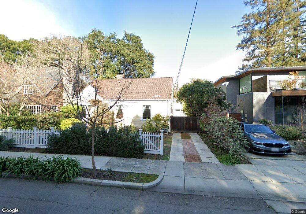
1437 Byron St Palo Alto, CA 94301
University South NeighborhoodEstimated Value: $3,110,000 - $3,942,000
3
Beds
2
Baths
1,152
Sq Ft
$3,012/Sq Ft
Est. Value
About This Home
This home is located at 1437 Byron St, Palo Alto, CA 94301 and is currently estimated at $3,469,749, approximately $3,011 per square foot. 1437 Byron St is a home located in Santa Clara County with nearby schools including Walter Hays Elementary, Frank S. Greene Jr. Middle, and Palo Alto High School.
Ownership History
Date
Name
Owned For
Owner Type
Purchase Details
Closed on
Sep 2, 2021
Sold by
Richter Hans S and Richter Maria Cristina
Bought by
Richter Hans S and Richter Maria Cristina
Current Estimated Value
Purchase Details
Closed on
Feb 26, 1998
Sold by
Ulvanig Lucia
Bought by
Richter Hans J and Richter Maria Cristina
Home Financials for this Owner
Home Financials are based on the most recent Mortgage that was taken out on this home.
Original Mortgage
$450,000
Outstanding Balance
$81,451
Interest Rate
6.9%
Estimated Equity
$3,388,298
Create a Home Valuation Report for This Property
The Home Valuation Report is an in-depth analysis detailing your home's value as well as a comparison with similar homes in the area
Home Values in the Area
Average Home Value in this Area
Purchase History
| Date | Buyer | Sale Price | Title Company |
|---|---|---|---|
| Richter Hans S | -- | None Available | |
| Richter Hans J | $595,000 | Chicago Title Co |
Source: Public Records
Mortgage History
| Date | Status | Borrower | Loan Amount |
|---|---|---|---|
| Open | Richter Hans J | $450,000 |
Source: Public Records
Tax History Compared to Growth
Tax History
| Year | Tax Paid | Tax Assessment Tax Assessment Total Assessment is a certain percentage of the fair market value that is determined by local assessors to be the total taxable value of land and additions on the property. | Land | Improvement |
|---|---|---|---|---|
| 2025 | $13,361 | $1,079,137 | $798,377 | $280,760 |
| 2024 | $13,361 | $1,057,978 | $782,723 | $275,255 |
| 2023 | $13,160 | $1,037,234 | $767,376 | $269,858 |
| 2022 | $13,001 | $1,016,897 | $752,330 | $264,567 |
| 2021 | $12,742 | $996,959 | $737,579 | $259,380 |
| 2020 | $12,489 | $986,738 | $730,017 | $256,721 |
| 2019 | $12,347 | $967,391 | $715,703 | $251,688 |
| 2018 | $12,019 | $948,423 | $701,670 | $246,753 |
| 2017 | $11,806 | $929,827 | $687,912 | $241,915 |
| 2016 | $11,492 | $911,596 | $674,424 | $237,172 |
| 2015 | $11,374 | $897,904 | $664,294 | $233,610 |
| 2014 | $11,084 | $880,316 | $651,282 | $229,034 |
Source: Public Records
Map
Nearby Homes
- 1119 Hopkins Ave
- 1218 Middlefield Rd
- 671 Kingsley Ave
- 1730 Webster St
- 535 Kingsley Ave
- 1711 Guinda St
- 627 Tennyson Ave
- 1409 Parkinson Ave
- 1033 Guinda St
- 560 Addison Ave
- 444 Tennyson Ave
- 265 Coleridge Ave
- 1027 Waverley St
- 231 Churchill Ave
- 961 Channing Ave
- 20 Kent Place
- 326 Addison Ave
- 637 Channing Ave
- 1331 Alma St
- 148 Kingsley Ave
- 1427 Byron St
- 1447 Byron St
- 1419 Byron St
- 1440 Middlefield Rd
- 1450 Middlefield Rd
- 1430 Middlefield Rd
- 1485 Byron St
- 1415 Byron St
- 1460 Middlefield Rd
- 1420 Middlefield Rd
- 1480 Middlefield Rd
- 1410 Middlefield Rd
- 1480 Byron St
- 1420 Byron St
- 1431 Webster St
- 666 Kellogg Ave
- 1505 Byron St
- 1500 Middlefield Rd
- 686 Kellogg Ave
- 1504 Byron St