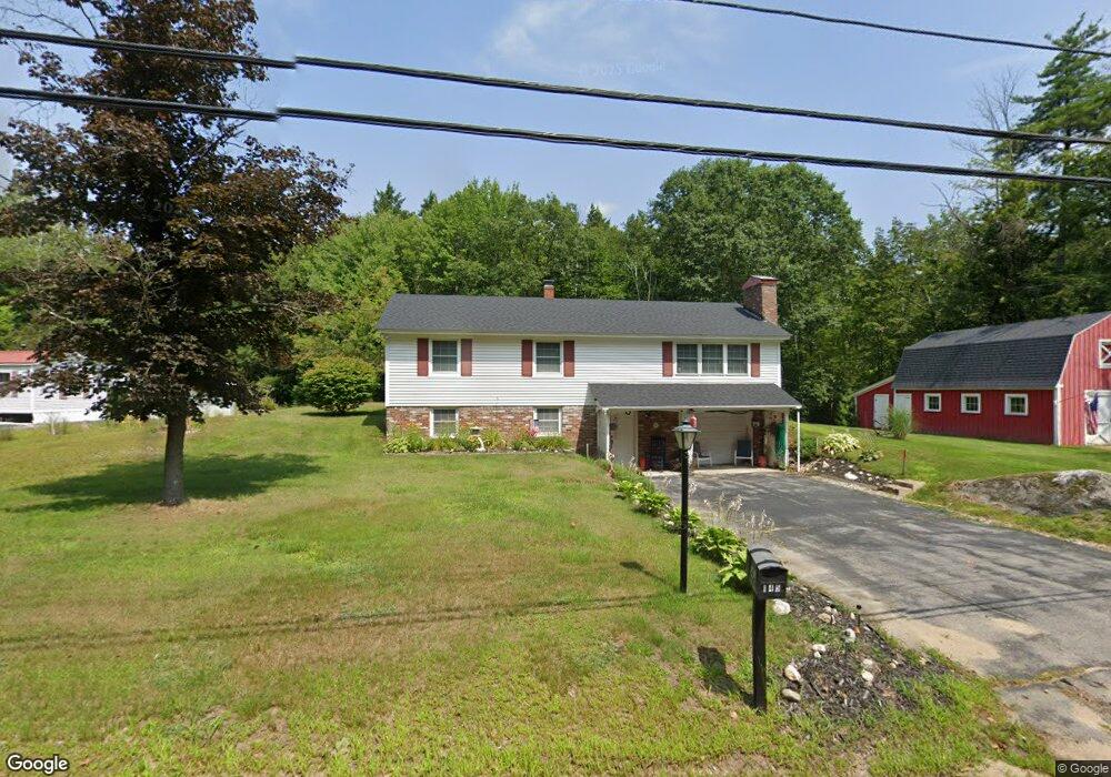
145 Stark Rd Center Conway, NH 03813
Estimated Value: $406,463 - $429,000
3
Beds
1
Bath
1,616
Sq Ft
$258/Sq Ft
Est. Value
About This Home
This home is located at 145 Stark Rd, Center Conway, NH 03813 and is currently estimated at $417,366, approximately $258 per square foot. 145 Stark Rd is a home located in Carroll County with nearby schools including A. Crosby Kennett Middle School, Kennett High School, and Robert Frost Charter School.
Create a Home Valuation Report for This Property
The Home Valuation Report is an in-depth analysis detailing your home's value as well as a comparison with similar homes in the area
Home Values in the Area
Average Home Value in this Area
Tax History Compared to Growth
Tax History
| Year | Tax Paid | Tax Assessment Tax Assessment Total Assessment is a certain percentage of the fair market value that is determined by local assessors to be the total taxable value of land and additions on the property. | Land | Improvement |
|---|---|---|---|---|
| 2024 | $4,594 | $379,700 | $120,000 | $259,700 |
| 2023 | $4,143 | $379,700 | $120,000 | $259,700 |
| 2022 | $3,095 | $171,400 | $60,000 | $111,400 |
| 2021 | $2,801 | $171,400 | $60,000 | $111,400 |
| 2020 | $2,972 | $171,400 | $60,000 | $111,400 |
| 2019 | $2,969 | $171,400 | $60,000 | $111,400 |
| 2018 | $1,444 | $145,700 | $55,000 | $90,700 |
| 2017 | $2,911 | $145,700 | $55,000 | $90,700 |
| 2016 | $2,813 | $145,700 | $55,000 | $90,700 |
| 2015 | $2,781 | $145,700 | $55,000 | $90,700 |
| 2014 | $2,748 | $145,700 | $55,000 | $90,700 |
| 2013 | $2,658 | $148,800 | $55,000 | $93,800 |
Source: Public Records
Map
Nearby Homes
- 66 Woodland Grove
- 18 Woodland Grove Rd
- 101 Odell Hill Rd
- 258 Odell Hill Rd
- 00 Tamarack Overlook
- 357 Lamplighters Park
- 196 E Main St Unit 5 (old 103)
- 33 Longbow Dr
- 19 Saco St Unit 92
- 19 Saco St Unit 59
- 19 Saco St Unit 58
- 42 Buckingham Dr
- 41 Castle Dr
- 9 E Side Rd
- 26 Campfire St
- 60 Lamplighters Park
- 00 Stritch Rd Unit 58
- 58 Wilder St
- 48 Maple Manor Rd
- 357 Lamplighters Dr
- 127 Stark Rd
- 127 Stark Rd
- 152 Stark Rd
- 159 Stark Rd
- 124 Stark Rd
- 111 Stark Rd
- 170 Stark Rd
- 169 Woodland Grove
- 23 Beechwood Dr
- Lot 41 Stark Rd
- 159 Woodland Grove
- 151 Woodland Grove
- 0 Beechwood Drive C#5
- 73 Woodland Grove
- 320 Stark Rd
- 138 Woodland Grove
- 200 Woodland Grove
- 94 Stark Rd
- 27 Beechwood Dr
- 188 Woodland Grove