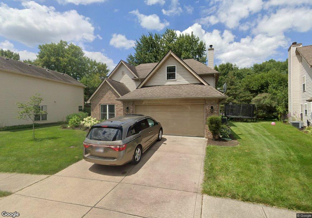
1450 Auburn Dr Brownsburg, IN 46112
Estimated Value: $333,000 - $399,000
4
Beds
3
Baths
2,066
Sq Ft
$172/Sq Ft
Est. Value
About This Home
This home is located at 1450 Auburn Dr, Brownsburg, IN 46112 and is currently estimated at $356,059, approximately $172 per square foot. 1450 Auburn Dr is a home located in Hendricks County with nearby schools including Lincoln Elementary, Brownsburg East Middle School, and Brownsburg High School.
Ownership History
Date
Name
Owned For
Owner Type
Purchase Details
Closed on
Aug 6, 2016
Sold by
Hinders Megan and Hinders Marlin
Bought by
Hinders Neil and Hinders Megan
Current Estimated Value
Home Financials for this Owner
Home Financials are based on the most recent Mortgage that was taken out on this home.
Original Mortgage
$131,054
Outstanding Balance
$102,458
Interest Rate
2.87%
Mortgage Type
FHA
Estimated Equity
$253,601
Purchase Details
Closed on
Jun 19, 2014
Sold by
Pike Holly R
Bought by
Hinders Megan and Hinders Pamela
Home Financials for this Owner
Home Financials are based on the most recent Mortgage that was taken out on this home.
Original Mortgage
$126,170
Interest Rate
3.75%
Mortgage Type
FHA
Purchase Details
Closed on
Jul 31, 2009
Sold by
Gordon Tamara S
Bought by
Pike Holly R
Home Financials for this Owner
Home Financials are based on the most recent Mortgage that was taken out on this home.
Original Mortgage
$135,500
Interest Rate
5.49%
Mortgage Type
FHA
Create a Home Valuation Report for This Property
The Home Valuation Report is an in-depth analysis detailing your home's value as well as a comparison with similar homes in the area
Home Values in the Area
Average Home Value in this Area
Purchase History
| Date | Buyer | Sale Price | Title Company |
|---|---|---|---|
| Hinders Neil | -- | -- | |
| Hinders Megan | -- | -- | |
| Pike Holly R | -- | None Available |
Source: Public Records
Mortgage History
| Date | Status | Borrower | Loan Amount |
|---|---|---|---|
| Open | Hinders Neil | $131,054 | |
| Closed | Hinders Megan | $126,170 | |
| Previous Owner | Pike Holly R | $135,500 |
Source: Public Records
Tax History Compared to Growth
Tax History
| Year | Tax Paid | Tax Assessment Tax Assessment Total Assessment is a certain percentage of the fair market value that is determined by local assessors to be the total taxable value of land and additions on the property. | Land | Improvement |
|---|---|---|---|---|
| 2024 | $2,918 | $291,800 | $49,900 | $241,900 |
| 2023 | $2,736 | $273,600 | $45,800 | $227,800 |
| 2022 | $2,420 | $242,000 | $42,400 | $199,600 |
| 2021 | $2,036 | $203,600 | $38,600 | $165,000 |
| 2020 | $1,932 | $193,200 | $38,600 | $154,600 |
| 2019 | $1,757 | $175,700 | $36,700 | $139,000 |
| 2018 | $1,679 | $167,900 | $36,700 | $131,200 |
| 2017 | $1,563 | $156,300 | $34,000 | $122,300 |
| 2016 | $1,534 | $153,400 | $34,000 | $119,400 |
| 2014 | $1,404 | $140,400 | $31,200 | $109,200 |
| 2013 | $1,351 | $135,100 | $31,200 | $103,900 |
Source: Public Records
Map
Nearby Homes
- 1505 Arbor Springs Dr
- 725 Hawthorne Ln
- 1415 Beaumont Cir
- 1208 Brittany Cir Unit A
- 1208 Whittington Dr
- 1202 Whittington Dr
- 203 Woodside Ct
- 7215 Barrett Dr
- 7242 Barrett Dr
- 7252 Barrett Dr
- 7250 N State Road 267
- 7695 Burns Dr
- 1284 Summer Ridge Ln
- 7089 Symphony Dr
- 1280 Summer Ridge Ln
- 7166 Rhapsody Way
- 1327 Blue Ridge Ln
- Wexford Plan at Forest Hill
- Promenade Farmhouse Plan at Centennial at Brownsburg - Centennial of Brownsburg
- Promenade Craftsman Plan at Centennial at Brownsburg - Centennial of Brownsburg
- 1442 Auburn Dr
- 1458 Auburn Dr
- 1434 Auburn Dr
- 7741 E County Road 700 N
- 7795 E County Road 700 N
- 7795 E County Road 700 N Unit 2
- 1426 Auburn Dr
- 1474 Auburn Dr
- 706 Woodcote Ln
- 705 Cabot Cir
- 1418 Auburn Dr
- 712 Woodcote Ln
- 703 Woodcote Ln
- 1410 Auburn Dr
- 711 Cabot Cir
- 7745 E County Road 700 N
- 718 Woodcote Ln
- 709 Woodcote Ln
- 717 Cabot Cir