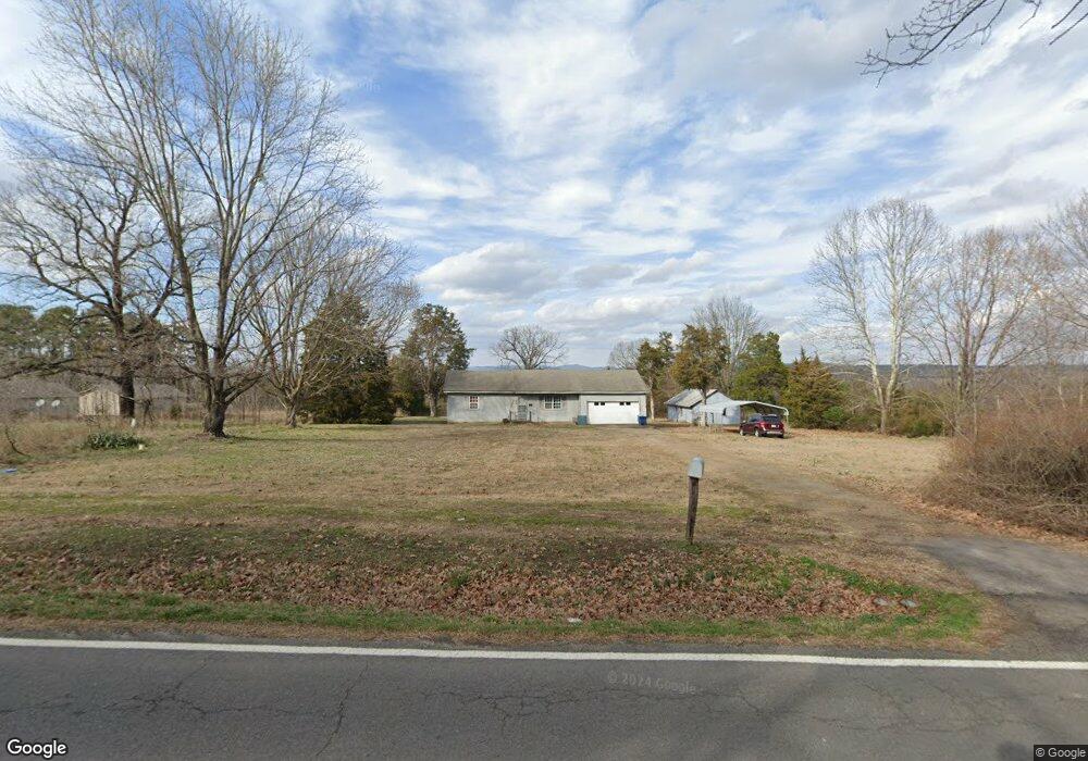
1467 Highway 123 Clarksville, AR 72830
Estimated Value: $131,000 - $165,088
--
Bed
2
Baths
1,280
Sq Ft
$112/Sq Ft
Est. Value
About This Home
This home is located at 1467 Highway 123, Clarksville, AR 72830 and is currently estimated at $142,772, approximately $111 per square foot. 1467 Highway 123 is a home located in Johnson County with nearby schools including Lamar Elementary School, Lamar Middle School, and Lamar High School.
Ownership History
Date
Name
Owned For
Owner Type
Purchase Details
Closed on
Oct 21, 2024
Sold by
Commissioner Of State Lands
Bought by
Rice John Patrick and Rice April Shannon
Current Estimated Value
Home Financials for this Owner
Home Financials are based on the most recent Mortgage that was taken out on this home.
Original Mortgage
$99,674
Outstanding Balance
$71,201
Interest Rate
6.35%
Mortgage Type
New Conventional
Estimated Equity
$71,571
Purchase Details
Closed on
Oct 11, 2024
Sold by
Boen Margaret Shirley and Boen Randall D
Bought by
Rice John Patrick and Rice April Shannon
Home Financials for this Owner
Home Financials are based on the most recent Mortgage that was taken out on this home.
Original Mortgage
$99,674
Outstanding Balance
$71,201
Interest Rate
6.35%
Mortgage Type
New Conventional
Estimated Equity
$71,571
Purchase Details
Closed on
Feb 1, 1994
Bought by
Boen James H
Create a Home Valuation Report for This Property
The Home Valuation Report is an in-depth analysis detailing your home's value as well as a comparison with similar homes in the area
Home Values in the Area
Average Home Value in this Area
Purchase History
| Date | Buyer | Sale Price | Title Company |
|---|---|---|---|
| Rice John Patrick | $817 | None Listed On Document | |
| Rice John Patrick | $122,500 | Currans Abstract & Title | |
| Boen James H | $5,000 | -- |
Source: Public Records
Mortgage History
| Date | Status | Borrower | Loan Amount |
|---|---|---|---|
| Open | Rice John Patrick | $99,674 |
Source: Public Records
Tax History Compared to Growth
Tax History
| Year | Tax Paid | Tax Assessment Tax Assessment Total Assessment is a certain percentage of the fair market value that is determined by local assessors to be the total taxable value of land and additions on the property. | Land | Improvement |
|---|---|---|---|---|
| 2024 | $220 | $19,160 | $2,600 | $16,560 |
| 2023 | $295 | $19,160 | $2,600 | $16,560 |
| 2022 | $345 | $19,160 | $2,600 | $16,560 |
| 2021 | $345 | $19,160 | $2,600 | $16,560 |
| 2020 | $680 | $19,160 | $2,600 | $16,560 |
| 2019 | $345 | $18,300 | $3,300 | $15,000 |
| 2018 | $370 | $18,300 | $3,300 | $15,000 |
| 2017 | $617 | $18,300 | $3,300 | $15,000 |
| 2015 | $267 | $13,530 | $3,300 | $10,230 |
| 2014 | $604 | $13,530 | $2,000 | $11,530 |
| 2013 | $604 | $17,380 | $2,000 | $15,380 |
Source: Public Records
Map
Nearby Homes
- 2767 E Main St
- 1368 E Main St
- 000 Palmer Rd
- 1237 E Main St
- 2968 Arkansas 21
- 954 Harris Rd
- 945 Harris Rd
- 100 S Meadow Place
- CR.3538 Meadow Place
- 139 N Circle Dr
- 125 Alma Ln
- LOT 8 Cr 3467
- Lot 23 Cr 3468
- 607 S Carter St
- 0 Vine & Maple Unit 1324614
- 0 Vine & Maple Unit 1324035
- 0 Vine & Maple Unit 1305021
- 911 Tate St
- 506 Oak St
- 300 E Thompson St
- 1467 Arkansas 123
- 1361 Highway 123
- 1299 E Poplar St
- 1785 Highway 123
- 422 Mason Rd
- 1833 Highway 123
- 1867 E Main St
- 2801 W Main St
- 1891 Highway 123
- 1200 E Main St
- 2300 E Main St
- 2800 E Main St
- 2700 E Main St
- 0 000 Brick Plant Rd./ Hwy 123 Unit 20-516
- 1010 W Main Highway 64
- 1609 E Main St
- 1615 E Main St
- 2600 E Main St
- 2504 E Main St