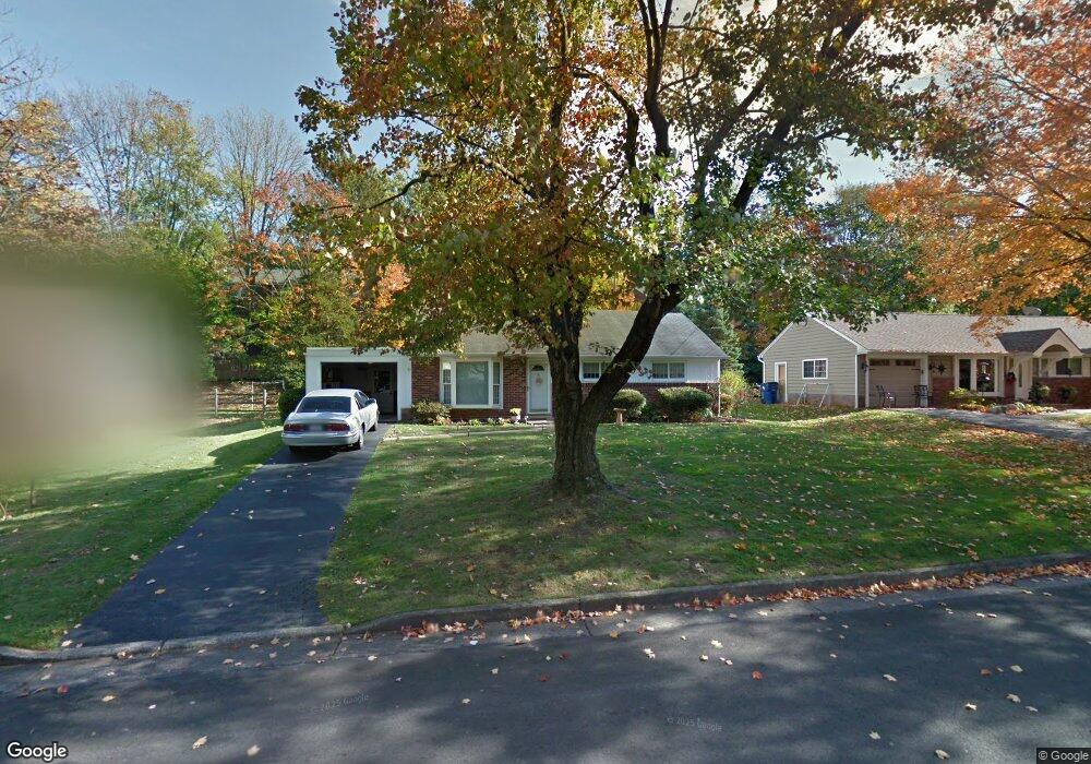
148 Davis Rd Doylestown, PA 18901
Estimated Value: $457,707 - $570,000
3
Beds
1
Bath
1,032
Sq Ft
$485/Sq Ft
Est. Value
About This Home
This home is located at 148 Davis Rd, Doylestown, PA 18901 and is currently estimated at $500,427, approximately $484 per square foot. 148 Davis Rd is a home located in Bucks County with nearby schools including Linden El School, Lenape Middle School, and Central Bucks High School-West.
Ownership History
Date
Name
Owned For
Owner Type
Purchase Details
Closed on
Aug 15, 2019
Sold by
Petko Kathleen J and The Petko Family Trust
Bought by
Cooper John E
Current Estimated Value
Home Financials for this Owner
Home Financials are based on the most recent Mortgage that was taken out on this home.
Original Mortgage
$284,747
Outstanding Balance
$247,664
Interest Rate
3.37%
Mortgage Type
FHA
Estimated Equity
$252,763
Purchase Details
Closed on
Jun 7, 1995
Sold by
Petko John P and Petko Geraldine J
Bought by
Petko John P and Petko Geraldine J
Purchase Details
Closed on
Dec 21, 1992
Bought by
Petko John P and Petko Geraldine J
Create a Home Valuation Report for This Property
The Home Valuation Report is an in-depth analysis detailing your home's value as well as a comparison with similar homes in the area
Home Values in the Area
Average Home Value in this Area
Purchase History
| Date | Buyer | Sale Price | Title Company |
|---|---|---|---|
| Cooper John E | $290,000 | Trident Land Transfer Co Lp | |
| Petko John P | -- | -- | |
| Petko John P | $118,000 | -- |
Source: Public Records
Mortgage History
| Date | Status | Borrower | Loan Amount |
|---|---|---|---|
| Open | Cooper John E | $284,747 |
Source: Public Records
Tax History Compared to Growth
Tax History
| Year | Tax Paid | Tax Assessment Tax Assessment Total Assessment is a certain percentage of the fair market value that is determined by local assessors to be the total taxable value of land and additions on the property. | Land | Improvement |
|---|---|---|---|---|
| 2025 | $3,387 | $18,800 | $6,000 | $12,800 |
| 2024 | $3,387 | $18,800 | $6,000 | $12,800 |
| 2023 | $3,227 | $18,800 | $6,000 | $12,800 |
| 2022 | $3,182 | $18,800 | $6,000 | $12,800 |
| 2021 | $3,147 | $18,800 | $6,000 | $12,800 |
| 2020 | $3,112 | $18,800 | $6,000 | $12,800 |
| 2019 | $3,078 | $18,800 | $6,000 | $12,800 |
| 2018 | $3,040 | $18,800 | $6,000 | $12,800 |
| 2017 | $3,008 | $18,800 | $6,000 | $12,800 |
| 2016 | $3,008 | $18,800 | $6,000 | $12,800 |
| 2015 | -- | $18,800 | $6,000 | $12,800 |
| 2014 | -- | $18,800 | $6,000 | $12,800 |
Source: Public Records
Map
Nearby Homes
- 418 North St
- 121 Cottage St
- 90 Chapman Ave
- 146 N Church St
- 146 E Court St
- 169 N Main St
- 4 Barnes Ct
- 155 E Oakland Ave
- 5 Belmont Square
- 20 E Court St
- 339 E Ashland St
- 69 E Oakland Ave
- 110 E Ashland St
- 104 Kreutz Ave
- 37 N Clinton St
- 333 Dorset Ct Unit 333
- 215 N Franklin St
- 0 Myers Dr
- 143 Myers Dr
- 236 Green St
- 130 Davis Rd
- 184 Davis Rd
- 112 Davis Rd
- 333 Lacey Ave Unit C4
- 333 Lacey Ave Unit D10
- 333 Lacey Ave Unit D9
- 333 Lacey Ave
- 333 Lacey Ave Unit C5
- 333 Lacey Ave
- 333 Lacey Ave
- 333 Lacey Ave Unit A6
- 333 Lacey Ave Unit D12
- 333 Lacey Ave Unit D11
- 333 Lacey Ave Unit 12
- 333 Lacey Ave Unit A11
- 333 Lacey Ave Unit A10
- 333 Lacey Ave Unit D7
- 333 Lacey Ave Unit D6
- 333 Lacey Ave Unit D4
- 333 Lacey Ave Unit D3