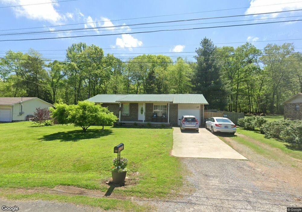
148 Gail Ln Jasper, TN 37347
Estimated Value: $132,000 - $230,085
3
Beds
2
Baths
1,136
Sq Ft
$178/Sq Ft
Est. Value
About This Home
This home is located at 148 Gail Ln, Jasper, TN 37347 and is currently estimated at $202,021, approximately $177 per square foot. 148 Gail Ln is a home located in Marion County with nearby schools including Jasper Elementary School, South Pittsburg Elementary School, and Monteagle Elementary School.
Ownership History
Date
Name
Owned For
Owner Type
Purchase Details
Closed on
Mar 7, 2024
Sold by
Fenn Leslie and Smith Danielle
Bought by
Pilgrim Chastity D
Current Estimated Value
Home Financials for this Owner
Home Financials are based on the most recent Mortgage that was taken out on this home.
Original Mortgage
$93,455
Outstanding Balance
$68,613
Interest Rate
6.69%
Mortgage Type
New Conventional
Estimated Equity
$133,408
Purchase Details
Closed on
Jul 2, 2021
Sold by
Smith Brandi and Smith Laura
Bought by
Pilgrim Chastity D
Purchase Details
Closed on
Sep 11, 2013
Sold by
Chisholm Craig S
Bought by
Gentry Donna Louise
Purchase Details
Closed on
Mar 29, 2013
Bought by
Walker County Gail Trust
Purchase Details
Closed on
Dec 4, 2009
Sold by
Chisholm 148 Gail
Bought by
Walker County Gail
Purchase Details
Closed on
Aug 3, 1995
Bought by
Chisholm Craig S
Create a Home Valuation Report for This Property
The Home Valuation Report is an in-depth analysis detailing your home's value as well as a comparison with similar homes in the area
Home Values in the Area
Average Home Value in this Area
Purchase History
| Date | Buyer | Sale Price | Title Company |
|---|---|---|---|
| Pilgrim Chastity D | $25,000 | None Listed On Document | |
| Pilgrim Chastity D | -- | None Available | |
| Gentry Donna Louise | $63,204 | -- | |
| Walker County Gail Trust | -- | -- | |
| Walker County Gail | -- | -- | |
| Chisholm Craig S | $63,200 | -- |
Source: Public Records
Mortgage History
| Date | Status | Borrower | Loan Amount |
|---|---|---|---|
| Open | Pilgrim Chastity D | $93,455 |
Source: Public Records
Tax History Compared to Growth
Tax History
| Year | Tax Paid | Tax Assessment Tax Assessment Total Assessment is a certain percentage of the fair market value that is determined by local assessors to be the total taxable value of land and additions on the property. | Land | Improvement |
|---|---|---|---|---|
| 2024 | $235 | $32,325 | $4,650 | $27,675 |
| 2023 | $235 | $32,325 | $0 | $0 |
| 2022 | $686 | $32,325 | $4,650 | $27,675 |
| 2021 | $686 | $32,325 | $4,650 | $27,675 |
| 2020 | $647 | $32,325 | $4,650 | $27,675 |
| 2019 | $647 | $25,025 | $3,875 | $21,150 |
| 2018 | $647 | $25,025 | $3,875 | $21,150 |
| 2017 | $647 | $25,025 | $3,875 | $21,150 |
| 2016 | $643 | $25,025 | $0 | $0 |
| 2015 | $656 | $25,025 | $0 | $0 |
| 2014 | $656 | $26,578 | $0 | $0 |
Source: Public Records
Map
Nearby Homes
- 206 Danny Dr
- 712 Kilgore St
- 0 Asher St Unit 1381909
- 3729 Crockett Pointe Unit Jf-145
- 3729 Crockett Pointe
- 3200 Crockett Pointe
- 755 Priest Ave
- 601 Priest Ave
- 1103 Hudson Ave
- 1009 Montrosa Ave
- 813 Mimosa Ave
- 1019 N Dennis Ave
- 415 Marshall Hall Rd
- 1101 Betsy Pack Dr
- 825 Dennis Ave
- 921 Betsy Pack Dr
- 80 High Point Ln
- 179 High Point Ln
- 1899 River Bluffs Dr
- Rb73 River Bluffs Dr