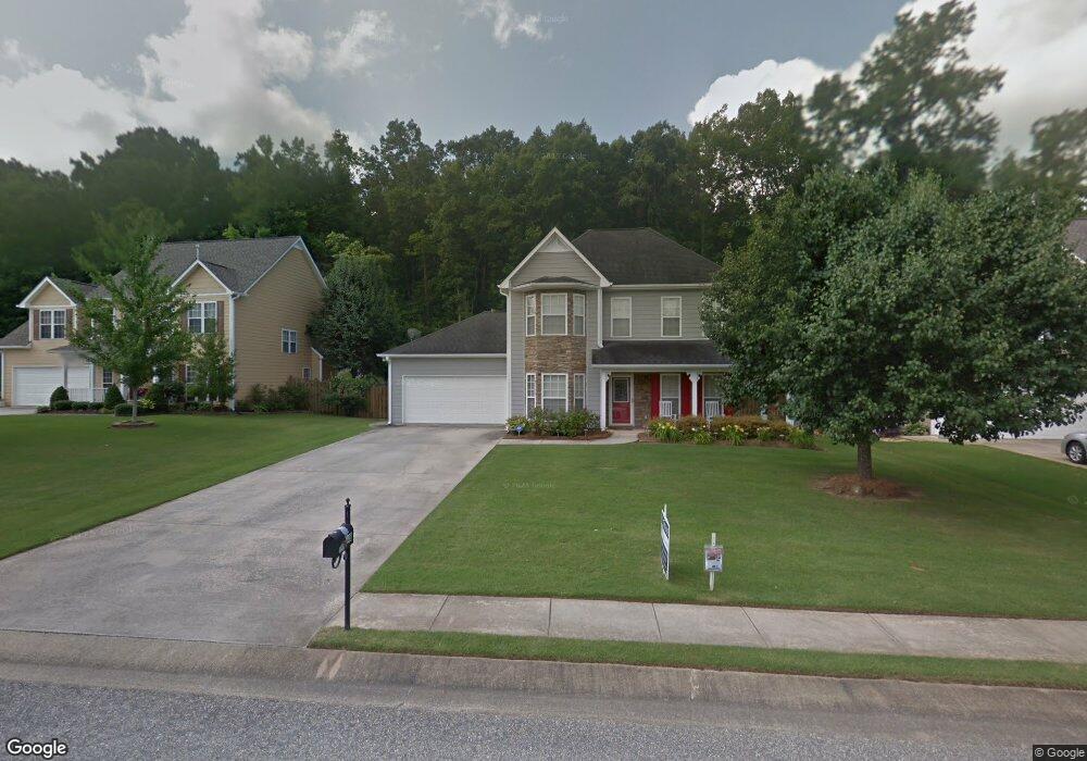
148 Victoria Station Maylene, AL 35114
Estimated Value: $263,000 - $344,000
3
Beds
3
Baths
1,560
Sq Ft
$191/Sq Ft
Est. Value
About This Home
This home is located at 148 Victoria Station, Maylene, AL 35114 and is currently estimated at $298,386, approximately $191 per square foot. 148 Victoria Station is a home located in Shelby County with nearby schools including Thompson Intermediate School, Thompson Middle School, and Thompson High School.
Ownership History
Date
Name
Owned For
Owner Type
Purchase Details
Closed on
Apr 26, 2007
Sold by
Brown Reginald R and Brown Veronica L
Bought by
Scott Kristalyn and Lee Jerome
Current Estimated Value
Home Financials for this Owner
Home Financials are based on the most recent Mortgage that was taken out on this home.
Original Mortgage
$171,000
Outstanding Balance
$103,730
Interest Rate
6.12%
Mortgage Type
Purchase Money Mortgage
Estimated Equity
$194,656
Purchase Details
Closed on
Apr 27, 2001
Sold by
H & T Homebuilders Inc
Bought by
Brown Reginald R and Brown Veronica L
Home Financials for this Owner
Home Financials are based on the most recent Mortgage that was taken out on this home.
Original Mortgage
$140,658
Interest Rate
6.9%
Mortgage Type
VA
Create a Home Valuation Report for This Property
The Home Valuation Report is an in-depth analysis detailing your home's value as well as a comparison with similar homes in the area
Home Values in the Area
Average Home Value in this Area
Purchase History
| Date | Buyer | Sale Price | Title Company |
|---|---|---|---|
| Scott Kristalyn | $171,000 | None Available | |
| Brown Reginald R | -- | -- |
Source: Public Records
Mortgage History
| Date | Status | Borrower | Loan Amount |
|---|---|---|---|
| Open | Scott Kristalyn | $171,000 | |
| Previous Owner | Brown Reginald R | $140,658 |
Source: Public Records
Tax History Compared to Growth
Tax History
| Year | Tax Paid | Tax Assessment Tax Assessment Total Assessment is a certain percentage of the fair market value that is determined by local assessors to be the total taxable value of land and additions on the property. | Land | Improvement |
|---|---|---|---|---|
| 2024 | $1,366 | $25,300 | $0 | $0 |
| 2023 | $1,265 | $24,180 | $0 | $0 |
| 2022 | $1,169 | $22,400 | $0 | $0 |
| 2021 | $1,006 | $19,380 | $0 | $0 |
| 2020 | $926 | $17,900 | $0 | $0 |
| 2019 | $878 | $17,020 | $0 | $0 |
| 2017 | $825 | $16,040 | $0 | $0 |
| 2015 | $781 | $15,220 | $0 | $0 |
| 2014 | $781 | $15,220 | $0 | $0 |
Source: Public Records
Map
Nearby Homes
- 549 Ramsgate Dr
- 236 Queens Gate
- 545 Ramsgate Dr
- 233 Queens Gate
- 309 Cedar Grove Ct
- 306 Mayfair Cir
- 208 Queens Gate
- 501 Ramsgate Dr
- 537 Ramsgate Dr
- 217 Mayfair Park
- 280 Cedar Grove Pkwy
- 109 Kingsley Cir
- 217 Kensington Ln
- 128 Oak St
- 117 Kensington Ln
- 104 Camden Cir
- 1315 Yellowleaf Cir
- 2014 1st Ave W
- 144 Palm Dr
- 1805 Mohawk Dr
- 144 Victoria Station
- 152 Victoria Station
- 140 Victoria Station
- 156 Victoria Station
- 147 Victoria Station
- 141 Victoria Station
- 136 Victoria Station
- 162 Victoria Station
- 159 Victoria Station
- 137 Victoria Station
- 194 Cedar Grove Pkwy
- 190 Cedar Grove Pkwy
- 194 Cedar Grove Pkwy
- 132 Victoria Station
- 196 Cedar Grove Pkwy
- 131 Victoria Station
- 186 Cedar Grove Pkwy
- 202 Cedar Grove Pkwy
- 182 Cedar Grove Pkwy