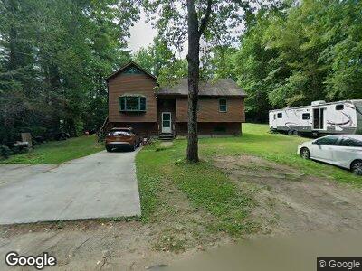
15 Bluefield Rd Ashburnham, MA 01430
Estimated Value: $391,000 - $470,000
3
Beds
2
Baths
1,068
Sq Ft
$401/Sq Ft
Est. Value
About This Home
This home is located at 15 Bluefield Rd, Ashburnham, MA 01430 and is currently estimated at $428,132, approximately $400 per square foot. 15 Bluefield Rd is a home located in Worcester County with nearby schools including Oakmont Regional High School.
Ownership History
Date
Name
Owned For
Owner Type
Purchase Details
Closed on
Jun 15, 2005
Sold by
Apthorp Stephen P and Apthorp Susan C
Bought by
Pickett Karen and Pickett Timothy D
Current Estimated Value
Home Financials for this Owner
Home Financials are based on the most recent Mortgage that was taken out on this home.
Original Mortgage
$170,000
Outstanding Balance
$92,760
Interest Rate
5.78%
Mortgage Type
Purchase Money Mortgage
Estimated Equity
$338,091
Purchase Details
Closed on
Dec 23, 1998
Sold by
Gavin Brian and Gavin Karen A
Bought by
Apthorp Stephen P and Apthrop Susan C
Home Financials for this Owner
Home Financials are based on the most recent Mortgage that was taken out on this home.
Original Mortgage
$90,300
Interest Rate
6.89%
Mortgage Type
Purchase Money Mortgage
Create a Home Valuation Report for This Property
The Home Valuation Report is an in-depth analysis detailing your home's value as well as a comparison with similar homes in the area
Home Values in the Area
Average Home Value in this Area
Purchase History
| Date | Buyer | Sale Price | Title Company |
|---|---|---|---|
| Pickett Karen | $250,000 | -- | |
| Apthorp Stephen P | $129,000 | -- |
Source: Public Records
Mortgage History
| Date | Status | Borrower | Loan Amount |
|---|---|---|---|
| Open | Pickett Karen M | $31,000 | |
| Open | Pickett Karen | $170,000 | |
| Previous Owner | Apthorp Stephen P | $155,000 | |
| Previous Owner | Apthorp Stephen P | $25,000 | |
| Previous Owner | Apthorp Stephen P | $120,000 | |
| Previous Owner | Apthorp Stephen P | $90,300 |
Source: Public Records
Tax History Compared to Growth
Tax History
| Year | Tax Paid | Tax Assessment Tax Assessment Total Assessment is a certain percentage of the fair market value that is determined by local assessors to be the total taxable value of land and additions on the property. | Land | Improvement |
|---|---|---|---|---|
| 2025 | $5,138 | $345,500 | $40,700 | $304,800 |
| 2024 | $5,531 | $351,200 | $40,700 | $310,500 |
| 2023 | $5,109 | $308,700 | $40,700 | $268,000 |
| 2022 | $4,926 | $260,900 | $39,600 | $221,300 |
| 2021 | $10,137 | $221,100 | $39,600 | $181,500 |
| 2020 | $7,250 | $221,100 | $39,600 | $181,500 |
| 2019 | $4,650 | $206,200 | $39,600 | $166,600 |
| 2018 | $4,246 | $194,500 | $37,600 | $156,900 |
| 2017 | $4,034 | $175,600 | $38,400 | $137,200 |
| 2016 | $3,936 | $173,000 | $37,600 | $135,400 |
| 2015 | $3,854 | $173,000 | $37,600 | $135,400 |
Source: Public Records
Map
Nearby Homes
- 12 Spruce Dr
- 0 Bush Hill Rd
- 33 Noel Dr
- 5 W Shore Dr
- 19 Lake View Dr
- 8 Balsam Dr
- 14 Laurel Dr
- 11 Laurel Dr
- 74 Lakeshore Dr
- 11&7&8 Brown's Lake Rd
- 192 Sherbert Rd
- 246 Beachview Dr
- 16 Hilltop Terrace
- 38 Depot Rd
- 345 E Monomonac Rd
- 16 2nd St
- 495 Winchendon Rd
- 483 Winchendon Rd
- Lot 3 W State Rd
- 238 Fourth St