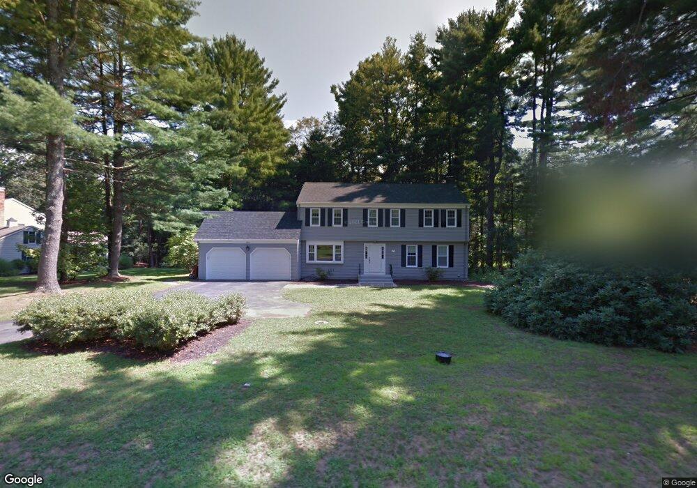
15 Neal Dr Unit 15 Simsbury, CT 06070
Estimated Value: $627,961 - $708,000
4
Beds
3
Baths
2,418
Sq Ft
$277/Sq Ft
Est. Value
About This Home
This home is located at 15 Neal Dr Unit 15, Simsbury, CT 06070 and is currently estimated at $668,740, approximately $276 per square foot. 15 Neal Dr Unit 15 is a home located in Hartford County with nearby schools including Tootin' Hills School, Henry James Memorial School, and Simsbury High School.
Ownership History
Date
Name
Owned For
Owner Type
Purchase Details
Closed on
Sep 16, 2024
Sold by
Curella Patricia A
Bought by
Prior Frank M
Current Estimated Value
Purchase Details
Closed on
Apr 12, 2019
Sold by
Hughes Kevin J and Hughes Rebecca A
Bought by
Curella Patricia A and Prior Frank M
Home Financials for this Owner
Home Financials are based on the most recent Mortgage that was taken out on this home.
Original Mortgage
$360,000
Interest Rate
4.3%
Mortgage Type
Purchase Money Mortgage
Purchase Details
Closed on
Aug 10, 2012
Sold by
Babich Danny and Jordan Ernest
Bought by
Hughes Kevin J and Hughes Rebecca A
Home Financials for this Owner
Home Financials are based on the most recent Mortgage that was taken out on this home.
Original Mortgage
$344,000
Interest Rate
3.7%
Purchase Details
Closed on
Nov 14, 2011
Sold by
Oneil Michael and Rogers Alan
Bought by
Bank Of New York Mello
Purchase Details
Closed on
Sep 12, 2000
Sold by
Hart Candace S
Bought by
Oneil Michael B
Purchase Details
Closed on
Nov 16, 1994
Sold by
Harrell Curtis and Harrell Marva
Bought by
Hart James and Hart Candace
Purchase Details
Closed on
Apr 24, 1989
Sold by
Ingram George
Bought by
Harrell Curtis
Create a Home Valuation Report for This Property
The Home Valuation Report is an in-depth analysis detailing your home's value as well as a comparison with similar homes in the area
Home Values in the Area
Average Home Value in this Area
Purchase History
| Date | Buyer | Sale Price | Title Company |
|---|---|---|---|
| Prior Frank M | -- | None Available | |
| Prior Frank M | -- | None Available | |
| Curella Patricia A | $440,000 | -- | |
| Curella Patricia A | $440,000 | -- | |
| Hughes Kevin J | $430,000 | -- | |
| Bank Of New York Mello | -- | -- | |
| Oneil Michael B | $303,500 | -- | |
| Hart James | $229,900 | -- | |
| Hughes Kevin J | $430,000 | -- | |
| Bank Of New York Mello | -- | -- | |
| Oneil Michael B | $303,500 | -- | |
| Hart James | $229,900 | -- | |
| Harrell Curtis | $272,000 | -- |
Source: Public Records
Mortgage History
| Date | Status | Borrower | Loan Amount |
|---|---|---|---|
| Previous Owner | Curella Patricia A | $360,000 | |
| Previous Owner | Harrell Curtis | $344,000 |
Source: Public Records
Tax History Compared to Growth
Tax History
| Year | Tax Paid | Tax Assessment Tax Assessment Total Assessment is a certain percentage of the fair market value that is determined by local assessors to be the total taxable value of land and additions on the property. | Land | Improvement |
|---|---|---|---|---|
| 2025 | $10,703 | $313,320 | $93,660 | $219,660 |
| 2024 | $10,437 | $313,320 | $93,660 | $219,660 |
| 2023 | $9,970 | $313,320 | $93,660 | $219,660 |
| 2022 | $9,849 | $254,960 | $100,640 | $154,320 |
| 2021 | $9,849 | $254,960 | $100,640 | $154,320 |
| 2020 | $9,456 | $254,960 | $100,640 | $154,320 |
| 2019 | $9,515 | $254,960 | $100,640 | $154,320 |
| 2018 | $9,584 | $254,960 | $100,640 | $154,320 |
| 2017 | $9,001 | $232,230 | $96,310 | $135,920 |
| 2016 | $8,620 | $232,230 | $96,310 | $135,920 |
| 2015 | $8,620 | $232,230 | $96,310 | $135,920 |
| 2014 | $8,625 | $232,230 | $96,310 | $135,920 |
Source: Public Records
Map
Nearby Homes
- 24 Drumlin Rd
- 395 Bushy Hill Rd
- 370A W Mountain Rd
- 14 Nod Brook Dr
- 1 Alcima Dr
- 8 Crane Place
- 25 Tall Wood Hollow
- 120 Climax Rd
- 301 Bushy Hill Rd
- 51 Pine Glen Rd
- 302 Bushy Hill Rd
- 41 Applegate Ln
- 3 Applegate Ln Unit 3
- 31 Applegate Ln Unit 31
- 49 Applegate Ln Unit 49
- 4 Adams Rd
- 41 Secret Lake Rd
- 54 Secret Lake Rd
- 7 Woodmont Rd
- 36 Blue Ridge Dr