
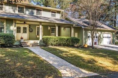
1505 Old John Ward Rd SW Marietta, GA 30064
West Cobb NeighborhoodEstimated payment $6,191/month
Highlights
- Very Popular Property
- Guest House
- Above Ground Pool
- Cheatham Hill Elementary School Rated A
- Second Kitchen
- View of Trees or Woods
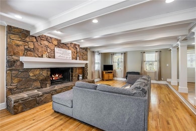
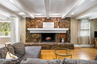
About This Home
Discover an exceptionally private and exclusive opportunity in one of West Cobb’s most desirable locations. Tucked away on a serene 2-acre lot, this unique property features two full homes, ideal for multi-generational living, a guest residence, or investment potential. The main home offers a desirable primary suite on the main level, along with an inviting family room and spacious kitchen. Upstairs, you’ll find two additional bedrooms connected by a classic Jack-and-Jill bathroom, providing both comfort and convenience. Above ground pool and sundeck are located behind the oversized 2 car garage. A large covered party deck on the opposite side of the home connect to both homes! The second home is a true one-level residence with large carport, complete with 2 bedrooms, 1 full and 1 1/2 baths, making it perfect for in-law living, extended guests, or rental income. Thoughtfully designed for accessibility and comfort. With unmatched privacy, Coveted school district, expansive space, and endless possibilities, this rare West Cobb property is an opportunity you won’t find again.
Home Details
Home Type
- Single Family
Est. Annual Taxes
- $1,546
Year Built
- Built in 1974
Lot Details
- 2 Acre Lot
- Landscaped
- Private Lot
- Level Lot
- Wooded Lot
- Garden
- Back Yard Fenced and Front Yard
Parking
- 2 Car Garage
- 2 Carport Spaces
- Driveway
Home Design
- Traditional Architecture
- Slab Foundation
- Frame Construction
- Composition Roof
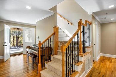
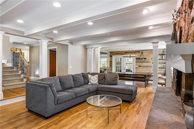
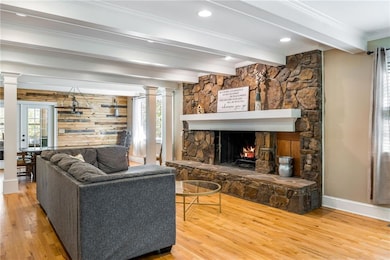
Interior Spaces
- 4,511 Sq Ft Home
- 2-Story Property
- Beamed Ceilings
- Ceiling Fan
- Family Room with Fireplace
- Great Room
- Dining Room Seats More Than Twelve
- Formal Dining Room
- Home Office
- Views of Woods
- Crawl Space
- Laundry Room
Kitchen
- Second Kitchen
- Breakfast Bar
- Double Oven
- Electric Cooktop
- Microwave
- Dishwasher
- Stone Countertops
- Wood Stained Kitchen Cabinets
Flooring
- Wood
- Carpet
- Tile
Bedrooms and Bathrooms
- 5 Bedrooms | 3 Main Level Bedrooms
- Primary Bedroom on Main
- Walk-In Closet
- Dual Vanity Sinks in Primary Bathroom
- Whirlpool Bathtub
- Separate Shower in Primary Bathroom
Outdoor Features
- Above Ground Pool
- Deck
- Patio
- Shed
- Front Porch
Additional Homes
- Guest House
Schools
- Cheatham Hill Elementary School
- Lovinggood Middle School
- Hillgrove High School
Utilities
- Central Heating and Cooling System
- Heating System Uses Natural Gas
- Septic Tank
Community Details
- Homesite Subdivision
Listing and Financial Details
- Assessor Parcel Number 19032600030
Map
Home Values in the Area
Average Home Value in this Area
Tax History
| Year | Tax Paid | Tax Assessment Tax Assessment Total Assessment is a certain percentage of the fair market value that is determined by local assessors to be the total taxable value of land and additions on the property. | Land | Improvement |
|---|---|---|---|---|
| 2025 | $1,546 | $223,712 | $100,000 | $123,712 |
| 2024 | $1,551 | $223,712 | $100,000 | $123,712 |
| 2023 | $1,345 | $223,712 | $100,000 | $123,712 |
| 2022 | $1,503 | $207,712 | $84,000 | $123,712 |
| 2021 | $1,453 | $190,860 | $84,000 | $106,860 |
| 2020 | $1,405 | $174,860 | $68,000 | $106,860 |
| 2019 | $1,405 | $174,860 | $68,000 | $106,860 |
| 2018 | $1,278 | $132,388 | $64,000 | $68,388 |
| 2017 | $1,114 | $132,388 | $64,000 | $68,388 |
| 2016 | $1,091 | $124,388 | $56,000 | $68,388 |
| 2015 | $980 | $100,000 | $42,016 | $57,984 |
| 2014 | $998 | $100,000 | $0 | $0 |
Property History
| Date | Event | Price | List to Sale | Price per Sq Ft |
|---|---|---|---|---|
| 11/14/2025 11/14/25 | For Sale | $1,150,000 | -- | $255 / Sq Ft |
Purchase History
| Date | Type | Sale Price | Title Company |
|---|---|---|---|
| Warranty Deed | -- | -- | |
| Warranty Deed | $250,000 | -- | |
| Deed | $345,000 | -- |
Mortgage History
| Date | Status | Loan Amount | Loan Type |
|---|---|---|---|
| Previous Owner | $276,000 | New Conventional |
Source: First Multiple Listing Service (FMLS)
MLS Number: 7681508
APN: 19-0326-0-003-0
Disclaimer: Certain information contained herein is derived from information provided by parties other than Homes.com. All information provided is deemed reliable, but is not guaranteed to be accurate and should be independently verified.
![]() Listings identified with the FMLS IDX logo come from FMLS and are held by brokerage firms other than the owner of this website. The listing brokerage is identified in any listing details. Information is deemed reliable but is not guaranteed. If you believe any FMLS listing contains material that infringes your copyrighted work please visit www.fmls.com/dmca to review our DMCA policy and learn how to submit a takedown request. © 2025 First Multiple Listing Service, Inc.
Listings identified with the FMLS IDX logo come from FMLS and are held by brokerage firms other than the owner of this website. The listing brokerage is identified in any listing details. Information is deemed reliable but is not guaranteed. If you believe any FMLS listing contains material that infringes your copyrighted work please visit www.fmls.com/dmca to review our DMCA policy and learn how to submit a takedown request. © 2025 First Multiple Listing Service, Inc.
- 1950 Mcadoo Ct SW
- 1400 Mcquiston Ct SW
- 1537 Mcadoo Dr SW
- 2093 Breconridge Dr SW
- 1533 Fallen Leaf Dr SW
- 1646 Desford Ct SW
- 2105 Cornerstone Ln SW
- 994 Gentry Ln SW
- 2040 Hardwood Cir SW Unit 3
- 1265 Channel Park SW
- 1718 Rifle Ridge SW
- 1114 Wind Hill Ln SW
- 2403 Bonshaw Ln
- 1046 Wedgefield Dr SW
- 1126 Wedgefield Dr SW
- 2251 Byron Ct SW
- 2003 Hascall Ridge Ct SW
- 1405 Mcquiston Ct SW
- 1538 Fallen Leaf Dr SW
- 1361 Willowbrook Dr SW
- 2196 Major Loring Way SW
- 2196 Major Loring Way SW Unit ID1234839P
- 1934 Harken Grove
- 1784 Clayhill Pointe SW
- 2020 Clay Dr SW
- 1879 Clay Dr SW
- 1748 Pamela Cir SW
- 1401 Chapel Hill Ln SW
- 1446 Chapel Hill Ln SW
- 2254 Caneridge Trail SW
- 2257 Caneridge Trail SW
- 2206 Arbor Forest Trail SW
- 1898 Winding Creek Ln SW
- 1834 Edington Rd SW
- 2275 Loren Falls Ct SW
- 1622 Cumberland Club Rd SW
