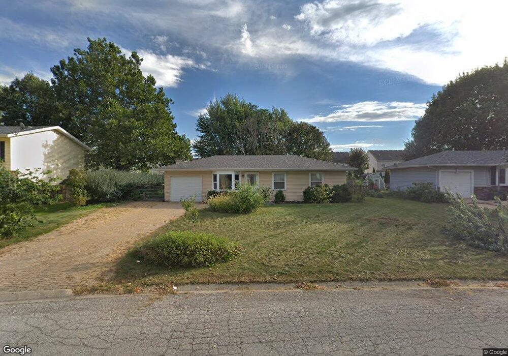
151 Dolores St Oswego, IL 60543
Northwest Oswego NeighborhoodEstimated Value: $257,122 - $322,000
3
Beds
1
Bath
912
Sq Ft
$314/Sq Ft
Est. Value
About This Home
This home is located at 151 Dolores St, Oswego, IL 60543 and is currently estimated at $286,031, approximately $313 per square foot. 151 Dolores St is a home located in Kendall County with nearby schools including Fox Chase Elementary School, Traughber Junior High School, and Oswego High School.
Ownership History
Date
Name
Owned For
Owner Type
Purchase Details
Closed on
Aug 1, 1994
Bought by
Stuebinger Cathy L
Current Estimated Value
Purchase Details
Closed on
Mar 1, 1990
Bought by
Swanson Eric
Purchase Details
Closed on
Jan 1, 1989
Purchase Details
Closed on
Jan 1, 1988
Purchase Details
Closed on
Jan 1, 1985
Create a Home Valuation Report for This Property
The Home Valuation Report is an in-depth analysis detailing your home's value as well as a comparison with similar homes in the area
Home Values in the Area
Average Home Value in this Area
Purchase History
| Date | Buyer | Sale Price | Title Company |
|---|---|---|---|
| Stuebinger Cathy L | $91,500 | -- | |
| Swanson Eric | $83,000 | -- | |
| -- | $69,700 | -- | |
| -- | $58,500 | -- | |
| -- | $51,900 | -- |
Source: Public Records
Mortgage History
| Date | Status | Borrower | Loan Amount |
|---|---|---|---|
| Closed | Swanson Eric | -- |
Source: Public Records
Tax History Compared to Growth
Tax History
| Year | Tax Paid | Tax Assessment Tax Assessment Total Assessment is a certain percentage of the fair market value that is determined by local assessors to be the total taxable value of land and additions on the property. | Land | Improvement |
|---|---|---|---|---|
| 2024 | $4,293 | $65,230 | $18,767 | $46,463 |
| 2023 | $4,346 | $58,766 | $16,907 | $41,859 |
| 2022 | $4,346 | $54,922 | $15,801 | $39,121 |
| 2021 | $4,129 | $50,854 | $14,631 | $36,223 |
| 2020 | $4,033 | $49,373 | $14,205 | $35,168 |
| 2019 | $3,970 | $48,021 | $14,205 | $33,816 |
| 2018 | $3,431 | $40,865 | $12,088 | $28,777 |
| 2017 | $3,180 | $37,491 | $11,090 | $26,401 |
| 2016 | $1,557 | $36,399 | $10,767 | $25,632 |
| 2015 | $1,425 | $32,499 | $9,613 | $22,886 |
| 2014 | -- | $31,552 | $9,333 | $22,219 |
| 2013 | -- | $33,926 | $10,035 | $23,891 |
Source: Public Records
Map
Nearby Homes
- 173 Dolores St
- 102 Mary St
- 2100 Light Rd Unit 109
- 409 Fawn Dr
- 1721 State Route 31
- 7.43 Acres Vacant La State Route 31
- 11-13 W Anchor Rd
- 435 Fawn Dr
- 608 Clearwater Ct
- 602 Clearwater Ct Unit 2
- 5.43 B-3 Commercial State Route 31
- 133 River Mist Dr Unit 3
- 338 Millstream Ln Unit 1
- 403 Lake Ct
- 156 River Mist Dr
- 2110 State Route 31
- 505 Parkland Ct
- Parcel 004 & 003 Illinois 25
- 238 Willowwood Dr
- 125 Presidential Blvd Unit 3248
- 153 Dolores St
- 149 Dolores St
- 602 Manhattan Cir Unit 2
- 604 Manhattan Cir
- 155 Dolores St Unit 1
- 147 Dolores St
- 600 Manhattan Cir
- 606 Manhattan Cir
- 150 Dolores St
- 152 Dolores St
- 157 Dolores St
- 338 Century Dr Unit 2
- 608 Manhattan Cir
- 156 Dolores St
- 145 Dolores St
- 336 Century Dr Unit 2
- 100 Augusta Rd Unit 1
- 136 Augusta Rd
- 159 Dolores St
- 158 Dolores St