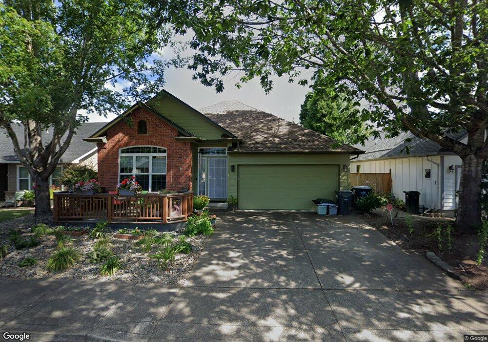
1520 Canal St Springfield, OR 97477
West Springfield NeighborhoodEstimated Value: $462,835 - $542,000
3
Beds
2
Baths
1,449
Sq Ft
$352/Sq Ft
Est. Value
About This Home
This home is located at 1520 Canal St, Springfield, OR 97477 and is currently estimated at $510,209, approximately $352 per square foot. 1520 Canal St is a home located in Lane County with nearby schools including Centennial Elementary School, Hamlin Middle School, and Springfield High School.
Ownership History
Date
Name
Owned For
Owner Type
Purchase Details
Closed on
Apr 21, 2010
Sold by
Prusz Sue H and Pratt Tori L
Bought by
Prusz Sue H and Pratt Tori L
Current Estimated Value
Home Financials for this Owner
Home Financials are based on the most recent Mortgage that was taken out on this home.
Original Mortgage
$180,000
Interest Rate
4.91%
Mortgage Type
New Conventional
Purchase Details
Closed on
Jan 8, 1999
Sold by
Ainslie Krans Inc
Bought by
Pratt Tori L and Prusz Sue H
Home Financials for this Owner
Home Financials are based on the most recent Mortgage that was taken out on this home.
Original Mortgage
$126,400
Interest Rate
6.73%
Purchase Details
Closed on
Mar 18, 1998
Sold by
Eastgate Woodlands Llc
Bought by
Ainslie Krans Inc
Create a Home Valuation Report for This Property
The Home Valuation Report is an in-depth analysis detailing your home's value as well as a comparison with similar homes in the area
Home Values in the Area
Average Home Value in this Area
Purchase History
| Date | Buyer | Sale Price | Title Company |
|---|---|---|---|
| Prusz Sue H | -- | Fidelity National Title Insu | |
| Pratt Tori L | $158,000 | Evergreen Land Title Company | |
| Ainslie Krans Inc | $28,500 | Evergreen Land Title Company |
Source: Public Records
Mortgage History
| Date | Status | Borrower | Loan Amount |
|---|---|---|---|
| Closed | Prusz Sue H | $180,000 | |
| Closed | Pratt Tori L | $126,400 |
Source: Public Records
Tax History Compared to Growth
Tax History
| Year | Tax Paid | Tax Assessment Tax Assessment Total Assessment is a certain percentage of the fair market value that is determined by local assessors to be the total taxable value of land and additions on the property. | Land | Improvement |
|---|---|---|---|---|
| 2025 | $5,058 | $275,831 | -- | -- |
| 2024 | $4,976 | $267,798 | -- | -- |
| 2023 | $4,976 | $259,999 | $0 | $0 |
| 2022 | $4,609 | $252,427 | $0 | $0 |
| 2021 | $4,526 | $245,075 | $0 | $0 |
| 2020 | $4,394 | $237,937 | $0 | $0 |
| 2019 | $4,262 | $231,007 | $0 | $0 |
| 2018 | $4,017 | $217,747 | $0 | $0 |
| 2017 | $3,863 | $217,747 | $0 | $0 |
| 2016 | $3,768 | $211,405 | $0 | $0 |
| 2015 | $3,674 | $205,248 | $0 | $0 |
| 2014 | $3,601 | $199,270 | $0 | $0 |
Source: Public Records
Map
Nearby Homes
- 633 Rowan Ave
- 1723 Dotie Dr
- 1632 Dotie Dr
- 1770 Brandy Way
- 1130 Anderson Ln
- 437 Covey Ln
- 3515 Regent Ave
- 552 W D St
- 930 Prescott Ln
- 475 Riverview Blvd
- 1648 Augusta St
- 0 Summit Blvd Unit 6305 24210629
- 952 Summit Blvd
- 872 W N St
- 835 Willacade Ct
- 804 W N St
- 0 Sylvan St Unit 247715494
- 1120 W Fairview Dr Unit 3
- 1310 W Quinalt St
- 641 City View Blvd