Estimated Value: $134,859 - $185,000
3
Beds
1
Bath
1,080
Sq Ft
$144/Sq Ft
Est. Value
About This Home
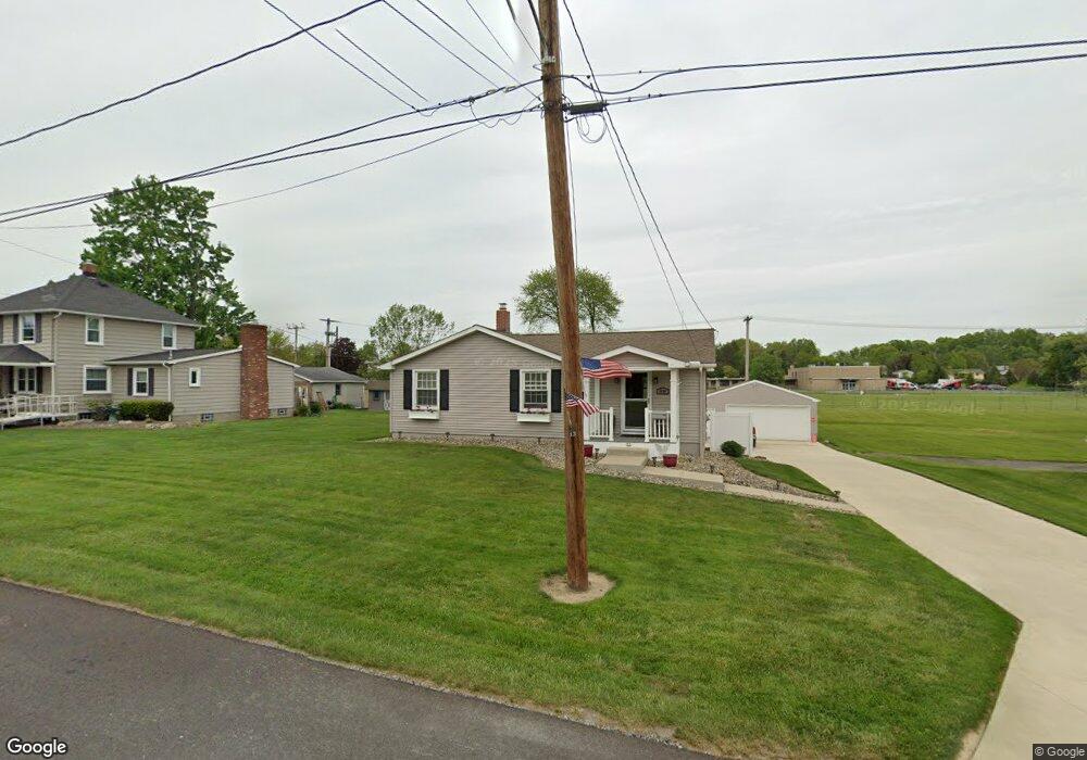
This home is located at 1520 Clark St, Niles, OH 44446 and is currently estimated at $155,465, approximately $143 per square foot. 1520 Clark St is a home located in Trumbull County with nearby schools including Niles Primary School, Niles Intermediate School, and Niles Middle School.
Ownership History
Date
Name
Owned For
Owner Type
Purchase Details
Closed on
Jul 31, 2018
Sold by
Burns Robert D and Burns Gladys C
Bought by
Andrea John J D
Current Estimated Value
Home Financials for this Owner
Home Financials are based on the most recent Mortgage that was taken out on this home.
Original Mortgage
$42,500
Outstanding Balance
$36,755
Interest Rate
4.5%
Mortgage Type
New Conventional
Estimated Equity
$118,710
Purchase Details
Closed on
May 11, 2005
Sold by
Martin Judith D
Bought by
Burns Robert D and Burns Gladys C
Home Financials for this Owner
Home Financials are based on the most recent Mortgage that was taken out on this home.
Original Mortgage
$100,383
Interest Rate
6.05%
Mortgage Type
FHA
Purchase Details
Closed on
May 6, 1999
Sold by
Liguori Nicholas A
Bought by
Martin Judith D
Purchase Details
Closed on
Jan 1, 1990
Bought by
Nicholas A Liguori
Create a Home Valuation Report for This Property
The Home Valuation Report is an in-depth analysis detailing your home's value as well as a comparison with similar homes in the area
Home Values in the Area
Average Home Value in this Area
Purchase History
| Date | Buyer | Sale Price | Title Company |
|---|---|---|---|
| Andrea John J D | $110,000 | None Available | |
| Burns Robert D | $102,000 | -- | |
| Martin Judith D | $79,500 | -- | |
| Nicholas A Liguori | -- | -- |
Source: Public Records
Mortgage History
| Date | Status | Borrower | Loan Amount |
|---|---|---|---|
| Open | Andrea John J D | $42,500 | |
| Previous Owner | Burns Robert D | $100,383 |
Source: Public Records
Tax History Compared to Growth
Tax History
| Year | Tax Paid | Tax Assessment Tax Assessment Total Assessment is a certain percentage of the fair market value that is determined by local assessors to be the total taxable value of land and additions on the property. | Land | Improvement |
|---|---|---|---|---|
| 2024 | $1,433 | $34,270 | $4,590 | $29,680 |
| 2023 | $1,433 | $34,270 | $4,590 | $29,680 |
| 2022 | $1,142 | $23,320 | $4,590 | $18,730 |
| 2021 | $1,200 | $23,320 | $4,590 | $18,730 |
| 2020 | $1,211 | $23,320 | $4,590 | $18,730 |
| 2019 | $1,161 | $21,290 | $2,560 | $18,730 |
| 2018 | $1,158 | $21,290 | $2,560 | $18,730 |
| 2017 | $1,151 | $21,290 | $2,560 | $18,730 |
| 2016 | $1,105 | $20,240 | $2,560 | $17,680 |
| 2015 | $1,093 | $20,240 | $2,560 | $17,680 |
| 2014 | $1,097 | $20,240 | $2,560 | $17,680 |
| 2013 | $1,156 | $22,510 | $2,560 | $19,950 |
Source: Public Records
Map
Nearby Homes
- 352 N Rhodes Ave
- 340 Mcevoy Ct
- 126 S Rhodes Ave
- 107 Hogarth Ave
- 1804 Stepney St
- 21 Summit Ave
- 1919 Carnegie Heights Dr
- 364 Hogarth Ave
- 311 High Ave
- 29 S Bentley Ave
- 839 Robbins Ave
- 404 N Bentley Ave
- 820 Hartzell Ave
- 504 High Ave
- 17 Belmont Ave
- 39 Belmont Ave
- 733 N Bentley Ave
- 2213 N Glenwood Ave
- 737 N Bentley Ave
- 0 Summit